| 00:00 | Um But since we're recording, you're , OK. Um I posted |
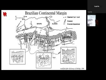
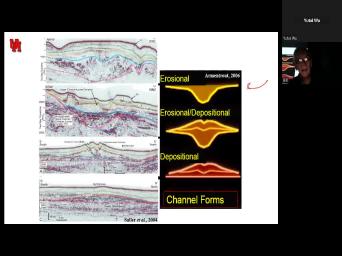
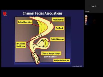
|
| 00:08 | a modified set of notes just a of hours ago on Hyper Pit |
|
| 00:14 | So you're gonna see a bunch of that you don't have in your |
|
| 00:18 | Uh Just note that those uh images all in the new nodes and you |
|
| 00:25 | go and, and look at that we go. OK. Uh But |
|
| 00:29 | do want to talk uh more about Picts in a marine setting, particularly |
|
| 00:33 | deep marine setting. Um And, what we know about them is that |
|
| 00:41 | they are basically flood triggered. Uh ba uh and, and we talked |
|
| 00:48 | them both in the context of lacustrine and marine deltas. Uh They are |
|
| 00:55 | fact more common in lacustrine deltas, we do get them in marine |
|
| 01:01 | And in particular, when we get the shelf edged deltas, we have |
|
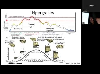
| 01:07 | hyper pics providing sands into the deep . Uh This particular uh image simply |
|
| 01:14 | the difference between a uh kind of long lived sedimentary gravity flow. Uh |
|
| 01:20 | called here, a quasi steady low turbo current that's really gonna be your |
|
| 01:26 | or uh is it gonna be the uh generated or storm generated uh single |
|
| 01:36 | ? Ok. Now, in this here, what we're looking at is |
|
| 01:42 | single but simple event. Uh and , this is the flood discharge increasing |
|
| 01:50 | decreasing and the resulting deposit. If discharge doesn't exceed some critical discharge to |
|
| 02:01 | that turbidity current, you're not gonna a turbidity current. You're just gonna |
|
| 02:06 | the waning flow deposition from suspension. as that critical discharge is exceeded and |
|
| 02:14 | the discharge of the river mouth then you begin to see this secondary |
|
| 02:27 | increasing flow. And in fact, even going to have some erosion followed |
|
| 02:36 | deposition. So you see this little surface here, OK. Uh So |
|
| 02:42 | getting increasingly more complex uh patterns. , uh here, for example, |
|
| 02:52 | a, a, an example of single hyper pic that is extending farther |
|
| 03:04 | farther offshore or perhaps laterally and how changes with distance. So when it's |
|
| 03:12 | to the um with the maximum you've got a lot of scour fining |
|
| 03:19 | . Uh Here, you don't get mud fragments here. You're getting more |
|
| 03:24 | a increase, decrease, increase, and just barely have. And so |
|
| 03:31 | got a muds stone face, shes sandstone face, she and a pebbly |
|
| 03:37 | that pretty much is at the base present. And that's only going to |
|
| 03:42 | when we uh have very high flows . Ok. Now, more |
|
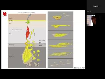
| 03:51 | we're looking at particularly with the river flood, a longer lived event that |
|
| 03:57 | highs and lows. Um So it's have a peak, a low, |
|
| 04:02 | peak and low. But in we're gonna have accelerating flow to the |
|
| 04:07 | where erosion and bypass, followed by and deposition. OK. And so |
|
| 04:13 | is uh a sequence of what's happening in terms of the deposition as we |
|
| 04:24 | the strongest flow and it might look like this. OK. So notice |
|
| 04:30 | this one here, I'm gonna focus this one. Uh We have a |
|
| 04:35 | of repetition. In other words, no single sequence like shown here, |
|
| 04:41 | rather, there's some repetition of uh to yellow, to orange, to |
|
| 04:48 | , to ripples, to yellow, ripples to mud. OK? And |
|
| 04:52 | of these has a fay name. I'm not too concerned with the |
|
| 04:58 | So you're gonna get them in a . But the point is that you |
|
| 05:03 | having various times during which different fishes deposited during that decelerating flow. |
|
| 05:17 | It turns out the reason I had add illustrations is I've completely forgotten about |
|
| 05:25 | particular paper that really is probably the best paper on Hyper, particularly in |
|
| 05:31 | marine setting. And it's published in really bizarre journal that I don't normally |
|
| 05:36 | uh lithic reserves or re uh uh . But essentially, you're looking at |
|
| 05:45 | , this coarsening and finding and coarsening finding event ok, similar to what's |
|
| 05:51 | on here. And we're looking at it varies distantly. And one of |
|
| 05:57 | things is that you've got a bed component and a suspended component, bed |
|
| 06:03 | drops out suspended is deposition and notice happening here. We're beginning to have |
|
| 06:09 | loft. The, the head of hyper pics is actually beginning to become |
|
| 06:18 | dense and is floating. And then other things, you have settling out |
|
| 06:24 | suspension. And one of the things settle out of suspension, a lot |
|
| 06:28 | organic materials including leaves. So this the way we end up seeing leaves |
|
| 06:35 | deep water setups by these hypericon night are coming from the near shore. |
|
| 06:40 | there's a face bs face, Well, that's basically bed load sand |
|
| 06:50 | . And so here's what it kind looks like. Um Here's massive |
|
| 06:57 | that's one of the most common species the hyper pic event. OK. |
|
| 07:05 | This is the downstream change there. what we were looking at here, |
|
| 07:13 | down current and it could extend for of kilometers. Yeah, here is |
|
| 07:24 | change. What this is doing. extending away from the channel. It |
|
| 07:29 | if you like the levies. So in the channel itself, we |
|
| 07:35 | bed load deposition. But as we away from the channel, just like |
|
| 07:41 | we move down current, we're going this massive sand, that's arguably the |
|
| 07:50 | important because that's gonna be your best . And then as it gets farther |
|
| 07:55 | , you're getting, uh, intubated , rippled sands, uh, and |
|
| 08:00 | eventually it's beginning to loft and then beginning to get the, uh, |
|
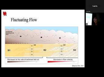
| 08:07 | stones of the loft faces. Ok. So here we've got this |
|
| 08:15 | flow and we've got three faces Faces, one faces to in phases |
|
| 08:31 | Fay three is climbing ripples. Faces is parallel lamination and faces, one |
|
| 08:41 | massive. Ok. So you go massive to parallel laminated to climbing |
|
| 08:49 | But notice that it kind of goes and forth. And so what we |
|
| 08:56 | here is something that might be S , S 2, S one |
|
| 09:04 | S two S 1. OK. all of that is one flow but |
|
| 09:10 | varying discharges and velocities and sediment concentrations a flood from the river's mouth. |
|
| 09:18 | we look down here, we're getting sim similar fluctuation but of a more |
|
| 09:25 | face. She here we're getting That would be three, two. |
|
| 09:35 | I can't read it. Uh But , this would be uh anyway, |
|
| 09:44 | it ripple. That would be 232 . OK. So you get these |
|
| 09:52 | , OK. By the time you down to the lofting face sheets where |
|
| 09:57 | getting basically muds and there you're getting and decrease velocities showing increasing and decreasing |
|
| 10:09 | and mud size. So it looks like this and a single event may |
|
| 10:16 | you multiple cycles because you're just looking the tail of these things. |
|
| 10:23 | So, in summary, if you're at that fluctuating uh hydro graph, |
|
| 10:33 | you like uh with the initial deposition when this is coming through and you're |
|
| 10:40 | , uh just uh a little bit sediment here but not much. It's |
|
| 10:46 | acceleration. Now, you're getting erosion bypass, notice you're getting erosion down |
|
| 10:53 | and then it's bypassing over here. you're getting sand to mud, |
|
| 11:01 | to mud as if it's a levee you're still eroding the channel and then |
|
| 11:10 | deceleration and deposition. And that's when get deposition in the channel of coarsening |
|
| 11:18 | or finding upward sequence from the gravels the middle to um massive beds and |
|
| 11:26 | currents. And then out here, , um you get the basically S3 |
|
| 11:38 | floating. Ok. And these again gonna be alternating depending on these fluctuations |
|
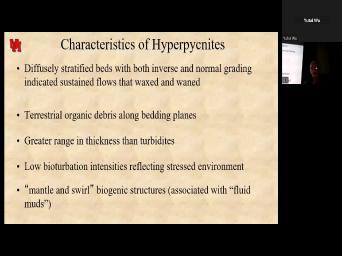
| 11:46 | . Ok. So, characteristics. Well, actually I should have done |
|
| 11:53 | . Oh, I'm sorry, I'm gonna let you read these a |
|
| 11:57 | of big things, uh greater range thickness, uh terrestrial organic debris indicating |
|
| 12:05 | drive from a river inverse and normal within a single event. Now, |
|
| 12:12 | is different than a hybrid bed. I find hybrid bread still kind of |
|
| 12:21 | , but the main thing about a bed is that you're incorporating or losing |
|
| 12:28 | during a single event. So you're adding mud from the bottom or you're |
|
| 12:34 | mud from the top. And so changing the viscosity and the nature of |
|
| 12:40 | , the bed hyper pic nights fluctuate the event. And so you're not |
|
| 12:50 | at something added or subtracted in but rather you're looking at fluctuations in |
|
| 12:57 | source from that flood event. Um They're most common in lacustrine |
|
| 13:05 | but most rivers can produce them and of them are pretty common uh even |
|
| 13:11 | submarine cans. So these uh have recognized again, classic, you find |
|
| 13:20 | you look for and we're seeing these and more both in the rock record |
|
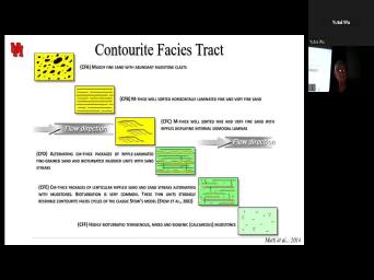
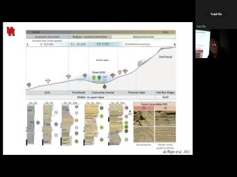
| 13:25 | instrumented in studies of modern deposits. . Those add contour rights and |
|
| 13:34 | a, A type of deposit that ignored until about 10 years ago, |
|
| 13:41 | or better said, ignored by the community because it was thought that these |
|
| 13:46 | just generate muds. Ok. Uh , in reality, there are any |
|
| 13:52 | sea sediment deposited and or substantially reworked bottom curs. Ok. So what |
|
| 14:01 | those bottom currents? They're thermo haing currents? They're driven by differences in |
|
| 14:07 | and salinity and they are global in , their extent. Ok. So |
|
| 14:15 | are, this path is just some the examples of these global uh thermo |
|
| 14:22 | bottom currents. Now, when these first described, they actually were described |
|
| 14:29 | silts and there's mud to silt, mud. Ok. Uh They modified |
|
| 14:36 | and we're gonna see the big changes occurring in here, but notice that |
|
| 14:41 | we look at this one, uh actually into fine sand now and we're |
|
| 14:47 | at a gradual increase and decrease in size. OK. And, and |
|
| 14:53 | a little bit here, the reason that is that these bottom currents are |
|
| 15:00 | continuous in velocity and location, bottom meander, they move back and forth |
|
| 15:08 | and when they move away, the decreases, when they move towards |
|
| 15:14 | it increases. And so what this package is looking at is one kind |
|
| 15:21 | back and forth motion of a bottom , ok? And this is an |
|
| 15:27 | of a core of one of those currents that's basically getting higher and higher |
|
| 15:36 | into the sand, lower and lower the mud. And so we actually |
|
| 15:44 | getting some pretty good sand deposits, fine grain sand, but they are |
|
| 15:50 | sorted. So what we end up are three types of contour rights, |
|
| 15:57 | bedded, thin uh thick bedded, , thin bedded, sandy and |
|
| 16:04 | thick bedded, sandy are what we're interested in for reservoirs. They're horizontally |
|
| 16:10 | , and ripple, laminated, fine , well, sort of sand |
|
| 16:14 | ok. Um The thin bit and I'll show a picture. So, |
|
| 16:20 | here's the thick bit at sandstone, ? And these can be in commonly |
|
| 16:26 | units of 2 to 8 m. mean, this is a thick sequence |
|
| 16:30 | basically, it's reporting that interval of when the contour current was closest and |
|
| 16:39 | high velocities. Ok. Uh They be units up to 30 m. |
|
| 16:45 | , we'll see a couple. The thin bedded uh are a little |
|
| 16:53 | grain and they are kind of in . They're getting more impacted by the |
|
| 17:02 | flow as well as the uh increasing velocities. And then as you get |
|
| 17:09 | away, you're just getting mud. ? And so, uh these are |
|
| 17:14 | much extensively bioturbated uh and are gonna our seals and potentially our sources. |
|
| 17:22 | . Um Sandy contour rides occur in , what we call terraces and at |
|
| 17:29 | exit of straits or gateways, the uh is basically a, a place |
|
| 17:36 | contour currents having been funneled, spread . OK. So we're uh we're |
|
| 17:43 | look at some of those and you read uh this a little later but |
|
| 17:48 | a look at this. Uh look thick That uh uh amalgamated Sandstone is |
|
| 17:56 | uh most of the porosity over OK? And then this would be |
|
| 18:07 | the, these are sandy. Uh then in here, uh we're looking |
|
| 18:13 | some finer grain deposits, OK? straits of Gibraltar uh have very saline |
|
| 18:25 | waters coming out of the Mediterranean. so as it outflows, it's called |
|
| 18:29 | Mediterranean outflow of waters. And those come out here, they form channels |
|
| 18:40 | in particular, They form areas where red is over 50% sand. The |
|
| 18:48 | red is over 75% sand. So are really very sandy deposits over hundreds |
|
| 18:57 | kilometers, allergy skin thing uh covers 4000 square kilometers, ok. High |
|
| 19:10 | to gross thickness of over 800 So this is a huge deposit as |
|
| 19:17 | modern analog or ancient contours. there's a lot of geometries by which |
|
| 19:25 | things uh accumulate. This is just of them. Uh Let's look at |
|
| 19:30 | here. This is um a You notice that the turbo has been |
|
| 19:46 | moving towards this channel may even be a little slumping here. Ok. |
|
| 19:56 | is completely welded on. So it's , there's the contour right right |
|
| 20:03 | but it, the velocity decreases. fact, if we look at it |
|
| 20:09 | , There's two water masses is one towards us and one moving away from |
|
| 20:18 | where the velocities are the greatest right here. We're actually getting sandy face |
|
| 20:29 | rating offshore into muddy faces and this just a mass transport complex. So |
|
| 20:36 | we were looking at a face track here to hear, would look something |
|
| 20:42 | this. Well, I'm, I'm gonna read this to you except to |
|
| 20:48 | here's a muddy fine sand, here's laminated sand, thick bedded, here |
|
| 20:57 | climbing ripples, uh bedded sand here wavy lenticular and muds. So what |
|
| 21:08 | actually have is a transition from sand mud. It looks a lot like |
|
| 21:16 | tradition we would get in a tidal . Ok. Wow. Here's some |
|
| 21:24 | of what they look like. And that uh massive channel bottom, there's |
|
| 21:31 | horizontally bedded, it, this doesn't mass but mass it would typically form |
|
| 21:37 | between these two, um, rippled . But, ok, so that's |
|
| 21:50 | face she track you get here. is missing in that? Is that |
|
| 21:56 | sound? Ok. So here's our bedded, thin bedded And Muddy as |
|
| 22:08 | that is mixtures of the two, mean of the different faces. Here's |
|
| 22:16 | contra channel. The contrast is moving like this. Yeah. And if |
|
| 22:24 | look at the faces going from the down, we get a sandy |
|
| 22:35 | right? Getting more muddy, more , getting thinner to muds. |
|
| 22:43 | This up here is stuff that's coming from the slope. OK? And |
|
| 22:49 | would be the channel, OK? that would be like this right |
|
| 22:55 | So we get such high velocities in contour I channels that we can actually |
|
| 23:00 | gravel transported. Uh This is just picture showing the same thing, the |
|
| 23:06 | , right channel with the Corus sandy contour rights, then they're getting finer |
|
| 23:14 | , interbedded with muds. It would this one it and again, this |
|
| 23:22 | just pictures showing what that lateral transition be right here. And pretty much |
|
| 23:38 | same, this is the Paleo Mediterranean water flow. So this is looking |
|
| 23:47 | some older deposits, but with the geometry of gateways skipped it. |
|
| 23:56 | what's stunning is that the more and we look at contour, right, |
|
| 24:03 | contour currents, The more we find sand and two bed forms in that |
|
| 24:14 | . So here we're looking at basically high velocity. This is in |
|
| 24:23 | the funnel gateways like within the straits Gibraltar and within the channels along the |
|
| 24:31 | , they would go down to the and finally the finer grain drifts. |
|
| 24:36 | look what's happening here. We get features like furrows, uh then gravel |
|
| 24:48 | and even barca dunes. Then as get into a little uh slower |
|
| 24:57 | we're going from large sand waves to sand waves to three dimensional ripples to |
|
| 25:08 | dimensional ripples, straight crested ripples, ? OK. That's our flow rece |
|
| 25:14 | seeing the same flow regime that we in unidirectional currents in a river in |
|
| 25:21 | counter, right? And eventually it into smooth sand deposited from suspension. |
|
| 25:31 | . Some of these Big Barca dunes five or 10 m high wavelengths of |
|
| 25:40 | of meters. OK. Now, was really uh prophetic in pushing the |
|
| 25:54 | early on that contour rights could be processes on turbo channel levies. |
|
| 26:06 | And what we see here is a of the levee deposit and a redeposition |
|
| 26:15 | material. OK. And so he that you might go from coarse grained |
|
| 26:24 | beds to lasure bedding and the bedding of the winnowing of the channel and |
|
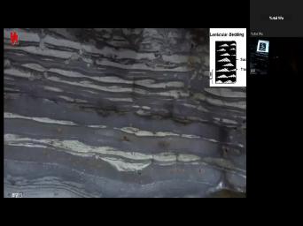
| 26:36 | . And certainly we see that we that in the Delaware Basin. Uh |
|
| 26:40 | see lenticular bedding. Uh We see bedding, uh rhythmic betting. The |
|
| 26:48 | are this down in here, probably cycles. Um These are all in |
|
| 26:57 | water deposits right next to a great submarine channel. Ok. So when |
|
| 27:06 | , when you see this, you directional currents, you see mixed |
|
| 27:12 | hetero lithic betting, climbing ripples, . All of these are typical of |
|
| 27:22 | higher energy portions of contour rights, , levy deposits. Ok. |
|
| 27:30 | this more just for general information, is what a down current turbidity, |
|
| 27:37 | might look like. Ok. Um I won't get into the details of |
|
| 27:41 | , but this is what a right? Might look like. Reworking |
|
| 27:48 | channel and letting. Ok, so we've got is channel deposits here. |
|
| 28:02 | reservoir properties, reworked ripples and uh to coarse grain sand. Again, |
|
| 28:15 | reserve properties, medium defined grain that variable. And by the time |
|
| 28:21 | get down to here, uh we've too much mud. It's gonna be |
|
| 28:28 | or reservoir conceivably um tight, uh rather uh conceivably little fingers, but |
|
| 28:38 | it's gonna be tight. Ok. the idea of contour currents, reworking |
|
| 28:50 | or channels uh is getting increasing interest the last few years. Now, |
|
| 28:57 | this particular case, we've got a lobe and we see sand moving down |
|
| 29:08 | here. We've got the con or superimposed on the turbo and that's where |
|
| 29:16 | get these pro grading drifts that are the turbo channel to migrate. In |
|
| 29:29 | words, if this was the channel , I mean, then the deposition |
|
| 29:39 | causing it to migrate a flow if like OK, up flow in the |
|
| 29:46 | of the contour current. OK. these are just some examples and you |
|
| 29:53 | look at these at your leisure. But this would be what's happening as |
|
| 29:57 | going down the axis of the And this is as you're going down |
|
| 30:03 | margin of the channel. So here got that lateral change of the |
|
| 30:16 | Uh This is just showing what some these fine reigned uh contour. Rs |
|
| 30:25 | grain, uh medium grain sand look well sorted they are. Yeah. |
|
| 30:34 | we can have some very well And as I showed earlier, thick |
|
| 30:40 | and it not only is a way generating con uh more sandy contra rights |
|
| 30:52 | is leaving behind winnowed turbos. um moody called these the mystery of |
|
| 31:02 | missing turbos. And it really wasn't much that the turbo was missing, |
|
| 31:08 | the upper part of the turbo was . Now, we typically assume that |
|
| 31:13 | upper muddy part which is kind of low density turbidity current is simply continues |
|
| 31:20 | offshore, farther down street. And one process that happens. But if |
|
| 31:27 | high and low density turbo is coming the channel at the same time that |
|
| 31:33 | have a unidirectional contour, right. , this is actually stripping that finer |
|
| 31:42 | turbo and finer grain material in depositing down, dr enhancing the grain size |
|
| 31:50 | the porosity and permeability of that lower turbo. So here we've got a |
|
| 31:58 | sandy contour eye, ok? Great , muddy con and pretty good |
|
| 32:08 | OK? And it may even be source uh particularly given the or high |
|
| 32:16 | content that's coming down these things from and if it's deposited in an anoxic |
|
| 32:23 | , ok. So just show a of field examples. Uh We've got |
|
| 32:30 | near Mozambique, we've got a series fields that are giant fields. They're |
|
| 32:37 | of the most prolific exploration areas in world with over 80 trillion cubic feet |
|
| 32:43 | natural gas in place mainly in So there's the coral in the mamba |
|
| 32:51 | . OK? So here they are this is the depositional model. These |
|
| 32:58 | grain turbos are diverting the turbidity currents the channels and they are winnowing out |
|
| 33:17 | upper part of those dense flows, them in the lower part of this |
|
| 33:29 | drift. So the highest net to here are the main channel as well |
|
| 33:41 | some gravity flows that are coming in uh lobes and some of the |
|
| 33:52 | The closest areas of the drift. . Love net is uh um isolated |
|
| 34:04 | and the distal portions of the OK? And non reservoir shales. |
|
| 34:10 | . So we've got am giant gas whose main reservoirs are basically a |
|
| 34:22 | right? Winnows channel. Also some lobes down channel and the most |
|
| 34:32 | portion of the, the drift. other area that is massive contour fields |
|
| 34:40 | in Brazil offshore. These are sub salt, uh the Santos Basin, |
|
| 34:48 | compost basin in the Santos Basin. . Here's the southern Santos Basin. |
|
| 34:55 | what we're looking at is channels coming here and even lobes. And here |
|
| 35:07 | the erosional can do it of a , right? And their erosion |
|
| 35:17 | But take a look. Here's some can dunes. Uh Here's some sandy |
|
| 35:25 | . I out here, if we at those bar can dunes. Uh |
|
| 35:32 | are sand waves in here. Big can dunes and linear stripes. So |
|
| 35:39 | highest velocity is in the core of contour I channel and this is the |
|
| 35:48 | as the velocities are getting lower and . OK. And this is just |
|
| 35:54 | looking at some of the sizes of , some of those bar cans are |
|
| 36:02 | m high and a couple of kilometers . So it's not your like Zan's |
|
| 36:08 | can uh also get larger dune Um Where you've got all of this |
|
| 36:18 | sand, well sorted, sand skip um in the compost basin, here's |
|
| 36:31 | con rights again. And they are the distal lobes. OK. |
|
| 36:40 | instead of reworking the channel, they're the lobes and in the Santos Basin |
|
| 36:49 | , a lot of reworked deposition reworked channels and associated sandy contour |
|
| 37:01 | OK? OK. So let's call quits for now. Um I'm going |
|
| 37:09 | uh stop sharing. We're gonna take short break and then we're gonna start |
|
| 37:16 | part two and that is the Ok. Ok. Ok. |
|
| 37:36 | we recording. Ok, great. you. Ok. Um, |
|
| 37:40 | let's look at these systems in terms their storyline because surprisingly, well, |
|
| 37:55 | me, it was a surprise that you begin to look at deep water |
|
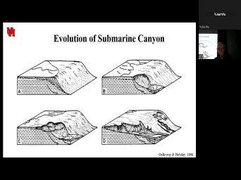
| 38:00 | throughout the world, they often in fact, most commonly have a |
|
| 38:06 | sequence, a recurring sequence of patterns it begins with slope failure. And |
|
| 38:17 | forms a canyon and that canyon eventually until it captures a sediment supply. |
|
| 38:27 | that sediment is bypasses the slope to deposited as a basement for a |
|
| 38:37 | And that as the sediment begins to , get more muddy, you tend |
|
| 38:43 | backfill the canyon with the channel levee and eventually mud grapes, hemi planted |
|
| 38:54 | . Now, there's a lot of in transit, but that's a storyline |
|
| 39:01 | we're gonna basically find provides a framework thinking about how these multiple sequences of |
|
| 39:13 | occur. So let's begin with getting uh getting sediment uh off the shelf |
|
| 39:22 | into the deeper water. And that course involves uh this complicated bemet that |
|
| 39:31 | see on the slope and slope failure particular. And there's a lot of |
|
| 39:37 | for this. Uh in some deposition can cause loading uh and that |
|
| 39:45 | result in sheer drink reduction and failure uh in other cases, uh you've |
|
| 39:53 | tectonic or sea level change that can in increased stress, uh and slope |
|
| 40:01 | a lot of these different ways. as you might expect, there's AAA |
|
| 40:08 | variation, not only in terms of and mechanisms for slow failure, but |
|
| 40:13 | the scale and geometry of those But let's just imagine in a, |
|
| 40:20 | a simple form, we've got the gradation of the shelf and failure. |
|
| 40:28 | Failure beginning here is a large slump slump begins to work his way across |
|
| 40:38 | stream. Until finally, it has least the potential for intercepting sediment and |
|
| 40:48 | deposition of the van. And you notice here there's deposition that occurs |
|
| 40:53 | the initial rather at the initiation of slop, that's our mass transport |
|
| 41:02 | But as it expands, we begin cover that, uh we are aware |
|
| 41:07 | we will begin to cover that with the deep water deposits uh that we're |
|
| 41:15 | interested in. Uh We actually talked one variation of the theme when we |
|
| 41:21 | at the, the Wilcox in South on shelled deltas and the, the |
|
| 41:29 | of a swamp followed by the filling that by a delta. OK. |
|
| 41:40 | We also can talked about failure that occur when the delta propagates beyond a |
|
| 41:50 | shelf edge. Now, this story that shows that failure will occur |
|
| 42:01 | OK. And then eventually we'll have and more sediment following it. Doris |
|
| 42:13 | suggested this in my scene of the of Mexico back in the 50s. |
|
| 42:19 | . The recognition of certain types of now this failure can be small or |
|
| 42:26 | the case of the coastal plains, can be a regional growth fault system |
|
| 42:33 | extends for the whole extent of the show. And so here's some examples |
|
| 42:40 | that. Uh we've got a uh here, a failure here and, |
|
| 42:48 | notice the failure was initiated at the edge and that failure resulted in a |
|
| 43:00 | transport complex that was then covered. another failure covered another failure. |
|
| 43:11 | So these are, are quite Now, when you think about ways |
|
| 43:18 | get sediment beyond the shelf, certainly whole line of collapsed shelf edges is |
|
| 43:28 | way, another way is to create point source, which is a |
|
| 43:36 | Now, obviously, as we talked that canyon doesn't start as a canyon |
|
| 43:42 | , it has to work its way . But once it does that it's |
|
| 43:49 | a source. Now, some you can basically the source can come |
|
| 43:54 | the shelf edge, those are shelf deltas. And in other cases, |
|
| 43:59 | source can come to the shelf edge having sediment provided by longshore drift. |
|
| 44:07 | , that could be a contour, that or rather an oceanic current that |
|
| 44:12 | onto the shelf. And we talked that with the so a shelf in |
|
| 44:19 | Africa where the current uh comes on and then can provide sediment uh going |
|
| 44:27 | the shelf. So these are all of which getting sediment into this. |
|
| 44:33 | slope and beyond, uh Monterey Canyon longshore drift. It's not really at |
|
| 44:44 | , at a delta hit, it longshore drift. Um That would be |
|
| 44:50 | like this Mississippi Canyon today. Uh not transport much sediment. It was |
|
| 45:01 | a good example of a retrograde system intercepted uh an earlier Pleistocene low with |
|
| 45:11 | Mississippi, the Congo inter is basically a, a submarine canyon in its |
|
| 45:24 | and, and this is something to in mind that we don't have to |
|
| 45:30 | a low standard of sea level to sediment into and beyond the shelf or |
|
| 45:37 | into and uh uh a submarine canyon bypass the shelf. OK. So |
|
| 45:43 | is a high stand feature. These are big. Uh Here's the Grand |
|
| 45:50 | Monterey Canyon, Mississippi Canyon. These the same scale as the Grand |
|
| 45:56 | Um And some canyons are even larger that. Um There's a recent uh |
|
| 46:05 | , I'll, I'll talk more about later. Um The most recent. |
|
| 46:12 | . A compendium of articles about deep systems was just published a couple of |
|
| 46:19 | ago, actually last March. Um um I can't remember the uh here |
|
| 46:34 | so when you see Russ uh Rusian all, that's from this publication, |
|
| 46:41 | . I can't put that uh in reading list because I'm not allowed to |
|
| 46:47 | it. OK. Uh But we'll about that later. Uh Here is |
|
| 46:53 | example of a single thread canyon typically the mouths of a large river that |
|
| 46:59 | be the Congo, for example, could also be the indus delta, |
|
| 47:03 | could also be the Jiu Delta. there is a canyon that basically is |
|
| 47:11 | , cutting into bedrock has got tributaries it's often structurally controlled Monterey submarine canyon |
|
| 47:18 | excavating a bedrock fault. And then Mississippi Canyon is a large scale canyon |
|
| 47:25 | is being modified by side slumps in mobile substrate. And on the |
|
| 47:33 | you see the, the model where have a bunch of little slumps, |
|
| 47:38 | canyons, they begin to merge uh eventually they become amalgamated Into one large |
|
| 47:52 | . OK? Yeah, let's think the Gulf of Mexico for a little |
|
| 48:02 | . Here's the Mississippi Canyon as big it is. It's small compared to |
|
| 48:07 | of these other canyons. Uh So got Plio Plyo submarine canyons all over |
|
| 48:14 | Gulf of Mexico and the they are these big ban systems, which is |
|
| 48:24 | what we refer to as the Mississippi . OK. And here are um |
|
| 48:29 | ship breaks at different times. Now, here actually, yeah, |
|
| 48:39 | , the here is late pliocene to . If we go farther onshore, |
|
| 48:46 | get into some Paleocene canyons like the canyon at the Lavaca canyons shown |
|
| 48:56 | cuts into delta front deposit shelf delta front and it is forming at |
|
| 49:04 | shelf edge of what is in essence ancestral Colorado Delta. There's another ancestral |
|
| 49:13 | delta that's feeding deep water fans and merge to form a submarine fan |
|
| 49:24 | That is the Wilcox equivalent of the fan today. Yeah. What I |
|
| 49:41 | to that? Ok. Uh, little younger. Uh, and the |
|
| 49:51 | is the Yoakum Canyon and its channel is mud and it's several 1000 ft |
|
| 50:02 | mud. Ok? I ran into in the Miss in an ancestral |
|
| 50:08 | I'm sorry, ancestral Monterey Canyon Where was looking at well, logs and |
|
| 50:15 | were basically shallow water deposits or let's say, Sandy deposits. And then |
|
| 50:21 | of a sudden the well log had ft of mud and what we had |
|
| 50:32 | was an ancestral butt. Can you of Monterey candy? Well, here |
|
| 50:40 | got that deep canyon fill. The Canyon, which is shown here and |
|
| 50:49 | we have shelf edge collapse and here feeding again a younger, um, |
|
| 51:02 | lower color. Yeah, that should been middle Colorado anyway, uh, |
|
| 51:06 | feeding another, uh, portion of Colorado system, this merging to form |
|
| 51:15 | fans. So the, the Lavaca Yoko represent large failures of the Paleocene |
|
| 51:29 | of slope edge. We have them the Houston Delta. We have them |
|
| 51:34 | the Holly Springs Delta. That's, the way is the ancestral Mississippi. |
|
| 51:38 | got them in the Lobos Delta. the ancestral Rio Grande. And we've |
|
| 51:42 | them all along here down in um, uh, rather in |
|
| 51:50 | um, Mexico. Something happened at time to cause the shelf edges to |
|
| 51:59 | unstable, most likely related to changes sea level. Uh, but there's |
|
| 52:07 | a one, uh, time or , there's not a singular event. |
|
| 52:12 | , it is rather a singular It's something that happened all along the |
|
| 52:17 | margin. Now, the other thing note is that not all canyons make |
|
| 52:27 | past the sh or onto the there are some small slope canyons that |
|
| 52:37 | do nothing more than erode whatever is the slope, most of which is |
|
| 52:42 | . So those are mud rich canyons do not produce a submarine fan. |
|
| 52:51 | canyons that produce the submarine fan have cut onto the slope and intercept either |
|
| 52:59 | delta or longshore drift in order to a sandy fan. Now, one |
|
| 53:09 | the things I'll point out look at aligned potholes marks. This is back |
|
| 53:19 | 2011, 10 years later, we've a paper coming out showing how linear |
|
| 53:29 | uh pot marks appear to be the in which slope channels are initiated. |
|
| 53:41 | . And this is one of the things about being outside the industry. |
|
| 53:49 | People know about things way before they're . And so there's little hints in |
|
| 53:56 | papers and then finally, it's released publication. OK. So we see |
|
| 54:02 | pock marks, maybe gas generated, something else that begin to align themselves |
|
| 54:08 | create these And in essence type one mud rich shelf fans that some, |
|
| 54:19 | of which may eventually amalgamate to become uh type I'm sorry. Um These |
|
| 54:27 | a type of twos moving into type . You can see why I hate |
|
| 54:32 | use the terms type A and B and two. I get them mixed |
|
| 54:39 | . Here's an example of a canyon although it's not in the river's mouth |
|
| 54:50 | is getting sediment from the Ganges The thade dominated delta, the highest |
|
| 54:58 | of accretion uh almost 10 cm per is occurring right here in the head |
|
| 55:07 | the delta or rather in the head the submarine fan. OK? So |
|
| 55:13 | getting a lot of sediment loading, fan moving herds and other sedimentary gravity |
|
| 55:20 | off offshore. Same thing is happening . You got a lot of longshore |
|
| 55:26 | that's depositing in the head of the submarine canyon that has created submarine gravity |
|
| 55:34 | that are active today. Now, idea that some canyons, the heads |
|
| 55:48 | some canyons are restricted to the slope some go all the way across uh |
|
| 55:55 | a snapshot in time. But the thing that can happen is during a |
|
| 56:00 | stand, you can have these small that might even intercept the slope. |
|
| 56:08 | mean intercept the shelf but don't intercept source of set I'm sorry. Sandy |
|
| 56:18 | only some cut across the entire shelf would be like the or the or |
|
| 56:26 | Con uh Congo or Monterey Bay. canyons will deposit a fan during high |
|
| 56:37 | . But as sea level drops, though smaller canyons begin to intercept the |
|
| 56:46 | source, so now we begin to an amalgamated sand fan. That is |
|
| 56:55 | compilation. All of those. During the times when there's only a |
|
| 57:05 | stand, intercepting sediment, there's no to the shelf edge. OK? |
|
| 57:12 | still getting fans develop. OK. the canyon. But those fans are |
|
| 57:23 | by on lap, on lap of lower slope or on lap of the |
|
| 57:29 | because the slope is not pro OK. Remember it's a high |
|
| 57:34 | On the other hand, with shelf deltas, we have the possibility. |
|
| 57:42 | of all about a lot of fragmentation that forced regression and the slope or |
|
| 57:49 | shelf edge better said programing see or mover. And so there we had |
|
| 57:57 | on lapping wedges. So the nature the low stand, I'm sorry, |
|
| 58:02 | nature of the basin floor fan can a toe of slope or this type |
|
| 58:13 | basin floor fan depending on whether or you're intercepting sediment during a high stand |
|
| 58:23 | intercepting sediment during a low stand. ? OK. Let's look at slumps |
|
| 58:30 | , and the resulting mass transport complex a little more detail. OK. |
|
| 58:35 | basically have a failure, a glide a sheet in compression. Now it's |
|
| 58:44 | look something like this extension and lateral movement and accumulation into series of |
|
| 58:57 | lobes. And this is actually this , although it looks an awful lot |
|
| 59:05 | a sub aerial slum uh was first from uh fiords in uh Canada. |
|
| 59:14 | . So it's actually derived a detailed scan and uh high resolution seism. |
|
| 59:23 | , some of the features, first all, that whole slot feature is |
|
| 59:29 | be called a mass transport complex. gonna see a lot of surficial features |
|
| 59:38 | longitudinal shears scows. We're gonna see compression lobe with little thrust faults and |
|
| 59:49 | lobes. And we may even see few cases where we have some out |
|
| 59:53 | . I don't have a good picture that, but I've seen it. |
|
| 59:57 | . So here is that those um scalps, OK? You can't see |
|
| 60:04 | well here, but depending on how change the angle or what you're looking |
|
| 60:10 | the magnitude versus asthma, uh you accentuate these OK. As we go |
|
| 60:18 | slope, we see the crescentic Again, you can see them differently |
|
| 60:27 | different types of techniques. And if take a cross section, we'll look |
|
| 60:36 | this in more detail in a Uh you get the uh thrust |
|
| 60:41 | This is from the permian of the Basin. It's more of a sandy |
|
| 60:46 | here. We have those overlapping lobes nicely uh developed in a more muddy |
|
| 60:58 | . These are more mud flows. The arrow is the direction of uh |
|
| 61:09 | . Uh So it's basically flow. would be the head was this is |
|
| 61:15 | down depth portion of these overlapping OK. OK. Uh Again, |
|
| 61:23 | is one of those later or failures it looks all the world like |
|
| 61:32 | a lateral spread that we might get land. Uh This particular one is |
|
| 61:38 | from a landslide into sun. Again, going back to the uh |
|
| 61:47 | the surface features of these au or lobes. And here we have little |
|
| 61:54 | falls and slumps. So that's what getting here with the AU lobes and |
|
| 62:01 | little reverse FTS and we can see here and we see him here and |
|
| 62:22 | are people from scale and this is playing. OK. Uh Now there's |
|
| 62:32 | variety of seismic face for these, not gonna get into it. Uh |
|
| 62:37 | not something my concern is much. They're usually uh muds stone dominated uh |
|
| 62:47 | they can transport sandy materials, sandy and so locally they could in fact |
|
| 62:57 | uh potential reservoirs. And if you when I showed that retrograde slump along |
|
| 63:05 | slope, rather the slope edge onto shelf. I showed in some |
|
| 63:11 | there were massive blocks that were left and those are local fields even though |
|
| 63:17 | completely uh covered by muds and they part of a failure. So mass |
|
| 63:24 | complexes can include large blocks of preexisting material, for example, maybe the |
|
| 63:32 | front of that failure is a potential . The other thing that happens is |
|
| 63:44 | a lot of topography that it is the sea floor as a result of |
|
| 63:52 | , these failures. And so they to be local bases in which turbos |
|
| 63:58 | be trapped. And among other things be uh can fill and spill sp |
|
| 64:06 | spill. Ok. Now having said we also get salt Ecton that can |
|
| 64:14 | a complex uh Botham Mery and uh create a fill and spill fill |
|
| 64:22 | spill in these isolated bases. Uh in the *** Delta will do the |
|
| 64:29 | thing. So, mobile substrates uh important in part because they create this |
|
| 64:40 | bottom topography that can confine our sandy . Now, the other thing is |
|
| 64:49 | that the self margin can vary uh strike. So in some cases |
|
| 65:03 | uh during a low stand, uh of these, we're feeding a big |
|
| 65:13 | uh down here in low stand, were being fed by longshore drift and |
|
| 65:24 | other areas, they're being fed by failures. So if you're looking for |
|
| 65:37 | water reservoirs, the failures themselves are of interest except they may be the |
|
| 65:49 | of a younger conduit of sandy material those failures began to retrograde onto the |
|
| 65:58 | margin. Now, the low Hebrew Delta had a whole series of |
|
| 66:11 | slope um canyons and this little checker is for levied channels. And unlike |
|
| 66:30 | deep water systems, although there are along here in which sand accumulates. |
|
| 66:40 | lot of that system is actually intercepted a sea valley that deposits in the |
|
| 66:46 | water fan significantly offset. Ok. The Yukon Delta has something similar for |
|
| 66:54 | of the sand of the Yukon Delta is resuspended, goes through the Bering |
|
| 67:00 | and is deposited off of from Russia the S C C. The *** |
|
| 67:09 | is a great example of a slope system or rather uh a shelf edge |
|
| 67:17 | system that consists of a series of channels. I mean through uh canyons |
|
| 67:27 | are in their lower portions levied. we're gonna look at a lot of |
|
| 67:34 | examples to see about the significant uh of oil and gas of the |
|
| 67:45 | Now, the shape of the channels at least in part a feel of |
|
| 67:55 | function of the drain size. The is most of the channels that Galloway |
|
| 68:02 | talking about is actually not talking about canyons but rather the channels within the |
|
| 68:12 | . So uh this is a bit . I probably should delete it because |
|
| 68:19 | always have to explain my way out it. Uh But what we can |
|
| 68:23 | is that when we start looking at channels within the canyons and beyond the |
|
| 68:31 | on the lobes themselves, they change shape and that change in shape is |
|
| 68:39 | impacted by the change in the relative of suspended sediment to be OK. |
|
| 68:46 | I kind of filed this for future . Now, one of the things |
|
| 68:50 | do see is that these deep water start with canyons that erosional and then |
|
| 68:58 | to fill with the erosion aggravation and essentially are all aggregation. And this |
|
| 69:15 | dip sequence is what we're gonna see we go down dip of say, |
|
| 69:21 | of these chips. The other thing note is in these up dipped |
|
| 69:30 | the turbidity currents are completely con confined we go farther down depth either onto |
|
| 69:38 | slope channels that are still erosional in . The her bid currents are high |
|
| 69:49 | , you think can be hundreds of thick that they can overtop the canyon |
|
| 69:55 | have deposition occurring uh on top of canyon walls as, as external |
|
| 70:05 | So here's our in size canyons that be this here. We're getting into |
|
| 70:11 | levee complex that would be this and we get down into a distal |
|
| 70:18 | This is the working model for much which I'm going to be talking about |
|
| 70:24 | for the rest of today. and these are just the some of |
|
| 70:29 | is attacks and the like Galloway is into the E logs that's useful, |
|
| 70:34 | I'm not gonna focus on that here's another system for describing the same |
|
| 70:46 | and here's a cross section through here the formation of this outer levied system |
|
| 71:00 | the and here's the channel and there's a little inner levy as this system |
|
| 71:09 | migrating down the system until his opens into a deposition load. So here's |
|
| 71:20 | confined here, it opens up and it's a low. So we'll look |
|
| 71:26 | that transition. Uh With time here , this is kind of some cross |
|
| 71:33 | of what it might look like. this is where I wanted to mention |
|
| 71:37 | the Deepwater Sedimentary Systems book. It available as a, an ebook or |
|
| 71:44 | hard bound copy. It's really It's like 100 and 50 bucks. |
|
| 71:49 | expect it to get cheaper. It's been released. And I'm hoping uh |
|
| 71:54 | will be a discount for students uh some point. Now, one of |
|
| 71:59 | things that I like about the book is that it's up to date. |
|
| 72:05 | notice here we have our channel leage move again, but look what's |
|
| 72:19 | It's being reworked, my contour rights currents. So it's showing some of |
|
| 72:31 | reworking of these con of these sand by the contras. And notice as |
|
| 72:39 | rework, the more distal portion of lobe, all you're doing is reworking |
|
| 72:46 | . When you're reworking, the more portions of the lobes that are more |
|
| 72:52 | , you're getting sandy and in between mixed. And so again, this |
|
| 72:58 | be some of the asymmetrical patterns as take cross sections through the in size |
|
| 73:14 | , the levied, um, levied and then the down dep load. |
|
| 73:26 | . Now there's a beautiful study by Arter and others. Um, I |
|
| 73:32 | from a, but I'm not Um, and what they're doing is |
|
| 73:37 | , they're looking at the Mo Mo Straits and here's the Mola, |
|
| 73:43 | Moca Delta. And we're looking at low stand delta right here and |
|
| 73:55 | so we're gonna look at the shelf when this was a low stand |
|
| 74:03 | the channel and bass and floor in cross section. Here is a shell |
|
| 74:16 | in slope in the basin floor. was a second pro then there was |
|
| 74:23 | transgression, pro gradation, transgression, gradation, transgression pro gradation. So |
|
| 74:31 | is like the third cycle down. this is a shaded relief map. |
|
| 74:40 | ? And this is actually of the day floor. But one of the |
|
| 74:44 | that's really useful about deep sea sediments that hemi pelagic sediments will drape preexisting |
|
| 74:54 | so that we see evidence of a channel that's been covered with a significant |
|
| 75:07 | of Hemi plan sets. Yeah. what we're gonna do is we're gonna |
|
| 75:13 | some cross sections uh through that channel in here and here we have an |
|
| 75:22 | channels. Here we have some erosion a little bit of deposition. |
|
| 75:32 | And if we go a little farther , we're gonna switch gears and look |
|
| 75:36 | this system here and we're gonna look it from the shelf edge down the |
|
| 75:46 | canyon to the basin, a basin . Now take a look at this |
|
| 75:56 | here. This ridge is a tow thrust of shale. So we're still |
|
| 76:04 | at a mobile substrate. But the up here resulted in this tow thrust |
|
| 76:11 | here and it tends to constrain the and then opens up again into the |
|
| 76:19 | floor fan when we get past the . So if we take a time |
|
| 76:25 | , we see this is actually the front in these little channels or little |
|
| 76:33 | front channels. This is the shellfish and notice these little channels merge to |
|
| 76:40 | a larger system is actually cerebral that active and then they come past that |
|
| 76:52 | thrust and they open up into a compound uh dew um basin for |
|
| 77:01 | OK. It's a sand rich unconfined floor fan and that's during the low |
|
| 77:10 | . And this is kind of a of how uh arm uh arm uh |
|
| 77:17 | we look at this gullies, channel complexes, lobes and fans. |
|
| 77:30 | . Now, as the late low , as we're beginning to have see |
|
| 77:37 | rise in sea level, we're seeing shut off in a lot of the |
|
| 77:43 | source of the shelf edge delta, shelf edge delta is beginning to |
|
| 77:48 | So we're getting a more of a source. So now we're getting meandering |
|
| 77:58 | levies and the fan if you like a much smaller narrow fan. |
|
| 78:06 | So let's take a look at, it up here. We're getting all |
|
| 78:15 | this is later. Ignore that uh getting a lot of channel fill. |
|
| 78:24 | ? As we get down to the f, look what's happening. Um |
|
| 78:28 | is the innermost part of the that . This is actually that lower fan |
|
| 78:38 | now we get the upper fan. lower fan was that early sandy basin |
|
| 78:49 | fan. OK. Uh Here is lower fan here and that more money |
|
| 79:00 | complex fan and the outer fan just little bit of mud. So what |
|
| 79:12 | looking at is the outer fan. the um yeah is the earlier fan |
|
| 79:32 | stand sandy fan and then the more fan migrating on top. Now, |
|
| 79:43 | armor trout has suggested is that this the pattern that we get. Uh |
|
| 79:50 | get mainly erosion and fill, then get erosion and deposition and then we |
|
| 80:02 | almost all deposition. This is that fan. This is that later |
|
| 80:20 | the channel Levy complex. OK. let's look at that a little more |
|
| 80:25 | . Here's that toe thrust again right . We have the fan moving from |
|
| 80:33 | confined to an unconfined S I'm the the turbidity current. So the |
|
| 80:39 | levee system opens up to the fan we have this big band develop |
|
| 80:51 | that channel levee complex migrates on top that fan. So in one |
|
| 81:08 | what I showed here is upper fan , it hadn't even reached the upper |
|
| 81:17 | yet. The upper fans way down , it's still the channel levee |
|
| 81:23 | This migrated over that older fan. we're gonna see that and deal, |
|
| 81:31 | that that is extremely common. That's pattern that we get in a lot |
|
| 81:37 | deep water settings. Now, that levy complex is pretty similar in systems |
|
| 81:51 | over the world. Ok. Uh are the face, she's track. |
|
| 81:57 | you like is a meandering submarine we get crevasse plays, we get |
|
| 82:06 | uh and then it a grades and through time. But these main |
|
| 82:14 | we're gonna see time and time And when we first saw it, |
|
| 82:19 | first began to think about this was we began to look at side scan |
|
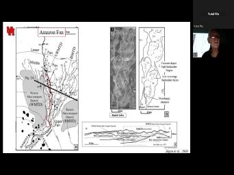
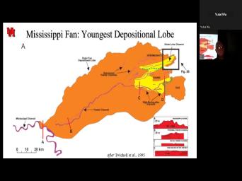
| 82:25 | of the Amazon submarine fan system over , particularly the upper fan. Let |
|
| 82:35 | just add for a second. This area here. Oops. And here |
|
| 82:45 | are mass trans big slump ed Ok. Here are channel levee |
|
| 82:55 | Here's the outer fan, your lower . And what we saw were meandering |
|
| 83:02 | of different ages. Uh Basically this the youngest And there was this one |
|
| 83:09 | there was this one and there was one and this week, this |
|
| 83:13 | So we've got what is analogous to distributive system, but it's a submarine |
|
| 83:26 | . Ok. And so we can to look at these and take a |
|
| 83:34 | of cross sections. And so here see each of these meandering systems has |
|
| 83:45 | funny kind of smiley look or gulling . That's what we saw in the |
|
| 84:03 | family. Um This is called the , uh and this is the |
|
| 84:18 | Ok. Now this package is repeated and over and over. Ok. |
|
| 84:24 | As these fans or as they channel sequences shift their location by a |
|
| 84:35 | Ok. So here's one chap, another chimp, here's another chimp. |
|
| 84:43 | . Now I'm gonna look right here most street. Oh, by the |
|
| 84:47 | , these are mask transport complexes. . OK. This is the Amazon |
|
| 84:57 | now what we have a deep sea cores uh to get a feeling of |
|
| 85:04 | some of the mythologies are that lower or sheet, which is analogous to |
|
| 85:17 | early low stand Sandri basin floor fan uh is, is called the heart |
|
| 85:28 | amplitude reflection package. And these things when, when you look at |
|
| 85:34 | the E logs, you see there's lot of thick amalgamated sand sand packages |
|
| 85:40 | to 35 m thick. OK? you have the channel it faces itself |
|
| 85:48 | this is the has high amplitude the hard and they're gonna be more |
|
| 85:55 | , but they will include some good good uh sands. And then finally |
|
| 86:02 | get the levee and over back, is low resistivity faces that are basically |
|
| 86:08 | thin bedded course and fine material. we're gonna look at a lot of |
|
| 86:14 | about this, but we could only one call on the Amazon. So |
|
| 86:23 | have to go to onshore analogs and densely drill levies to, to fill |
|
| 86:30 | the blanks here. OK. So the Amazon fan, here's that |
|
| 86:42 | here's that vertically accreting channel levee complex notice on underneath it is a mass |
|
| 86:52 | complex. OK? The in this area, the slump is the greatest |
|
| 87:07 | but More sandy deposits are almost 30% this section. So let's look at |
|
| 87:16 | in map view, we got these summary channels. We've got laterally accreting |
|
| 87:26 | cutback point bar. We even have off loops. We've got slumps, |
|
| 87:34 | got something in channel bed forms. other words, when people started looking |
|
| 87:41 | these things doing time slices, they to apply seismic geomorphology and say, |
|
| 87:47 | know, these things are amazingly like streams. You can apply the same |
|
| 87:53 | of geom morph characterization to them. as we'll see with significant differences as |
|
| 88:00 | , but one of the things is do migrate laterally so we can look |
|
| 88:05 | it here and look at uh this here, low direction. OK? |
|
| 88:22 | what we're looking at here, here's sketch of what that was when you |
|
| 88:31 | this, you think sweep or rather it's called uh in submarine fans. |
|
| 88:43 | you see this for this, you swing. Now we've talked about that |
|
| 88:59 | as translation and expansion. I wish could use the same terms, but |
|
| 89:04 | are describing the same style of migration , accreting packages of uh point bars |
|
| 89:15 | deeper water gravity flow deposits and even me under cutoffs banded channels. |
|
| 89:31 | So here basically is looking at the in which these things migrate. |
|
| 89:39 | when we're talking about rivers, we at a similar fluvial systems. We |
|
| 89:48 | something at my Saints Adams in Indonesia were fluvial and how we could use |
|
| 89:55 | seismic pattern of the of the point deposits to get a better feeling for |
|
| 90:02 | connectivity of sand deposits. And we do the same thing here by looking |
|
| 90:09 | the pattern of migration to see how potential reservoirs and seals are connected through |
|
| 90:21 | . So here, for example, that laterally migrating package? OK. |
|
| 90:31 | I remember talking to a a shell Back in the early 70s saying, |
|
| 90:37 | know, we we can actually see the high resolution the laterally accreting |
|
| 90:43 | He was actually thinking about fluvial deposits And I said, show me I |
|
| 90:50 | see this and I had to wait 30 years. Um but here we |
|
| 90:59 | a departed system. I'm sorry. This is a point bar. This |
|
| 91:11 | a, I honestly can't remember if is a fluvial system or not, |
|
| 91:19 | this, by the way, is of the answer to your homeworks whether |
|
| 91:24 | exam too. Uh this is its accretion. This is what it looks |
|
| 91:29 | in more detail. OK. one of the differences though is the |
|
| 91:38 | of those laterally accreting packages. In cases, their alternation between high concentration |
|
| 91:51 | and low concentration turbo. Notice in case, they, they merge |
|
| 92:02 | they're muddy all the way to the here. It's amalgamated high concentration, |
|
| 92:11 | density uh turbidity currents. OK. this is one major difference. I |
|
| 92:19 | if I asked you to compare laterally rivers with deep water meander shells, |
|
| 92:32 | is certainly part of what differentiates those packages skip this. Here are just |
|
| 92:42 | pictures. Field examples from the Jackson in Arkansas of that lateral accretion and |
|
| 92:54 | of the lateral variability. And uh in seismic. OK. Notice |
|
| 93:05 | here, there's a little dark zone underneath the high amplitude, that little |
|
| 93:13 | zone is mud and then that right fill is sandy. one of the |
|
| 93:23 | that often happens both in rivers and and when they ceased the meander and |
|
| 93:33 | submarine channels, when they cease to , they began to have mud deposit |
|
| 93:38 | they may still have one last deposit . But that's important because as we're |
|
| 93:43 | see in one of the field examples mud becomes a barrier to keep the |
|
| 93:49 | wet, but the laterally accreting deposits the levies which aren't shown here uh |
|
| 93:57 | producers. Now here is lateral accretion our Yeah, here is lateral accretion |
|
| 94:11 | seismic notice. There's vertical and lateral at some point, they often begin |
|
| 94:23 | become stabilized and they just accrete they quit meandering, not clear |
|
| 94:30 | but that's often seen. And then a channel abandonment but kept. But |
|
| 94:36 | is what it would look like in size we want. And here's the |
|
| 94:49 | about the ended channel, there's that bright spot right there. Uh But |
|
| 94:54 | mud, it separates the, this from the levee deposits. OK. |
|
| 95:02 | that'll be important later. And also how much topography is still preserved by |
|
| 95:10 | draping. And the last thing you a little sand here, this is |
|
| 95:22 | inversion of topography as the sand doesn't as much as the mud on either |
|
| 95:30 | . So what was this? It that? So this picture here, |
|
| 95:48 | this is lateral migration from below and vertical migration above. Yeah. The |
|
| 95:55 | with this three dimensional diagram is it it doesn't show any down current translation |
|
| 96:07 | the axis uh or rather the, sines is simply increasing. So this |
|
| 96:22 | be a an example and I'm gonna expansion because it's all I can |
|
| 96:29 | Um The way I want you to about this is this is one example |
|
| 96:37 | how these channels may migrate through If they're migrating through expansion. I |
|
| 96:44 | you to also imagine how they might through time if they I did it |
|
| 96:55 | translation. And lastly give some thought how the submarine channels change imply um |
|
| 97:11 | talk more about this transition of this in the levies later. But this |
|
| 97:21 | kind of the example vertical A This is a fluvial system. Now |
|
| 97:33 | did look at a creating systems chances cross sections. Channel F we had |
|
| 97:41 | rate versus rate of lateral migration versus of abul. OK. So we |
|
| 97:48 | there can be changes OK? But the short term, there's not nearly |
|
| 97:55 | much vertical accretion relative to the rate lateral migration, usually the flu systems |
|
| 98:09 | discontinuous. So that's one of several that you could be thinking. Also |
|
| 98:18 | about the levies and think about what the height, both of the channel |
|
| 98:24 | the levee. Is it gonna be full discharge or is it gonna be |
|
| 98:28 | thickness of the turbidity? Those are different dimensions now, in channel bed |
|
| 98:38 | . Um Well, we, we they existed uh because we've got these |
|
| 98:43 | of high amplitude reflectors in here, it wasn't really clear what they might |
|
| 98:49 | . Uh And it still isn't always . But when we look at the |
|
| 98:54 | Canyon example, again, we had sediment waves that were small when |
|
| 99:04 | enlarged when they were unconfined. And here are in channel bedford that our |
|
| 99:17 | flow regime and in which sand and does deposit and they're associated with hydraulic |
|
| 99:28 | . They form small scale bed forms large scale bed forms depending on whether |
|
| 99:36 | not, it's in a confined channel on a larger unconfined surface, either |
|
| 99:45 | a lobe or a levy. And are some of these sand wave or |
|
| 99:51 | sediment waves that migrate upstream up flow . Pardon me, uh that have |
|
| 99:57 | recognized for a long time. And fact, in some cases represent contour |
|
| 100:06 | and we'll just skip that. So the channels are meandering and by the |
|
| 100:13 | , the channels can be relatively straight too, we'll talk about that transition |
|
| 100:19 | , but there's also over bank Ok. So let's look at those |
|
| 100:25 | bank deposits, look where they're for and particular, look at this |
|
| 100:43 | this area in this area, it's the outer bend of a meander |
|
| 100:54 | I'm gonna come back to this, gonna reinterpret this uh to be contour |
|
| 101:02 | these, the reworked levies and uh uh that wasn't in the original |
|
| 101:16 | They certainly are sand waves, upper regime. Um This is a fault |
|
| 101:23 | . Ignore that, but we'll come to that idea. I want to |
|
| 101:27 | on these and these are, are spillovers where the upper part, less |
|
| 101:43 | turbidity current, the low density or concentration of turbidity current ends up spilling |
|
| 101:49 | the levee when there's a turn and the more dense flow. So we |
|
| 101:58 | what we call flow stripping and we progressively stripping the upper part of that |
|
| 102:08 | of turbidity current of the minor material then we get this amalgamated, thick |
|
| 102:17 | , thin bit to mud stones over . OK. So some of these |
|
| 102:26 | can still have enough sediment to be . But the most dense high concentration |
|
| 102:35 | turbidity currents are still confined to the . So here we have these san |
|
| 102:44 | units. OK. And they're pro potentially productive. Yeah. So here |
|
| 102:53 | these wash over lobes. There may some crevasse plays. Here is the |
|
| 103:01 | and again, this is here, is that older park that older Dan |
|
| 103:17 | are some examples again of sand Um I would simply add that at |
|
| 103:24 | some of these are probably rework We see him all over including the |
|
| 103:32 | in Nigeria where they been recognized forever being migrating upstream. But um it |
|
| 103:45 | only recently we started to record them these would be the more distal port |
|
| 103:52 | these would be analogous to the more portions of contours. And I don't |
|
| 103:58 | that you can tell the difference uh discal conor and distal lev except geometrically |
|
| 104:06 | currents and in a larger complex. these levies are in some cases, |
|
| 104:14 | reservoirs, sometimes called low resistivity They're a major architectural element in large |
|
| 104:22 | systems and actually smaller fan systems as . And they are associated with other |
|
| 104:31 | uh potential uh faces including channels and underlying uh harps or underlying lope |
|
| 104:42 | I just mentioned in passing, there crevasse plays So here's one of those |
|
| 104:50 | , those plays can like rivers begin be more long lived and here's that |
|
| 105:00 | lobe and as that lobe is that then becomes that lower heart |
|
| 105:08 | Ok. Uh We can do time to actually look at the growth of |
|
| 105:17 | crevasse play just as we took time to look at the growth of |
|
| 105:23 | Mississippi Delta play. Yeah. Now, here to reiterate, we |
|
| 105:35 | that low stand fan sand rich, have that more recent, more muddy |
|
| 105:48 | . So if you draw a cross right here, this is what we |
|
| 105:55 | . The lower fan harp. Notice chaotic debris flow underneath, come back |
|
| 106:04 | that channel levee system, debris flow fan love. That's what we saw |
|
| 106:29 | the Amazon. That's what we see over. And the suggestion here is |
|
| 106:37 | the initiation of a channel sequence is preceded by a mass transit um mass |
|
| 106:45 | complex which suggests Slum Canyon early Fan channel system abandoned. That's the sequence |
|
| 107:03 | I mentioned on the first slide. . And this is the pattern of |
|
| 107:10 | that we see from that sequence. , if we look at this, |
|
| 107:18 | channels or this cross section here, what we're seeing here. Um Here |
|
| 107:26 | got a channel, it's cut out . Here's a mud Drake you can |
|
| 107:38 | here is the ARP. This is frontal display. Here's the mass |
|
| 107:54 | here's the levee and this turns out be another debris. We'll ignore |
|
| 108:03 | Look at the E logs and the . I mean, I'm sorry for |
|
| 108:15 | Levy Chim. It's very diagrammatic but , it's a pretty good reflector on |
|
| 108:26 | way in which the sand is packaged is a relative measure of potential quality |
|
| 108:34 | the reservoirs. If we look at levees, one more thing, we |
|
| 108:41 | a surprising amount of slumping even though a very low relief feature. Although |
|
| 108:49 | can be slumps on the interior, proportion of the levee. And we |
|
| 108:55 | get these types of thin bedded not quite sure what they are. |
|
| 109:02 | were just named by what they look . Turns out uh here's a picture |
|
| 109:06 | some turns out, these are almost in most cases or in many |
|
| 109:10 | contour rights. So again, Levi contour rights, these are gonna be |
|
| 109:16 | proximal levy and proximal contra may be to tell apart if we look at |
|
| 109:23 | Mississippi fan, um entrenched middle fan lower fan. OK. There are |
|
| 109:47 | the let say this channel system, in the upper part, has not |
|
| 110:03 | laterally too much but has vert vertically through multiple cycles of Glacis static cycles |
|
| 110:11 | fall of sea level. Now notice as we get down into, we're |
|
| 110:22 | look at say three, four in , these are the most recent deposits |
|
| 110:33 | stage. one channel is wide, is narrow and sinuous. OK. |
|
| 110:46 | we're getting is a increase in sines a decrease in width. This is |
|
| 110:55 | many ways analogous to a great its . In any case, the channels |
|
| 111:02 | overlapping, if not an estimating this integrated into a meandering channel levee |
|
| 111:13 | . This sequence is really common again over the world. Now, if |
|
| 111:20 | go a little below this sequence, actually get gravels. So literally 1000 |
|
| 111:29 | offshore, we're getting gravels being transported some of these oldest lowermost grav uh |
|
| 111:39 | . OK? Now, we know lot about OK, the um Deep |
|
| 111:49 | system by looking at uh Africa and particular, looking at the *** delta |
|
| 111:57 | it has a whole series of the channel systems and we're gonna look at |
|
| 112:02 | right here. It's the ban in channel. Mhm And this system |
|
| 112:20 | we're gonna look at a cross section there's an older channel that was um |
|
| 112:31 | by evolution, think of the OK. Uh But let's look at |
|
| 112:37 | system right here. Here's the channel is actually within it. Some |
|
| 112:56 | an excavation and what I want to on is right here, lateral |
|
| 113:03 | the upper mood and then tail OK. So we're gonna start looking |
|
| 113:19 | this transition from here up here and particular, look at the meandering system |
|
| 113:34 | the inner levies and slops. You this kind of arcuate sides over |
|
| 113:44 | These are all individual slopes. Now, we can trace individual river |
|
| 113:56 | . And when we do that, see that the lower course as a |
|
| 114:02 | of superimposed low stenosis streamss may be as we go higher and higher up |
|
| 114:13 | increases, wavelength increases radius of curvage . That's the Mississippi all over. |
|
| 114:28 | . If we go down to we can look at some channel |
|
| 114:36 | Uh I forget which one it I think it's this one but it |
|
| 114:39 | matter. The green channel complex did same thing. You can look at |
|
| 114:46 | youngest and you can actually see all laterally accreting uh laps when you say |
|
| 114:53 | cutoffs. But we can also look it through time from here to |
|
| 115:08 | Straight crested, straight crested is Angola , Mississippi. Other areas as well |
|
| 115:22 | pattern of evolution of those channels as a grading is reflecting the change in |
|
| 115:33 | amount of bed load to suspended That's what Galloway I think was thinking |
|
| 115:41 | he talked about the effect of sediment on channel morphology. OK. We've |
|
| 115:50 | channel levee systems all over the They just differ in size. Here's |
|
| 115:57 | , we're gonna look at that Let's go from Mexico, the |
|
| 116:02 | Zaire, Rome Amazon be they're just literally everywhere. And basically, |
|
| 116:13 | a canyon, there's an channel levy with an outer levee and an inner |
|
| 116:21 | belt in a terminal mode. This our kind of mental framework. And |
|
| 116:30 | look at that transition here here. here's our base a lobe, here's |
|
| 116:41 | channel, here's our outer levy. . In the channel film, this |
|
| 116:53 | the story eight. Here we got up here. It is interpreted. |
|
| 117:11 | things all begin to look alike because similar process like saying all meandering rivers |
|
| 117:17 | to look alike. They don't but they have so many similarities, |
|
| 117:21 | can combine them. Now, this diagram is from Morse and is based |
|
| 117:30 | on crop da. But it's an to um provide mythologies in sedimentary structures |
|
| 117:47 | a context based on seismic. So it's a big the channel and |
|
| 117:59 | levy. Look at those, those the valley and they migrated laterally then |
|
| 118:13 | , we've talked about that. And the canyon, we have these larger |
|
| 118:25 | levies and then we got local breaches Reba blades, sand waves on the |
|
| 118:33 | on the levees. Mhm. So , let's see what those might look |
|
| 118:43 | . This is a little more detail . Let me look at this one |
|
| 118:51 | . OK. Here's the channel OK. We'll talk about what that |
|
| 119:01 | there. I wanna focus right now and it's gonna be basically sandy deposits |
|
| 119:06 | la laterally migrating deposits. Let's look the levee up in here. |
|
| 119:15 | let me go to here. We've got this levee growing like |
|
| 119:27 | That's what this is showing here. got a couple of little crevasse plays |
|
| 119:35 | here. We got some sand waves in here. Here, the |
|
| 119:41 | there's some slumping that's going on. local slumps on the margins here because |
|
| 119:51 | steep, particularly where there's a cut will have a mass transit deposit at |
|
| 119:57 | base of it. We see this in meandering stream today where the cutback |
|
| 120:04 | in that slump, then is found the bottom of the channel. We |
|
| 120:11 | those uh or rather, we saw in the canoe formation where there are |
|
| 120:16 | big chunks of over back deposits, fell into the base of the channel |
|
| 120:22 | slumping. That's what these are. can. So let's see what these |
|
| 120:30 | sheet are. OK. And in , we're gonna ignore a because a |
|
| 120:37 | the channels uh deposits the lapse and on the levee. OK. Um |
|
| 120:52 | got hetero lithic deposits. one through and that is, oh, I |
|
| 121:01 | to look at the color again. That's gonna be here. OK. |
|
| 121:10 | the more proximal parts of the levee hetero lithic we get up into here |
|
| 121:30 | the upper proximal, we're getting into beds four and five. The distal |
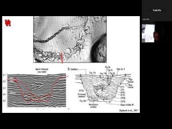
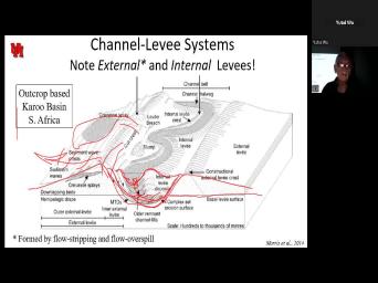
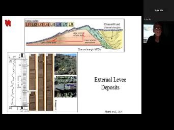
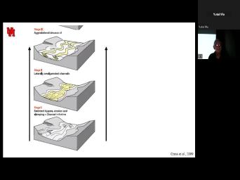
|
| 121:43 | down here. I I do that . I having a hard time seeing |
|
| 121:49 | the hetero lithic faces are down here the sandstones are full and then as |
|
| 122:05 | grade upwards, we get into silt . So there is a lateral and |
|
| 122:18 | vertical change in the levee. I'll this again while I can explain it |
|
| 122:24 | little better. The lateral change goes proximal to distal and that's course to |
|
| 122:33 | , the vertical change is going to going from or to five course to |
|
| 122:52 | . So I was both finding upwards finding distantly, OK. Some variations |
|
| 122:59 | the theme might be these rework sand which increasingly we're seeing as possible. |
|
| 123:06 | Rs. OK. So here's the levy and we can break it up |
|
| 123:14 | the proximal part, upper and And that's gonna be coarser to find |
|
| 123:25 | distal portions is going to be interbedded lithic. So here we've got that |
|
| 123:41 | to find, to verify crevasse plays . Um Here sediment waves could be |
|
| 123:52 | , abandon channel drinks. OK. is a a pattern we see for |
|
| 124:01 | external levies both vertically and laterally and the sand waves. Well, we've |
|
| 124:08 | them before. This is what a wave may look like an outcrop. |
|
| 124:15 | wonder we can't see it. They're distinct in seismic, but they're so |
|
| 124:22 | and even these are large. Um the wavelength here is on the order |
|
| 124:31 | maybe 100 m at most. Oh like tens of meters. They're clearly |
|
| 124:40 | upstream but they may, they may be the flank. You may be |
|
| 124:47 | looking at this. Yeah. So not gonna see these in the |
|
| 124:56 | OK? You may see a channel right in here, cutting the |
|
| 125:05 | OK? And if you look at , yeah of the lower proximal |
|
| 125:18 | yes, binding upwards. And the is finding upwards is because when it's |
|
| 125:31 | formed, the canyon and channel were and so the coarser material could spill |
|
| 125:42 | so that we get course external That's right here. As that levee |
|
| 125:55 | , it cuts out more and more the turbidity current. So we're getting |
|
| 125:59 | and finer finding. OK. that implies that the canyon in which |
|
| 126:14 | turbidity currents or filling has continued to even as this channel is migrating, |
|
| 126:34 | is here, we have a migrating down here. So the outer channel |
|
| 126:47 | been around and is a larger scale older feature sense than is the channel |
|
| 126:56 | Neanderthal complex. That's why there's an led the in and outer look. |
|
| 127:02 | outer levee is where the canyon is spilled over as the canyon fills, |
|
| 127:10 | still canyon spill. So the outer continues to grow. It's just finer |
|
| 127:19 | . But now the canyon is filling a uh meandering channel which is consisting |
|
| 127:32 | the coarser material, the lower part the current. Now, another reason |
|
| 127:40 | it might change vertically is if the are moving laterally, this is more |
|
| 127:48 | of the inner levee, but maybe because there's a here and if you |
|
| 127:54 | it through here, notice how here's channel channel binding upwards. That's because |
|
| 128:03 | lateral migration. So both lateral migration vertical oh are shallowing of the depth |
|
| 128:18 | or rather increasing of the height of levies is a function or, or |
|
| 128:24 | will control the levee change. this is what I was trying to |
|
| 128:29 | . And I meant to show this notice, even when this canyon is |
|
| 128:35 | , you've got a little bit of and as it continues to migrate due |
|
| 128:45 | meandering that levy continues to grow. here's a laterally migrating channel and it's |
|
| 129:00 | have an inner levy and here it's moving laterally, but it could accrete |
|
| 129:07 | as well. And this is a model, but it works. Here's |
|
| 129:14 | channel, here's the slumping that's Here's that outer external levy. Here's |
|
| 129:28 | internal enter levies as that channel is at the same time as that outer |
|
| 129:50 | is growing. Ok. So here's inner levy and the outer levy. |
|
| 130:00 | . And here's what it looks like a seismic way. OK. It's |
|
| 130:15 | , but it's actually not. If generalize it, you've got these outer |
|
| 130:23 | growing from the beginning early on to end. As long as there's turbidity |
|
| 130:31 | current high enough to overtop it. the levees grow up, the overtopping |
|
| 130:38 | finer and finer grain. The canyons gradually filled with meandering channels that are |
|
| 130:47 | in S S as they get more more money because sea levels beginning to |
|
| 130:58 | and they can no longer, they it earlier over that low shelf. |
|
| 131:04 | mean that low fan, but now beginning to back right beginning to grade |
|
| 131:11 | and fill the channel with fine and material. Ok? And so this |
|
| 131:17 | just kind of a model that bears at at your leisure. Ok. |
|
| 131:30 | gonna, I'm gonna leave the topic you need to spend some time concentrating |
|
| 131:35 | it. Now, here are some channels that turned out to be um |
|
| 131:45 | . Here, you can see the channel systems but they're in valleys. |
|
| 131:53 | here is the valley for one Here's the valley feel for another |
|
| 132:02 | OK. So we're just gonna look one of these, the Sequoia |
|
| 132:07 | That's this one here, I Ok. Oh And this is the |
|
| 132:18 | on we had a lot of segment , but they don't show what we |
|
| 132:25 | assume is there's gonna be an external here. Gradually the bypass begins |
|
| 132:32 | We get a amalgamated channels. It to grow up into meandering channels that |
|
| 132:45 | basically filled. Now, in this , we have a couple of meandering |
|
| 132:53 | . Yeah. Uh That's just a on the thing. So here's our |
|
| 133:01 | where the levies are, but here's massive channel breaking up into a couple |
|
| 133:09 | meandering channels, breaking up into isolated , filling with mud. Now, |
|
| 133:20 | is an idealized pattern from Africa. just left the Nile, we'll come |
|
| 133:26 | to it. OK. The idea channel incision. A canyon incision rather |
|
| 133:34 | , maybe a debro was and channel maybe re incision. Finally channel the |
|
| 133:48 | levy and that's something like what we here. Now, let's let's kind |
|
| 134:01 | break it up in even more simpler . Uh bypass. So maybe a |
|
| 134:09 | growl slops high net to grow stack fill. That's gonna be those wide |
|
| 134:23 | chants grading up into lower net to channel Lee complex. We just, |
|
| 134:34 | can envision that going up to the until finally we get into very high |
|
| 134:44 | top most channel, low sanity, sanity, high sanity, low |
|
| 134:53 | high mud. Hi, Sam. , Sam. Ok. That's the |
|
| 135:03 | turns out this, this mile, turns out this miles all over the |
|
| 135:13 | . The other thing to keep in is that's just one incision fill event |
|
| 135:21 | this one or this one or these things can feel larger canyon systems |
|
| 135:35 | time. Ok. So each of is going to be one of |
|
| 135:55 | And so what we can think about kind of complexes where you've got, |
|
| 136:11 | channel feels upward. And then the channel sitting up here, the, |
|
| 136:29 | individual channel is something pretty small that's be in here. Oops, what |
|
| 136:44 | pin is good working. But you the idea of, um, I |
|
| 136:48 | my cursor that individual channel is gonna right in there. Ok. And |
|
| 137:01 | here we've got something for Angola. , now it's gone from West Africa |
|
| 137:09 | Angola. Uh 2018. Uh, now at least can say what country |
|
| 137:14 | here and I think you can see lateral change in these OK. That's |
|
| 137:24 | . Uh these canyon fields because these are long lived features that will be |
|
| 137:32 | conduits over long periods of time, sea level changes. And so these |
|
| 137:39 | lobes uh may also show the the , not only of a lobe covered |
|
| 137:50 | mean channels, but then abandonment, , meandering channels abandoned. So each |
|
| 137:59 | those systems here, he's going to a evil low growth pattern down, |
|
| 138:12 | slow. Is that OK? Let's it what's we can stop the |
|
| 138:21 | OK. Uh This is our We're looking at deep water centers. |
|
| 138:34 | And let's do some variations on the . Uh Suppose, for example, |
|
| 138:41 | have some kind of bath metric uh that causes an area to pond. |
|
| 138:52 | could be a slump or it could uh I any number of things. |
|
| 139:01 | what it will do is give us is an intra basin loa as supposed |
|
| 139:07 | a basin floor load. And a of our reservoirs uh are particularly |
|
| 139:15 | on mobile substratum are actually not base lobe, but rather intraloop lobes. |
|
| 139:22 | . Now, also notice is coming of a confined area into a |
|
| 139:29 | but it seems to he actually course find. So let's look at this |
|
| 139:38 | um moody described a jet in which had erosion and of course uh rain |
|
| 139:52 | sorted sandstones that extended into an area proximal distal lobe. And that is |
|
| 140:03 | course, what was also shown with uh turned out moody uh had been |
|
| 140:09 | to some of the Exxon work and , was reflecting that uh in anticipation |
|
| 140:15 | publication. So we see here that , bed load deposition, suspended load |
|
| 140:25 | proximal to dis OK. Now let's a cross section here confined to |
|
| 140:35 | Yeah. Now we're coming through, is down in here high density, |
|
| 140:42 | density turbidity current, hydraulic jump lots turbulence as this thing begins to spill |
|
| 140:54 | . And it's basically gonna be we get a supercritical type of turbidity |
|
| 141:04 | and resulting herd as that transition And we can describe it, we |
|
| 141:11 | look at the back sets scows and also think about where it would |
|
| 141:19 | It's gonna occur any place where we from, confined to unconfined and confined |
|
| 141:34 | under unconfined. And in my we've got these fingerlike lobes, we've |
|
| 141:43 | the channel and these funny scalps. it turns out that in some cases |
|
| 141:55 | transition actually this here the transition is zone for break of slope to the |
|
| 142:05 | and it scoured the dunes could be , ridge dukes and sediment waves. |
|
| 142:14 | this is one of those cases where actually do see dunes forming in sub |
|
| 142:20 | systems. I mean, uh so deep water systems channelized levee expansion. |
|
| 142:37 | . Now it turns out that and think I talked about it. |
|
| 142:41 | Urbanites can be subdivided based on how they are in extending long distances. |
|
| 142:53 | a low efficiency turbo system is sand , low volume. Well, it's |
|
| 143:01 | low volume lobe. It's a Sandri mud, high efficiency, higher |
|
| 143:11 | more mud and most efficient is kind a mud dominated system. Now, |
|
| 143:20 | happening, the more mud you've the less viscous, the turbo is |
|
| 143:29 | of a low density turbo or low and the farther it will flow whereas |
|
| 143:37 | dense, uh, high concentration permitted with no mud, it's just gonna |
|
| 143:45 | . OK. Now, what that is that this area, this channel |
|
| 143:51 | transition can get increasingly wide. Um using wide in different terms. This |
|
| 144:07 | Um, 15 - 20 km I gotta redo that. OK. |
|
| 144:14 | here we've got media dump, scour with uh sediment here. Bypass high |
|
| 144:30 | , low efficiency. So this channel channel lobe transition zone, sometimes C |
|
| 144:41 | T Z can be seen in crawl fault here. And these are the |
|
| 144:58 | and this is the, the, model, OK? That we go |
|
| 145:11 | . I just, just skip It's too hard to explain the time |
|
| 145:14 | . But this is what you could that zone bypass looking like over time |
|
| 145:26 | the accretion of that proximal low. . And again, that's where we're |
|
| 145:33 | at here and here now that scour which includes not only erosion but |
|
| 145:47 | um, um, do like uh will, will alternate a lot |
|
| 146:00 | an Alluvial fan, it's got it from it channelized, unch channelized. |
|
| 146:11 | a lot of the work that's been is relating the flume work of fans |
|
| 146:19 | the inferred flume work of lobes where backfill, flip, backfill, flip |
|
| 146:29 | lobe flipping. OK. Uh I'll you read this at your leisure. |
|
| 146:34 | basically characteristics of these transfer results. . What I want to focus on |
|
| 146:40 | is where those that transition goes from to low. Now, this is |
|
| 146:47 | Congo, this is the channel floor this is the levy crest. Now |
|
| 146:55 | the levee gets lower and lower until merges with the bottom. That is |
|
| 147:03 | said the channel, the levees And at that point, you have |
|
| 147:11 | flow. So here we have those crests in the channel. OK. |
|
| 147:19 | we have the end of the the beginning of the lo. So |
|
| 147:28 | look at something more like a hypothetical uh look at the levee height. |
|
| 147:38 | a second. Um I can't just . OK. Yeah, there was |
|
| 147:50 | to be a line here which is this line here. Um This |
|
| 147:57 | Yeah, yeah. This line here a channel bot. Here's the levee |
|
| 148:04 | , here's the total flow. So density, high density turbidity current. |
|
| 148:17 | this is the channel bottom, levy , channel bottom like the height. |
|
| 148:27 | , right at this point, I've this to the point where the levy |
|
| 148:34 | goes to zero, you know. yeah. I'm sorry. I, |
|
| 148:49 | mean this is the bottom of the , sorry. Yeah, we'll see |
|
| 148:57 | this is in. OK. And is the top of the float levy |
|
| 149:08 | , chow, bottom, top of slope. This is what I was |
|
| 149:14 | around to this. Here is the high density, low density to be |
|
| 149:39 | , can't get this work. Now that turbidity current goes down flow, |
|
| 149:56 | a process of alleviation that causes the grain materials to float to the top |
|
| 150:04 | it spills over any time. The of the levy is less than the |
|
| 150:12 | of the turbidity occurrence. Their spillover lea growth and the turbidity current gets |
|
| 150:22 | and smaller distance. Now, the or height of it high density turbidity |
|
| 150:33 | really doesn't change much but look what right here. The high density turbidity |
|
| 150:46 | begins to spill over. There may still be some levies and there's this |
|
| 150:50 | not what I implied earlier where the and levee disappear, but rather it's |
|
| 150:57 | the levee is lower than the height the high density turbidity current. Say |
|
| 151:07 | fast real time. Uh you drive you crazy. And what that |
|
| 151:13 | is that the percent sand is gonna right about here. This is where |
|
| 151:25 | levee begins to uh or rather the begins to form a sandy lobe. |
|
| 151:34 | , this is a transition point, so much from the channeled that but |
|
| 151:40 | where the height of the levee is than the effective flow or height of |
|
| 151:46 | high density component in that transition will the deposition of a band where uh |
|
| 152:04 | , it'll have that transition be How do I say it closer to |
|
| 152:13 | land if the levee is not very and the Hi den morbidity current is |
|
| 152:27 | high relative to the levy levee. gonna be where you have a high |
|
| 152:31 | of mud system. Think low standard sea level think that lower Harp think |
|
| 152:44 | lower system where you had a sand float fan or basin boat fan. |
|
| 152:50 | look what happens to that transition point the flow turbidity current gets finer |
|
| 153:01 | less sand, more silt. It's seaward. Then finally, it's way |
|
| 153:09 | here. So now we've got this system migrating on top of the fan |
|
| 153:22 | . So here we have transition point low sand transition point I see. |
|
| 153:33 | this is the model that I want to think of. When you think |
|
| 153:37 | this transition, this frontal display, harp and all the details that we |
|
| 153:46 | about in here. Here's that final actually, let's look at it over |
|
| 153:57 | . Here's that transition unit here we that frontal display here, cross |
|
| 154:21 | So basically, this is what we've talking about for some time. This |
|
| 154:28 | here really this to this. So happens when it becomes unconfined? |
|
| 154:40 | we've already talked about the fact that is in a low flow system, |
|
| 154:44 | mean, low sand system, high system, there's a channel levy transition |
|
| 154:55 | . Let's ignore that for a second think about the depositional upload. It's |
|
| 155:03 | described as an access to French. it's a, it's a bit misleading |
|
| 155:12 | we really have these lobes, little elements forming a lobe lobes forming lobe |
|
| 155:27 | and then lobe complex sets sounds very like what we talked about with the |
|
| 155:36 | fly in the jet deposits. These represent short term deposition, depositional elements |
|
| 155:47 | a crate into larger and larger low . So let's look at that lobe |
|
| 155:56 | the low stand here, it was the low stand and here it was |
|
| 156:04 | the higher stand, I say higher . Um when you had the meandering |
|
| 156:16 | covered, OK. Now let's look that upper low and we see that |
|
| 156:23 | consists of a series of lopes and are uh you can't quite see him |
|
| 156:29 | , but you begin to see him packages and I'm just gonna take seller's |
|
| 156:40 | for it. Uh that this, are the packages that form the |
|
| 156:48 | Again, this is just a one of sea level uh pack it in |
|
| 156:55 | here and you can see with the in detail, the information you get |
|
| 157:04 | packet K. Well, it is it's some place. OK? Again |
|
| 157:12 | . OK. Here's that low K a little portion of the larger |
|
| 157:23 | Here's Kay again. And if you carefully, I think you can see |
|
| 157:31 | channels. All of that is part K which is part of the whole |
|
| 157:49 | . Here are again, some more . And Los Los, OK. |
|
| 158:01 | we see that little lobes form big which form big lobe complexes all within |
|
| 158:08 | single period of time in terms of package. OK. Uh If we |
|
| 158:17 | at these salt mini withdrawal basins we see the same thing. We |
|
| 158:26 | lobes, lobes lobes. And if look carefully, you can say distribution |
|
| 158:44 | . In fact, they look something this. So each of these is |
|
| 158:52 | little lobe packet, they had superimposed on top of another looks something like |
|
| 159:01 | . So this is in an intra . No, not a basin floor |
|
| 159:08 | , but it's the same packaging, same pattern of shifting. Uh Let's |
|
| 159:18 | to the Gulf of Mexico. Let's to this area here where we've got |
|
| 159:22 | whole series of basins. There are , many basins, salt withdrawal |
|
| 159:29 | basin, one to three and OK. When we look at one |
|
| 159:39 | those bases, we look at how feels. First thing that happened, |
|
| 159:46 | had a mass transport complex, then began to get dis tributary lobes and |
|
| 159:55 | and then it had his own bypass that lobe was covered by an overriding |
|
| 160:05 | channel complex. And notice the lobe like a finger like right, almost |
|
| 160:16 | . And that's because of these little . And this is something uh analogous |
|
| 160:26 | the what you might uh get, not gonna get into this. Uh |
|
| 160:32 | can look at it at your leisure you're interested about the vertical change. |
|
| 160:36 | the main thing is you go from trans transit to a channel lobe complex |
|
| 160:44 | load complex. And what's happening is a fill and spill. It |
|
| 160:54 | spills, fill, spills, fill and particularly during low stand, it |
|
| 161:02 | erodes. So during high stand, filling, the overflow is the relatively |
|
| 161:19 | grain upper portion of the turbidity currents the courses material being period at the |
|
| 161:32 | first oh first is to fill I'm later. If there's erosion going |
|
| 161:47 | you can get some coarser material. it could go here, capped with |
|
| 161:56 | erosion up here. So the pattern filling from top to bottom will change |
|
| 162:05 | on what the sediment supply is And one of the things unique to |
|
| 162:10 | Aly's gravity flows is that sub gravity can have a vertically stratified turbidity current |
|
| 162:18 | could be 100 m high with a grain portion below fine grain above. |
|
| 162:26 | of that tripartite subdivision we talked about the very beginning. Yeah. So |
|
| 162:34 | we've got a confined channel. It's up until finally spills over again. |
|
| 162:45 | fills up. This is an auto change. In other words, what |
|
| 162:53 | looking at here is the vertical change to a change in the proximity of |
|
| 163:03 | turbidity curve and then it spills over starts again. Here we've got an |
|
| 163:15 | lobe complex where we have changes in , upstream, up current sediment supply |
|
| 163:24 | by external factors will stand. He , for example, it gives you |
|
| 163:30 | cyclicity. OK. So we see an individual lo or rather within an |
|
| 163:40 | time period, autogenic changes and then time, externally driven changes. |
|
| 163:51 | And, and we see that in salt influenced Santo space, just like |
|
| 163:56 | many basins of the Gulf of they'll come in instead of just a |
|
| 164:03 | minded linear split like we saw in Gulf of Mexico doing all sorts of |
|
| 164:15 | . So this is the reality of really complex salt influenced that. |
|
| 164:26 | Uh And again, I'll just uh you look at that at your |
|
| 164:30 | but it shows you the, the that you get the Nile is |
|
| 164:38 | but it's the same story. Here's shale ridge causing ponding down here. |
|
| 164:49 | have that the unit is going from ridge to open. Here's a different |
|
| 164:58 | shall ridge open. Let's look at in detail, we see individual |
|
| 165:07 | So what looks like a axial to banning is really a series of these |
|
| 165:17 | lobes. OK. Skip this uh is a discussion about these intra slope |
|
| 165:26 | basin floor fans. I'll let you at that. Uh I don't want |
|
| 165:31 | go too much into that with the I had left. But let's look |
|
| 165:38 | the submarine fan system of the The this plane lower fan, middle |
|
| 165:45 | , upper fan, Lower fans, harp look at the percent month, |
|
| 166:00 | , mud, even though it's the distal part of the fan, 90% |
|
| 166:08 | Or 95% mud when you're up here the upper fan with the channel le |
|
| 166:15 | . So there are major changes as go and look at these fan elements |
|
| 166:22 | time. Now, let's look at meandering system ahead of the meandering system |
|
| 166:32 | a low. Ok. So each those meandering systems had a low and |
|
| 166:39 | pro graded through time. So here's series of them of these meandering pro |
|
| 166:51 | lobes that were eventually covered with the levy system. Now, this is |
|
| 167:08 | , older. This is that little time. One that's right about |
|
| 167:19 | And now the lobes are regressing and they're doing, they're filling this area |
|
| 167:32 | . They're backs stepping. This yeah, this is something we haven't |
|
| 167:35 | seen before. They're backs stepping because the rise in sea level. |
|
| 167:45 | Dingo fan lobes, Mediterranean fan the bigger lobes, the channel, |
|
| 168:02 | Congo here are some of those big . Here's the modern day basin floor |
|
| 168:11 | . Let's look at one of these , low, low, low, |
|
| 168:15 | . This is how it's extending itself with the basin floor fans, they |
|
| 168:25 | by theories of younger and younger They see it on the all the |
|
| 168:36 | bottom floor basin floor fans in in Bain floor. Same model that that's |
|
| 168:50 | a repeat that wasn't supposed to be . Here's the Mississippi, we're looking |
|
| 168:57 | one part of the Mississippi main Mississippi , an older channel lobes, |
|
| 169:07 | lobes, look at them in more , little bitty channels, little bitty |
|
| 169:17 | . We look at those and we tiny lobes. Yes, me and |
|
| 169:34 | can only see this detail because we're a high resolution scanner of of the |
|
| 169:42 | surface. That's basically what we see . So we see that the distal |
|
| 169:50 | of, we see that these lobes splitting up in smaller smaller lobes to |
|
| 169:56 | their tiny little child chimps like OK. So let's see how we |
|
| 170:04 | approach these from a reserve point of . I've shown you some examples of |
|
| 170:11 | with contours. Let's look at some using this model here, let's begin |
|
| 170:18 | the Gulf of Mexico and there's five that we could look at each of |
|
| 170:24 | represents production in a different portion of model that we talked about. So |
|
| 170:33 | look at the levies first think we this. Um So we have the |
|
| 170:44 | and associated reservoir fishes uh channels, underlying low. Here's our goal and |
|
| 171:00 | a channel and levy notice the levee coarsening rather fining upwards. Ok. |
|
| 171:15 | Globe Levy, all three are potential . The Tahoe field is basically a |
|
| 171:28 | . It thin beds, but they're producing is coarser at the bottom finds |
|
| 171:36 | because all of these little stringers are laterally. Yeah. What about |
|
| 171:49 | Well, I'll have to come back that. Um, these P slope |
|
| 172:02 | come through here, you know, some stuff but um always happens. |
|
| 172:22 | run out of time. Um Uh These are the main traps, |
|
| 172:27 | mean main um reservoirs and they're basically up uh the feeder channel and, |
|
| 172:38 | here's the lobe About 10 m thick it consists of a series of little |
|
| 172:50 | . There's other uh reservoirs in Channels mainly here. So this is |
|
| 172:58 | a channel fed a channel reservoir setting some uh lobes at the end |
|
| 173:14 | and uh the Congo basin and Angola big uh channel aggregate, we get |
|
| 173:25 | series of amalgamated channels. They are , they're in the lower part of |
|
| 173:34 | of these aggregation fields as we go up, we get into lobes, |
|
| 173:45 | as good reservoirs, but because of lobes or bath, the metric |
|
| 173:52 | we have compensation stacking. What we're at here is that model again, |
|
| 174:04 | reservoirs, moderately good reservoirs, no . OK. So that package the |
|
| 174:16 | time and time again, the LEVI in offshore Nigeria. Here's the |
|
| 174:29 | here's the channel, here's that here's that levy. OK. Notice |
|
| 174:40 | levee sitting on top of the OK. Congo, nope, just |
|
| 174:59 | we saw elsewhere. Little bitty fingerlike . So, so, so we're |
|
| 175:14 | at again, lobe reservoirs here in North Falklands, we talked about it |
|
| 175:21 | . We get these digitate globes within lobes. We have 13 lobes here |
|
| 175:33 | this basin, We have four rock , mass flow in T A as |
|
| 175:46 | inner lobe, low density turbo, outer lobe, mass flow debris, |
|
| 175:56 | fringe and non reservoir. The best are sitting here with the VMAS. |
|
| 176:05 | gonna be the proximal part of that low. It's gonna be the inner |
|
| 176:13 | of each of these groups. Here we've got again, the inner |
|
| 176:24 | , those little distribution channels thick oh deposits still good thick, what they |
|
| 176:41 | them hybrid here. Oh Actually, is uh going into grade deposits. |
|
| 176:53 | is the pro grading frontal lobe and see the distal decrease in that thick |
|
| 177:04 | turbo and lateral changes as well. this is the downstream pro gradation, |
|
| 177:15 | or down lapping of that package. this is the kind of lateral packing |
|
| 177:24 | against it. Compensation of hacking. go back to this. Let's go |
|
| 177:35 | to the top, which is a here. We got the channel fill |
|
| 177:46 | . We have a levee and lee . Now, the levee over |
|
| 177:52 | OK. You can kind of see the um e log vertical sequence. |
|
| 178:09 | are centimeter thick sand. So you don't seem like they would be |
|
| 178:13 | but they're producing wells. This is map of the, the field and |
|
| 178:26 | problem is most of the channel is . The production is mainly from the |
|
| 178:36 | . And the reason for that is there's a little bit of a down |
|
| 178:43 | here, a shale at the base the champ and that shale is just |
|
| 178:50 | to cut off the channel deposits. here's the production or the, |
|
| 179:00 | this better, here's our oil and or a gas and water. |
|
| 179:07 | oil and gas and gas on Oil on the bottom, right? |
|
| 179:16 | , yes. So, ok, Ram field, these are lobes and |
|
| 179:28 | at um series of overlapping packages. amalgamated cheat chat for Jay Allen M |
|
| 179:44 | Levy and Amal invaded Saints. You look at that later. Uh But |
|
| 179:55 | the levy and here's the chance the is in the levee. Here it |
|
| 180:05 | here. This portion here, this of the field is in the |
|
| 180:19 | Yeah, these are levy deposits. the channel wet and I meant to |
|
| 180:33 | this. This shows the oil in real thin um levy deposits and what |
|
| 180:47 | wanted you to see, but I to enlarge it is that proximal to |
|
| 180:53 | , fining upwards of the living. . Um Mars in the slope basin |
|
| 181:04 | here it comes in, it's being by a big salt dome. There's |
|
| 181:14 | field, I'm sorry. Uh here's field in yellow salt domes all around |
|
| 181:23 | uh being barrels of oil equivalent seven , the lowermost reservoir series of pro |
|
| 181:35 | lobes. And if you look at in detail, you see those little |
|
| 181:40 | lobes. Ok, amalgamated sands giving sheet sands. Now as it grades |
|
| 181:57 | , we get into more money systems more channelized systems, the upper channels |
|
| 182:11 | more narrow. Here's a low lower , think of it as your heart |
|
| 182:18 | then we get into the a grading migrating on top of the lobe. |
|
| 182:26 | the lobe is an amalgamated sheet sand these are some of the characteristics. |
|
| 182:34 | . Um MENSA sitting here is a of backs stepping lobes. Amalgamated sheet |
|
| 182:49 | that are backs stepping due to a in sea level is tilted uh because |
|
| 183:00 | uplift on so on marsh. Here's field right here and notice the lobe |
|
| 183:06 | this is an individual lobe but the are not always connected, but this |
|
| 183:15 | I think is disconnected. Maybe it's , these are amalgamated. You see |
|
| 183:20 | these lobes aren't always laterally connected and is just one of the areas |
|
| 183:42 | Oh, so it's laterally disconnected. . OK. Uh Amalgamated sand. |
|
| 183:57 | all amalgamated sands, but these are poses with little shale where you're separating |
|
| 184:03 | the um reservoirs and this is um channel cut out. Ok. Sheet |
|
| 184:18 | , channel sands and I'm gonna handle still Gulf of Mexico but supply. |
|
| 184:32 | same idea though older lobe, younger , each lobe consists of a series |
|
| 184:39 | little distributed lobes, the trunk. tributary here insists Over 70% Sandstone, |
|
| 184:55 | , massive sense, chas lobe, massive sandstone, low margin, |
|
| 185:05 | No. So let's look at a real might be something like this. |
|
| 185:12 | might be looking at the trunk, might be looking at the distal lo |
|
| 185:17 | completely different percentages of uh I'm Uh This is your field within that |
|
| 185:27 | . You've got areas that are 90% turbo deposits or den uh debris, |
|
| 185:35 | de uh herb s which are your reservoir to almost not OK. If |
|
| 185:43 | look at the permeability, the red distal, the blue approximately. Now |
|
| 186:01 | some blue that are pretty bad, the reality is your best reservoirs are |
|
| 186:07 | be here in the approximal area. . And part of it because they |
|
| 186:16 | are grained is you approximate the Part of it is because there's more |
|
| 186:22 | , the sandstones are smaller and more rich. This again looks at the |
|
| 186:30 | in grain size and the trunk channels are very good. The channelized lobes |
|
| 186:40 | almost as good. Low margins are very good at all. Now, |
|
| 186:47 | one other thing, the paleogene reservoirs not nearly as good as the |
|
| 186:58 | Now turns out MCE reservoirs are much quartz rich. 82% quarts, much |
|
| 187:12 | with the paleo and the rock fragments 20% vs about 2% here. Now |
|
| 187:30 | tells me there's a change in but there's also a resulting change in |
|
| 187:38 | porosity and permeability. You can look the convection curve for the my, |
|
| 187:47 | doesn't, it stays at 30%. at the compaction curve for the |
|
| 187:54 | it goes down to 20%. And because of the increasing amount of ductal |
|
| 188:04 | better volcanic. And so the quartz zones, sources are not, will |
|
| 188:15 | more of their primary porosity. Then the rock fragment rich. So zones |
|
| 188:24 | because of the ductal deformation, the of pseudo matrix are not as |
|
| 188:32 | And look at the variability of the composition in composition and grain size of |
|
| 188:44 | deep water reservoirs. The same variables impacted the flu system and flu reservoirs |
|
| 188:53 | the Deltec system and Deltec reservoirs in deep fan systems and deep reservoirs. |
|
| 189:01 | start with sources and continue through Di . OK. Now a lot, |
|
| 189:10 | one last thing I'll mention here. is the change in source. Here's |
|
| 189:17 | globe in China. The source did change. What's changing is the fabric |
|
| 189:25 | the texture of the different environments. system. We've got an low |
|
| 189:35 | a near access fringe. We already that those consist of a whole series |
|
| 189:41 | little, little bets. We know the high density turbos here are our |
|
| 189:51 | reservoirs and cous reservoir. They're also decrease in grain size and increase in |
|
| 190:01 | . Look at the permeability and the high density turbos, the low |
|
| 190:17 | turbo. OK. The reality is as we go and bury these |
|
| 190:28 | actually, I'm gonna skip it as go and bury these things, we |
|
| 190:32 | a change in porosity and permeability, because of the composition of the sandstone |
|
| 190:42 | , but because of the amount of in the grain size. So the |
|
| 190:47 | thing I'll end on is this statement Moo and it says case by case |
|
| 190:57 | without preconceived ideas that is models and based on careful core analysis, Integrated |
|
| 191:05 | 0D seismic and well logs has opened a whole new, Ran the phase |
|
| 191:11 | research in the industry and company in industry and academia. And I would |
|
| 191:17 | not only 0D but seismic human. current models are still heavily based on |
|
| 191:24 | driven depositional patterns. They're clearly particularly in terms of recent advances in |
|
| 191:32 | exploration. We need to begin to at some of the complexities, one |
|
| 191:37 | which is the role of turbo and fan systems. OK. So on |
|
| 191:44 | , that's all the time we There's lots more to this world uh |
|
| 191:49 | of mythology that you'll just have to on your own. But uh that's |
|
| 191:54 | for this course. So OK, think uh you could figure out that |
|
| 192:13 | there's a whole new, there could a whole course in each of these |
|
| 192:18 | . I used to teach a semester course Deltas and Deep Sea fans. |
|
| 192:25 | , so you've got the rest of career to teach yourselves and take advantage |
|
| 192:31 | any opportunity you got. But, , let me send you the, |
|
| 192:42 | , uh, uh, take home , um, let me, I'll |
|
| 192:51 | over it with you real |
|

