| 00:02 | good last lecture. And then we'll how the rest of our actual goes |
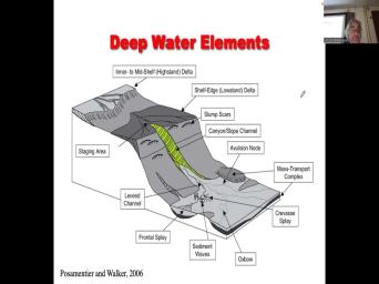
|
| 00:11 | questions about assignments. See how we . That's not too dark. |
|
| 00:21 | Mm hmm. Now, admittedly, not super expert on deep water |
|
| 00:31 | I say my PhD supervisor was very respected for his knowledge of deep |
|
| 00:38 | And uh, I worked pretty closely how many postmen tear. No, |
|
| 00:45 | know the community. Um and this sort of largely we're talking about source |
|
| 00:52 | sink a little bit again and how of how it's applied to deep water |
|
| 00:57 | and you know, kind of linking whole, the whole system together to |
|
| 01:01 | predictions about scales. And then Henry Material Roger Walker wrote a paper on |
|
| 01:08 | water in 2006. Kind of a . It's a little old, but |
|
| 01:11 | sort of summarize some of the key . But I think our takeaways that |
|
| 01:17 | us make predictions because, you fundamentally in the petroleum business, whether |
|
| 01:23 | the exploration business or the extraction business oil fields to make predictions about whether |
|
| 01:30 | not the reservoir is there, whether got oil in it, whether you |
|
| 01:33 | a work of petroleum system. And if you found it, what volumes |
|
| 01:36 | going to get out at what rates work with engineers to make sure that |
|
| 01:41 | keep the costs as low as Mhm. So just kind of a |
|
| 01:49 | slide. We've got, you in a in a continental scale |
|
| 01:54 | You've got the continental shelf what's very will, you know, this is |
|
| 02:00 | kind of slide, which, you , it's got a lot of |
|
| 02:03 | Some of them have ranges, Some them are just one number. So |
|
| 02:06 | continental shelf is the average width of kilometers. Obviously it could be |
|
| 02:11 | Uh, sometimes it could be a of 100 kilometers. You may have |
|
| 02:14 | of the, the 200 mile So the grand banks in Canada is |
|
| 02:19 | grounds. And some of that continental extends beyond the turnabout limit. That's |
|
| 02:23 | the card breed and of course because legally in international waters, the Newfoundland |
|
| 02:28 | fishery was destroyed both by excessive fishing the inshore and the inability to control |
|
| 02:35 | , folks from europe like the Norwegians particularly the Portuguese used to be in |
|
| 02:39 | john's every year, the massive fleet ships and they would come and take |
|
| 02:43 | call and take it back to And I remember taking the very first |
|
| 02:47 | in marine geology, taught at Memorial and we had to learn things like |
|
| 02:52 | law of the sea. And there's 12 mile limit, which is sort |
|
| 02:55 | a, that's more like a military , you know, And then there's |
|
| 03:00 | 200 mile limit, which is, be an economic limit. And interesting |
|
| 03:04 | you look at the North Sea. here's there was England and there's Norway |
|
| 03:11 | there's this big trough that goes down center of the North sea, I |
|
| 03:16 | it's a central grab, but it's toward the Norwegian side. So, |
|
| 03:20 | it's so much deeper, you the british were able to say, |
|
| 03:23 | that's, you know, the shelf all the way to that big |
|
| 03:26 | So we own that and Norwegians got of the North Sea. Right? |
|
| 03:30 | things like the symmetry of of a that separates two continents can be, |
|
| 03:36 | become quite fractious. And if you at south America, it looks something |
|
| 03:47 | that. You've got these little islands called the malvinas by the Argentinians and |
|
| 03:52 | by the british who owned the islands part of their Colonial conquests 300 years |
|
| 03:58 | . But of course the continental shelf beyond the Falkland Islands. So Britain |
|
| 04:03 | the Falkland Islands, what rights they to return a bio economic limit in |
|
| 04:09 | of the resource that could be an South America. You know, the |
|
| 04:14 | say, wait a minute. That's territory. But say no, it's |
|
| 04:17 | . It's our territory. And then debates begin. Right, mm |
|
| 04:27 | Aside from, aside from the S. Do you know what countries |
|
| 04:32 | to Canada question, nope, what is closest to Canada assignment stakes obviously |
|
| 04:54 | a border, but this country doesn't a border, but it's close to |
|
| 04:59 | doesn't share a border, but it's closer to Canada than any of the |
|
| 05:02 | you name this won't be on the by the way for me, four |
|
| 05:11 | nope Yukons, part of Canada. I can't give you that. It |
|
| 05:26 | cuba. What's up Madonna, is cuba? No, not cuba. |
|
| 05:34 | just said it. What is What's that? Yeah. Is that |
|
| 05:42 | country? Uh huh. Go Yeah. Who wants ST Pierre |
|
| 05:51 | There's the two islands off the coast Newfoundland. What country owns those islands |
|
| 05:58 | ? The answer was France, The french used to own half a |
|
| 06:02 | right? The Quebec is Canadian, the french or in Newfoundland. But |
|
| 06:05 | only french colonies in in the remain there was this thing called the Louisiana |
|
| 06:13 | that was all owned by France. ? The States both purchased that from |
|
| 06:17 | . Right? Just like seward purchased from Russia, but nobody ever purchased |
|
| 06:23 | VR Mcallen. They are french colonies 2020 miles off the coast of |
|
| 06:29 | Right? And during prohibition, there prohibition in the States, not so |
|
| 06:35 | in the cabinet ST Pierre Nicolas was . They had no prohibition. So |
|
| 06:38 | enormous amount of the uh of of the alcohol trade. During prohibition |
|
| 06:42 | through ST Pierre Miquelon that was going the center of trade for illegal |
|
| 06:48 | right? Because you could get it France and then you could shift it |
|
| 06:51 | , you know, you could probably to the States if you wanted to |
|
| 06:55 | , you talk about a digression on slide. So and then it's got |
|
| 07:00 | some slopes here expressed in meters per so that the continental shelf Maybe .1°, |
|
| 07:09 | less? The continental slope gets up 4° and the width can be anything |
|
| 07:14 | 10 to 100 km. And of , and there's the true scale on |
|
| 07:19 | bottom there, which is kind of to see. Of course, what |
|
| 07:23 | see is you've got a slope that's , so therefore that's a place where |
|
| 07:31 | then you've got a place where the the slope is decreasing and that's going |
|
| 07:34 | define aura a choke point right of course, it's a fairly gradation |
|
| 07:40 | slopes. So a choke point, know, in some ways, I |
|
| 07:45 | like the idea of choke points, sometimes you better think of a choke |
|
| 07:49 | because it's a very gradual change. no actual point of the profile where |
|
| 07:53 | an abrupt change in slope. But general, you know, this area |
|
| 07:57 | is the area where where turbidity currents slow down and therefore that's where you're |
|
| 08:01 | expect submarine fans and the more inertia have, the farther they go and |
|
| 08:06 | lesson there should have the further up slope they'll deposit. Okay, then |
|
| 08:11 | get this thing called the continental which can be a sediment covered feature |
|
| 08:16 | then you go into the abyssal There's not much sediment on the basis |
|
| 08:19 | plain. Typically, that's oceanic Right. And why are their continental |
|
| 08:26 | ? Why do you, what, creates a continental margin? Why did |
|
| 08:31 | get this transition from thick litmus fear thin with this fear? Okay. |
|
| 08:38 | of its rifting. Yeah. So a lot of underlying rift geology. |
|
| 08:41 | no rift on this diagram though. rifting is part of it. But |
|
| 08:50 | what with this fear underlies the abyssal and the continental shelf. Right. |
|
| 08:57 | what about in between which? but what what kind of atmosphere is |
|
| 09:06 | between the continental shelf? The abyssal distribution, Is it? If you're |
|
| 09:20 | draw the banter between ocean atmosphere and , where would you draw it |
|
| 09:25 | Here, here, that's probably all hair, I would say. |
|
| 09:32 | you know, if I do if I drew the base of the |
|
| 09:35 | is fair. It would probably look like that. Right. You'll commonly |
|
| 09:39 | people draw the line that separates oceanic from continental with a sphere. And |
|
| 09:45 | , here, you've you've probably got this client form prism of sediments. |
|
| 09:50 | then you're gonna have your your rift right. So you've got attenuated or |
|
| 09:56 | continental atmosphere, then you've got unlimited atmosphere and eventually it transits into oceanic |
|
| 10:04 | . So there is an underlying tectonic on the transition from the shelf to |
|
| 10:09 | to the abyssal plan. And continental and the rise has exceedingly low slopes |
|
| 10:15 | one m per kilometer slope And you know, a slope of about |
|
| 10:21 | If you take the inverse tangent of would take the inverse tangent, the |
|
| 10:26 | tangent that you'll get the, you'll the actual slope. Now we've already |
|
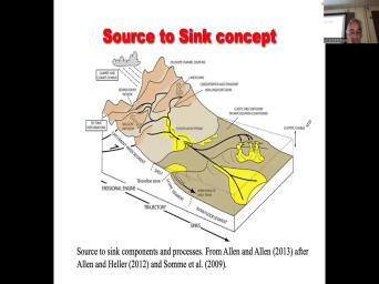
| 10:32 | about the source to sink concept. . And you know, the idea |
|
| 10:36 | simplicity is that, you know, in the patrolling business, we looked |
|
| 10:41 | , we looked at the deposition all . Okay. And just trying to |
|
| 10:47 | a little sit back. I've made few mistakes in my life. You |
|
| 10:52 | , one was was and I say , stuff that I had to |
|
| 10:57 | That's kind of funny because when I younger, I didn't understand how I |
|
| 11:01 | be wrong as a scientist. I so pleased with my work. And |
|
| 11:06 | was only really when I wrote that paper on distributor channels that I |
|
| 11:11 | oh, shoot All those tributary channels my 1992 paper are incised Valleys. |
|
| 11:18 | don't actually really know what a distributor looks like looks like. And I'm |
|
| 11:21 | to be a world expert on Like I read the damn, I |
|
| 11:25 | the chapter in the textbook, How I not know what a distributor channel |
|
| 11:29 | like. And so that would put on a 5-10-year uh, research project |
|
| 11:35 | document them in the field and outcrops modern systems and that pay that work |
|
| 11:40 | done very well for me, And now I've got a much better |
|
| 11:43 | of how to find what a distributor looks like and really emphasized the idea |
|
| 11:48 | branching or distributive network systems and some . You can have thousands of terminal |
|
| 11:55 | channels in some way of dominant You might have one channel that gets |
|
| 11:58 | the way to see and the, channel never splits. Right. Then |
|
| 12:05 | noticed that everybody else was making the mistake and I noticed in the fan |
|
| 12:08 | particular this is kind of a maybe bit of a mean story. A |
|
| 12:13 | of mine who was, you we got along well, but he |
|
| 12:19 | shortcuts and he was trained at S. U. Very traditional depth |
|
| 12:25 | , distribute terry channels, you and he was working at mobile and |
|
| 12:30 | was very ancillary to the project working some bigwigs there, Dick Noyola. |
|
| 12:35 | they published this paper in this book the fair and sandstone that I |
|
| 12:39 | I also published it and they stuck necks out and said, distributor channels |
|
| 12:44 | the Faron Are about 30 m That was based on that quite deep |
|
| 12:50 | line channel that I showed you. I said, well wait a |
|
| 12:55 | That would mean that the river is the size of the Mississippi and for |
|
| 12:59 | Faron to have a river is the of Mississippi, you gotta have a |
|
| 13:03 | of a lot of water there, means you got a big drainage |
|
| 13:06 | I said, I don't think, don't think you can even theoretically have |
|
| 13:10 | delta that big and I forget the name now tom Morris and uh tom |
|
| 13:23 | both professors. Both that one was the Utah Geological Survey. The other |
|
| 13:27 | at Brigham Young University and they were together a PG volume on the fair |
|
| 13:31 | sandstone. They knew I worked on . So they asked me if I |
|
| 13:35 | write a poem. I wrote three in that volume. I wrote one |
|
| 13:38 | Growth Bolts. And then I wrote paper on called searching for modern |
|
| 13:45 | And I was like, what is right modern landlord? I mean, |
|
| 13:49 | know, what is the right what modern delta matches the Faron. |
|
| 13:53 | know, we can use modern analog apply the ancient but vice versa. |
|
| 13:57 | you know, it's an important question , you know, in reservoir characterization |
|
| 14:01 | particular, I already gave you an where we have one model for the |
|
| 14:05 | and valleys and we said, wait minute. That doesn't really imagine the |
|
| 14:08 | analog, Let's look at the modern zai the gulf coast of the Canterbury |
|
| 14:13 | . And let's basically force this ancient to look more like a real modern |
|
| 14:17 | as opposed to something that isn't very . Does that make sense to |
|
| 14:21 | So, and you may not like idea of forcing an interpretation based on |
|
| 14:27 | model. But when you got sparse , you have nothing in between. |
|
| 14:32 | have to use some sort of conceptual to say what what makes sense. |
|
| 14:35 | know, and you're already forcing a , you're you're thinking carefully about quantities |
|
| 14:39 | analog and scales, right? And critical. And so, you |
|
| 14:44 | the mobile guys did this work on ferry and it was a bit of |
|
| 14:47 | Kind of like what I called everything without a lot of stuff in |
|
| 14:50 | But they stuck their necks out and they think that the fairness to reach |
|
| 14:53 | child's a 30 m deep. I , I just, I don't think |
|
| 14:56 | even close to that. I think probably less than 10 m deep. |
|
| 15:00 | uh, and so I wrote this and commentary Bowtie and both did his |
|
| 15:06 | on the modern Mississippi and he was unless you are very savvy about modern |
|
| 15:11 | , but quite a good geologist nature . And we were good colleagues. |
|
| 15:15 | so we wrote a book, we a paper on searching for modern analog |
|
| 15:20 | the fair and sandstone. And at end of that paper, we we |
|
| 15:24 | plugged the Prudhoe Bay field and we used the fair as an analog for |
|
| 15:28 | Bay. But once again, I like, Is that is that the |
|
| 15:31 | ancient analog? Right? You the size of the skin and scales |
|
| 15:34 | systems and the complexity of the fair appropriate for this Perma Triassic massive 24 |
|
| 15:41 | barrel field in Alaska, you is the fare on the right analog |
|
| 15:45 | you know, there's so few well outcrops that you just, you don't |
|
| 15:48 | this huge variety of choice of Um, and so that when the |
|
| 15:54 | Science Foundation introduces source to sink I was kind of like, |
|
| 15:59 | I've been thinking, I'm just thinking scales of systems, you know, |
|
| 16:03 | scale of drainage basin, you what's the largest delta submarine fan that |
|
| 16:07 | could produce with a gift with a for a given given catchment area drainage |
|
| 16:13 | . You know, what, what's, what's, what size of |
|
| 16:16 | can you produce if you know And likewise, if you know the |
|
| 16:19 | of the submarine fan, what's the drainage base that could produce that? |
|
| 16:24 | obviously, to answer that question, you need information about the tectonics, |
|
| 16:28 | relief for elevation, the climate, know. But none of those things |
|
| 16:34 | impossible to estimate estimate in almost any system. You know, that we |
|
| 16:38 | have pretty good ideas of how climate changed where continents are, what paleo |
|
| 16:46 | , you know, and you can this. Climate models have almost any |
|
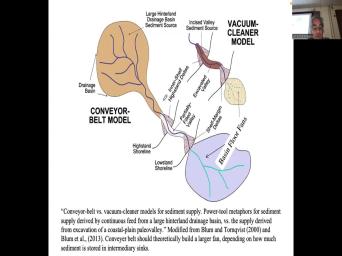
| 16:49 | in Earth's history these days. And we talked about mike blooms idea that |
|
| 16:54 | again, I modified kind of like mike draft this diagram, his submarine |
|
| 16:59 | was exactly the same size in both these diagrams. I said, that's |
|
| 17:03 | . The conveyor belt should have way sediment in the long term than the |
|
| 17:07 | cleaner and the submarine fan should be . Right? And they've got they've |
|
| 17:12 | sandy fans all along the coast of , you know in there. I |
|
| 17:20 | they're not much bigger than Houston. ? Maybe a little smaller. |
|
| 17:25 | The bengal fan covers an area that's like the size of texas. |
|
| 17:29 | So, I mean continental rivers like Ganges brahmaputra make massive submarine fans and |
|
| 17:36 | rivers like the browser's delta make small . Right Now we can argue whether |
|
| 17:40 | said, you know, maybe the fans are richer in sand so they |
|
| 17:44 | be productive. Maybe the bigger fans money because you know, 95% of |
|
| 17:48 | the sediment carried by the Mississippi is , 95% of all the sediment in |
|
| 17:53 | Mississippi fans mobbed. So if you're for sand In, in a submarine |
|
| 17:58 | , that's 95% mud, you better where the heck that sand is. |
|
| 18:02 | . So, and you better know big those sands are and how much |
|
| 18:05 | it is there. That's what it comes down to estimating volumetrics and this |
|
| 18:09 | where the source to sink can Okay, so the sources sink was |
|
| 18:13 | of an NSF funded project, but was quickly grappled on by, you |
|
| 18:20 | , the petroleum community. Now what was ah and you know, we |
|
| 18:28 | of got time here. So I'm to be a bit storytelling to give |
|
| 18:31 | some context when I worked for. , resources Calgary on the offshore east |
|
| 18:38 | Newfoundland? S So made it very , they said we purchased land On |
|
| 18:43 | offshore Atlantic coast that was in less 20 m of water because there was |
|
| 18:48 | way to drill in deep water in days. And you guys may not |
|
| 18:52 | this. But do you know how drilled wells in 2030, 40 m |
|
| 18:55 | water Back in their 70s? they would build a case on an |
|
| 19:03 | island. Yeah. So they build island and stick the rig on |
|
| 19:07 | right. And then they developed Submersible that they could actually put the place |
|
| 19:12 | rigs on the sea floor, With these big hydraulic lifts. And |
|
| 19:16 | finally they with, you know, improvements in computer program with, with |
|
| 19:21 | improvements in G. I. Which allows instantaneous positioning. They will |
|
| 19:25 | have rigs that could float and you just keep them in place. Do |
|
| 19:30 | know how difficult it is to drill hole in five km of water you |
|
| 19:34 | , a three ft hole, not that rig move. And these days |
|
| 19:39 | got cables and stuff, you on a stormy sea with hurricanes and |
|
| 19:43 | and God knows what. Right. , so it's interesting that, you |
|
| 19:47 | , by the time I was at When I quit Arca the second time |
|
| 19:53 | 1998 and went to uh ut There was an explosion of ability to |
|
| 20:02 | in deep water. And that opened the extra deep water plays just totally |
|
| 20:06 | up super capital expensive. You we're talking half a billion dollars almost |
|
| 20:12 | a while. And I mean everybody's working deep water. In fact, |
|
| 20:17 | we had the conversation about our co my position at Ut Dallas, it |
|
| 20:23 | bob black. So well maybe you get in the deeper. I |
|
| 20:25 | yeah, I could really river delta . That's what I know best. |
|
| 20:30 | I don't know, there's, there's lot of good people doing deep water |
|
| 20:33 | . I really want to compete that lots of oil and gas and Deltek |
|
| 20:37 | while all everyone's racing towards deepwater, ignoring shallow water and I'm going to |
|
| 20:43 | gains there. And so I think gonna happen, I'm gonna keep plugging |
|
| 20:46 | at that. And suddenly people could we should have got these Oldfields |
|
| 20:51 | exactly what you said, who needs ? Just put the wells in. |
|
| 20:55 | , the problem, if you don't to jobs for too long, you |
|
| 20:58 | getting to declining rates. Suddenly yeah. You know, as the |
|
| 21:02 | matures, you need more geology, ? The, the common history of |
|
| 21:07 | oil field, you find it, up Virgin pressure. You start pulling |
|
| 21:12 | oil out and 10 to 20 years , all of a sudden things are |
|
| 21:16 | , you realize, oh, the layer cake model just doesn't work |
|
| 21:20 | Now. Now, now drilling is expensive. We're targeting horizontal wells, |
|
| 21:25 | know, in filling wells, water and our simple models that worked at |
|
| 21:30 | pressure when we just pulled the oil . Now having to do secondary tertiary |
|
| 21:36 | , those models are inadequate, we better, we need more, more |
|
| 21:39 | geology, Jonah Bhattacharya to the Let's put some plant forms in. |
|
| 21:46 | anyway, so the deepwater play was bit different because it's so expensive, |
|
| 21:52 | expensive to explore. The capital costs very high, Right? And so |
|
| 21:58 | an interesting dilemma with deep water, find a prospect, and you |
|
| 22:02 | well, we think that there's When was in argued that the smallest offshore |
|
| 22:06 | , we could drill was about half billion barrels, maybe 400 million, |
|
| 22:10 | think small, that that's a lot oil, right, but anything |
|
| 22:13 | that was just too, it just worth it. Right, too |
|
| 22:17 | Now, that was one of the of all, was $11, |
|
| 22:20 | When I went to under $40 a , you could go for smaller |
|
| 22:24 | um there is a dilemma, you , you're, you're the drilling engineer |
|
| 22:31 | you're the facilities engineer, you've got prospect to say, well, we |
|
| 22:34 | it's probably a billion barrels of recoverable , Okay, how many wells do |
|
| 22:39 | need to get that out? Maybe You know, 10 s wells, |
|
| 22:43 | know, What's the recovery factor could helped, you know, probably get |
|
| 22:47 | of the oil out and that's what plan for and then you find out |
|
| 22:52 | it's actually a four billion barrel Oh shoo you've undercapitalized the asset. |
|
| 22:58 | , let's say you think it's four barrels and there's only half a billion |
|
| 23:02 | economic, but you've way overbuilt the , right? And and in traditional |
|
| 23:09 | fields you drill a well found the , then you do a step |
|
| 23:11 | you know, and you kind of the infrastructure as it goes in deep |
|
| 23:15 | . The other thing is uh do understand cycle times present values, |
|
| 23:21 | So, okay, so if I a dollar today And the payouts not |
|
| 23:26 | 10 years in 10 years, that is only worth Maybe 20 cents, |
|
| 23:31 | ? I invest a dollar today and get the money back in two |
|
| 23:35 | The present value, that dollar is lot more, right? Just imagine |
|
| 23:39 | you discover. Prudhoe Bay Field in . And the first of all comes |
|
| 23:45 | in 1977, you spent maybe $10 to put the pipeline in to |
|
| 23:52 | to just get the, to get , to build the roads to get |
|
| 23:56 | to Prudhoe Bay, then you got build a pipeline from the north slope |
|
| 23:59 | Valdez across all of Alaska, how money that costs and you don't know |
|
| 24:05 | going to happen to price for in nine years, Maybe it's going to |
|
| 24:08 | for $40-$5, right? I we talk about risk at any |
|
| 24:14 | So companies realized the short of the time, the more money they can |
|
| 24:17 | a deep water has a shorter cycle because it's all offshore. Right? |
|
| 24:21 | build a platform, you stick it and it doesn't, you know, |
|
| 24:24 | it all floats and it doesn't take long to rent a platform or by |
|
| 24:30 | as it does to build a pipeline half a continent. Right? So |
|
| 24:35 | are trying to reduce the cycle That means they need they needed to |
|
| 24:39 | need to understand the capital costs Earlier that meant they needed much more |
|
| 24:44 | knowledge about the size and scale those reservoirs to make a long story |
|
| 24:49 | all the oil companies got together and said, you know, we're gonna |
|
| 24:54 | all these academics, which means they want to publish. So there was |
|
| 24:58 | an enormous amount of of integration in huge community on deep water. And |
|
| 25:04 | really did a remarkable job of of kind of moving our knowledge of |
|
| 25:09 | waters faces models and sequence took me . All right. So step one |
|
| 25:16 | , you know, what are the , the deepwater system. A lot |
|
| 25:19 | them are on this slide here. got the submarine fan, we've got |
|
| 25:24 | submarine canyon, we've got the staging , which is the continental shelf and |
|
| 25:29 | . We've got a river, a , a catchment area. We've got |
|
| 25:34 | of the mountains that that that are are that are capturing the water and |
|
| 25:38 | the sediment. We've got the length the shelf, we've got the size |
|
| 25:41 | the slope. We've got the width and depth of submarine canyons. |
|
| 25:46 | got the size scale length, depth of the submarine fans. And so |
|
| 25:54 | what what the normally what status or now Ecuador? I think this |
|
| 25:59 | I think the status of work and others got in the game, they |
|
| 26:02 | , we're just going to collect information all these parameters shelf which shelf, |
|
| 26:07 | , slope, length, shelf, , water discharge, county and distance |
|
| 26:11 | . The length of the river channel of the mountains, size and scale |
|
| 26:15 | canyons and fans. And just see there's any relationships, right. Some |
|
| 26:21 | the things you can measure, maybe can measure the size of the submarine |
|
| 26:25 | . Maybe you already know what the of the continental shelf is. You |
|
| 26:28 | , depending on, you know, typically, you know, let's think |
|
| 26:31 | the Gulf of Mexico in the Gulf Mexico enormous amount of data on the |
|
| 26:35 | shelf that's been producing since the Right? The question is, |
|
| 26:39 | now we're moving to off the deep , which is much more extensive. |
|
| 26:43 | we take this massive database of onshore and project where the big submarine sandy |
|
| 26:48 | are going to be. Are we draw sandy fans or muddy slump |
|
| 26:53 | right? You can lose a lot money if you're doing the wrong |
|
| 26:56 | And then a lot of those things stuff sold. That's a whole another |
|
| 26:59 | thing thing. So there was a of incentive to solve as much as |
|
| 27:04 | to predict the size and scale of elements of deep water systems. There's |
|
| 27:09 | unconventional about deep water. You're looking a conventional sand with conventional ferocity. |
|
| 27:15 | only thing that's problematic is it's freaking . Okay. And because it's, |
|
| 27:21 | so expensive, you can't put an number of wells down there. |
|
| 27:26 | That's, that's why there's a limitation the volumes, because you can only |
|
| 27:30 | put, You know, you can't 10,000 wells down in deep water field |
|
| 27:34 | a half billion dollars. You price out of out of existence. |
|
| 27:39 | And maybe you can put horizontal but you can, because you can |
|
| 27:41 | put a few wells, you need of volumes from those few wells, |
|
| 27:44 | ? So it's the opposite of shales you can put as many walls as |
|
| 27:48 | want to write drill towers off. , the payoffs a couple of |
|
| 27:52 | very short cycle time, repeat your value comes very soon after the |
|
| 27:58 | Then you drill another well, the of oil drops, you stopped |
|
| 28:01 | President goes back. If you just doing it right. You know, |
|
| 28:04 | it's a very immediate business, not for deep water that it's, |
|
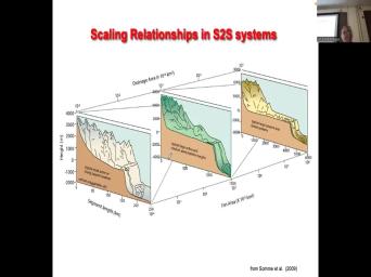
| 28:08 | it's longer term. So now. they started sort of sort source distinct |
|
| 28:16 | . So on the front of the , we've got, Uh, m |
|
| 28:23 | relief, We've got a couple of 250 m of distance from proximal to |
|
| 28:29 | . Okay, so this is a system, right? This this could |
|
| 28:33 | where, you know, there's plenty places where you've got, you |
|
| 28:36 | a mountain chain like California, and the ocean is lapping up against the |
|
| 28:40 | , right? So the mountains may high, but there's a small source |
|
| 28:43 | sink systems. It doesn't take much go from the mountain to the deep |
|
| 28:48 | . Okay, then on the other , you've got systems that are 9000 |
|
| 28:53 | high. So that could be the Mountains, but but the the sand |
|
| 28:57 | to get from the Rocky Mountains all the prairies into the gulf coast. |
|
| 29:01 | a continental scale system. So now got 6000 kilometers on the horizontal |
|
| 29:07 | whereas in the, in the front , we've got 250 m Right? |
|
| 29:12 | then in the intermediate, you've got m of relief and we've got 1500 |
|
| 29:17 | of distance, right? And then got fan area times 10 to the |
|
| 29:23 | , going from small fans that are to the modest, too square kilometers |
|
| 29:29 | area all the way up to, , 10,000 times 10 to the |
|
| 29:36 | So so that would be 10 to 7th. So that's a 20 million |
|
| 29:43 | kilometers, 20 million square kilometers? a big fan. Right. You |
|
| 29:50 | , that's, that's a couple of . Ah, I mean, some |
|
| 29:54 | these fans get up to 1000 km 1000 km. Right? So that's |
|
| 29:58 | million to 56 million square kilometer And when you got that kind of |
|
| 30:04 | estate, there's no aircraft in the that's going to give you 1000 km |
|
| 30:08 | continuous exposure. Right. So a of our knowledge of big submarine fans |
|
| 30:12 | almost solely derived from seismic data. are however, smaller fans, |
|
| 30:17 | Some of those smaller fans are uplifted , have you ever heard of the |
|
| 30:20 | Fork sandstone in and in Arkansas, a relatively small submarine fan that's nicely |
|
| 30:28 | in the outcrops around little while. you. So let's look at their |
|
| 30:34 | . So there's a gazillion diagrams, , but they're pretty straightforward. |
|
| 30:39 | I mean, it's not, you , it's not necessarily difficult to |
|
| 30:43 | And these are just a selection of of the things they put in |
|
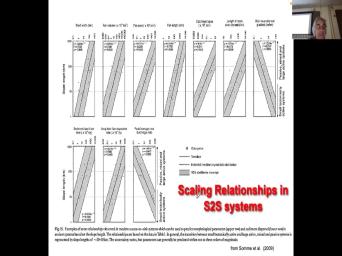
| 30:47 | So here we've got slope length on vertical axis. So that's uh, |
|
| 30:54 | is, that's that distance there. the big, biggest slope, the |
|
| 31:00 | the system, small slopes smaller system then they've got a shelf width, |
|
| 31:07 | , volume, fan area, fan , catchment area length of the main |
|
| 31:12 | channel? Main river channel gradients. , so what parameter you interested |
|
| 31:18 | Mcdonald's, you pin pretty spot on we talked about gradients. So, |
|
| 31:23 | this shows is that the, the, the flat ist channels correlate |
|
| 31:32 | the wider shelves, the largest submarine , the largest submarine fan areas, |
|
| 31:38 | longest fans and the biggest catchments. . So the bigger the system to |
|
| 31:43 | the slope pretty straightforward, but that's useful information. Right. If |
|
| 31:48 | know something about the slope of the , you could go on this diagram |
|
| 31:52 | say that the volume of the fan be this big. Now you've gone |
|
| 31:55 | a slope estimate directly to a volume . Okay, now that's inviting with |
|
| 32:00 | fan, how much sand is in ? Well, if there's only 5% |
|
| 32:03 | , you take the volume of fan it by 5%,, then you got |
|
| 32:08 | ball in the sand multiply that by process and you've got yourself a potential |
|
| 32:13 | process, Is that 20 billion barrels million barrels before you've done any |
|
| 32:18 | I can say that's just, that's enough to even worry about. Don't |
|
| 32:21 | bother exploring in that area. Or could say, my goodness, that |
|
| 32:24 | be a trillion dollar prize, let's going. Right, That's how you |
|
| 32:28 | these diagrams. Right, Let's look something else, right. You |
|
| 32:32 | something about the catchment area. So in the middle of the cretaceous, |
|
| 32:35 | seaweed is very wide, you you've got small, small catchments. |
|
| 32:39 | you're kind of down here, you , well, the biggest fan you |
|
| 32:43 | get, could be here 10 to here. So that's ah one cubic |
|
| 32:53 | . Okay, A cubic kilometer is to 30 times seven thirds september 3rd |
|
| 33:01 | meters. So that's a billion cubic of sound at 20% ferocity, that |
|
| 33:07 | be 100 million, 100 million cubic of oil. Oh, sorry, |
|
| 33:15 | cubic News of the World, which 600,000 barrels. Okay, something like |
|
| 33:19 | . Right? Trying to use my , you know, and you, |
|
| 33:22 | you might go like, well, offshore, no way. But if |
|
| 33:28 | in the middle of a, you , if that's the submarine fans in |
|
| 33:31 | pr shale, which is a big , you say? Yeah, |
|
| 33:33 | that's worth drilling, you know, wells three kilometers down and we can |
|
| 33:37 | ourselves pretty good. Well, do you see how you go |
|
| 33:41 | from one parameter, you might have that estimates something that you need to |
|
| 33:46 | , right? We always need to volumes. Okay. And volumes, |
|
| 33:50 | course, the function of the area the length and so on. |
|
| 33:55 | you know, and, and these things that, you know, you |
|
| 33:57 | have information on these because you've got lot of information on the, on |
|
| 34:02 | here, we've got slope, continuing slope length vs sediment load or |
|
| 34:07 | of the river, uh fan de rates and peak versus average river discharge |
|
| 34:16 | , right? So, you and they've got to remember, we |
|
| 34:21 | about probability distributions and So this is 90% confidence interval. So typically what |
|
| 34:29 | means is that there's, you a 95% chance that they're bigger than |
|
| 34:33 | low case and there's a, there's 5% There's only a 5% chance that |
|
| 34:39 | bigger than the high case. It's way you use these diagrams. |
|
| 34:42 | So, again, what that means , you know, let's say that |
|
| 34:45 | you've got some play when you tell , well, I think the submarine |
|
| 34:49 | is, is got this volume of sediments in it right up |
|
| 34:55 | you know, for a river channel that's um, or a gradient that's |
|
| 35:01 | like that might say, well, know, your estimate the fan dwelling |
|
| 35:05 | on the upside of the upside of upside. So you're being a little |
|
| 35:08 | aggressive in your estimate, maybe you my dollar back or maybe that's the |
|
| 35:13 | 95 you want to go with the 50 Right? You know, and |
|
| 35:17 | he said, Well, can we money at p 50? You might |
|
| 35:19 | , well, a p 50 volume even p 95 we're billionaires and |
|
| 35:25 | you know, five, which means a, there's a 95% is big |
|
| 35:29 | that, you might say we lose at the P five, but we |
|
| 35:32 | tons of money at P 50 and filthy rich and P 95 or you |
|
| 35:37 | find that you make money P five then you're like, okay, this |
|
| 35:40 | the lowest place you go, go, go for it, |
|
| 35:46 | okay. And of course, you , sequence photography, it does many |
|
| 35:54 | , but what it does is force to correlate surfaces through as much of |
|
| 35:59 | basin as possible so they can correlate river systems to the delta is the |
|
| 36:03 | water. Right? And what this emphasizes when sea level is low and |
|
| 36:09 | systems get to the shelf edge. when you get the submarine fans, |
|
| 36:14 | sea levels high and the shorelines are to the inner shelf, that the |
|
| 36:20 | basin is basically condensed section. That's bad, because that means that's when |
|
| 36:24 | getting your source rock and new seals deposited and the slug and the sequence |
|
| 36:29 | strata. Graphic block diagrams emphasis when got low sediments that low stand out |
|
| 36:35 | the basin versus the distal basin is covered by shales or condemned section. |
|
| 36:43 | is work done by steve good bread his graduate advisors steve keel ah and |
|
| 36:49 | show that in the in the Ganges Bengal fan at low stands, you |
|
| 36:55 | these low stand deltas, but high . Again, there's a lot of |
|
| 37:00 | going on here, you can store 50 at times you store 50% of |
|
| 37:04 | basis of the non marin and there's nothing much getting out into deep |
|
| 37:08 | So, you know, the submarine aren't always active. And the bigger |
|
| 37:12 | system, the less, the less that sediments delivered at high stands. |
|
| 37:19 | is work done by christian Carvajal and supervisor Ron steal it. Ut |
|
| 37:26 | And this is the couple of nice to illustrate here. Ah this is |
|
| 37:37 | , there's a nice shoes. Um another shot sam and there's the searches |
|
| 37:57 | and what's in need is uh, going to make a mistake here, |
|
| 38:05 | don't worry about it too much. uh there's the louis shale, louis |
|
| 38:15 | , then there's the lance formation and Fox hills. Fox hills, I |
|
| 38:26 | have a lance in the Fox hills , but it doesn't matter. And |
|
| 38:30 | there's the sand stones down here and think, I don't remember that they're |
|
| 38:35 | a separate little formation name. I they're just considered a member, of |
|
| 38:39 | , of the Lewis shale. I I got that roughly. Right, |
|
| 38:44 | . And of course this is the lytham strategic graffiti of the, of |
|
| 38:51 | , of this campaign in basin, Wyoming what kind of the name of |
|
| 38:57 | basin? It's a terrible oh alluvial channels and that, so I |
|
| 39:02 | it, I got it incorrect, the lances, the flu viel, |
|
| 39:06 | fox hills is the marine and then the louis below. Anyway, it |
|
| 39:12 | matter too much. So, but the little strata. Graphic units have |
|
| 39:18 | to do with the conifers. this is another lovely example where the |
|
| 39:22 | forms connect up different with a strata defined formation right in the old |
|
| 39:28 | when you when you don't have any , logs, you know, you're |
|
| 39:31 | broadly showing where the different faces But of course, sequence figures. |
|
| 39:35 | , that's not that's not, that help us define the reservoir ceo |
|
| 39:39 | So this is another good example where sequence photography completely gives a different picture |
|
| 39:44 | the lithography photography. Okay. And were able to map individual channels in |
|
| 39:49 | lance and connect these up to specific fans. It's a very detailed |
|
| 39:58 | They also had a lot of bios and they're able to do things like |
|
| 40:01 | the sedimentation rates of this source to system. It's also one of |
|
| 40:06 | one of the few times in the western interior seaway, We get platforms |
|
| 40:13 | are almost 1000 ft high. So getting to continental shelf slope, this |
|
| 40:18 | the middle of the cretaceous seaway. it's not actually a continental margin, |
|
| 40:22 | it is a pretty good sized So going back to our deep water |
|
| 40:28 | , you know, we have a of, of elements that we find |
|
| 40:32 | deep water systems. We've got the got these things called mass transport complexes |
|
| 40:39 | includes slumps slides and debris foes. me get these ah we get these |
|
| 40:47 | levy complexes probably heard of these things frontal displays for sandwich. The channel |
|
| 40:55 | complexes tend to be more mud They're both fed by submarine canyons that |
|
| 41:00 | into the slope and of course they're by the systems that are, that |
|
| 41:05 | delivering sediment in the staging area. the river can feed directly the submarine |
|
| 41:12 | . You've got rivers feeding submarine fans sometimes the slope simply fails as a |
|
| 41:18 | slide that can mix with seawater and into attributed current. Or it can |
|
| 41:24 | move down the slope as a slump slide or debris flow. Right? |
|
| 41:29 | there is a relationship between mass transport and turbidity currents in terms of one |
|
| 41:37 | into another. Okay, that's more a sediment ology topic. And Bill |
|
| 41:41 | have covered that in his class in little bit of detail. And then |
|
| 41:47 | got these things called sediment waves that to oceanic currents that move on the |
|
| 41:53 | sea. These things are called contour like the deep western boundary undercurrent that |
|
| 41:58 | to large scale oceanic circulation. And course, in the Shannon levy |
|
| 42:04 | you've got place where the flow can out of the channel producing a crevasse |
|
| 42:10 | , which is another quasi sandy This diagram, it's generic, but |
|
| 42:19 | , it's a little bit California these small California fans and emphasizes |
|
| 42:24 | you know, a fan by definition a Geum or Fick feature. It's |
|
| 42:29 | like a fan. Okay. And course, internally it it's built by |
|
| 42:34 | currents and debris flows and slumps and . Uh and uh you can get |
|
| 42:40 | waves remolding the surface. Uh and can get channels building out over the |
|
| 42:44 | of them. Okay. Sometimes the fan can be fed by sand moving |
|
| 42:51 | the shore face if the canyon extends the way to the, to the |
|
| 42:54 | line, uh that's more common in narrow shelves. The wire, the |
|
| 43:00 | , the less likelihood that that So in California for example, you |
|
| 43:04 | get sedimentation and submarine fans at high . And guys like jake, cobalt |
|
| 43:09 | brian romans go on about. you can get summary fans and high |
|
| 43:13 | like, yeah, in California because have a very narrow shelf, but |
|
| 43:17 | don't get that in the Mississippi, has a continental scale margin. So |
|
| 43:21 | not get too extent too excited about submarine fans. Okay, so here's |
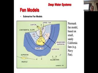
|
| 43:27 | early fan model again based on one these California fans, which was some |
|
| 43:32 | the earliest to be studied because they're . And it was, it |
|
| 43:36 | it was easy for these academic researchers get some seismic and discriminatory data on |
|
| 43:41 | small fans. The bigger fans are expensive to survey. And so it |
|
| 43:46 | a little longer to get good data those larger fans and what they noticed |
|
| 43:51 | in general that the fans have a or low bait shape. Okay. |
|
| 43:56 | they noticed that they have sort of distal area that's low gradient and fairly |
|
| 44:01 | . And then they have these little and they call those things super |
|
| 44:05 | which means a fan or a bump top of a larger fan, a |
|
| 44:09 | fan on top of a larger And those they they they they thought |
|
| 44:14 | relatively sandy elements superimposed on kind of muddy platform. And these things are |
|
| 44:23 | bit like delta lobes fed by channels they can evolve laterally. And of |
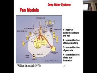
|
| 44:28 | they're fed by submarine channel that that flowing within a submarine canyon. And |
|
| 44:36 | got an upper fan area that steep that commonly has a bunch of slumps |
|
| 44:41 | slides. And that's a 1978 Roger walker was, he was good |
|
| 44:49 | with Bill. No Mark. Bill was really more of a geophysicist. |
|
| 44:55 | fan models were based on geophysical surveys fans. Roger walker was an outcrop |
|
| 45:01 | . I never looked at any seismic in his life that I could ever |
|
| 45:05 | . And so, so he has similar model to Bill Nor Mark, |
|
| 45:09 | now he's added these little vertical So what you might see an outcrop |
|
| 45:13 | Korver submarine fan. So the lower is characterized by thin bedded turbo lights |
|
| 45:18 | mud stones. So thin bedded The super fans are characterized by amalgamated |
|
| 45:25 | stones, massive sand stones. So would be good quality reservoirs. The |
|
| 45:31 | levee that, that the levees along March of the channels walker interpreted as |
|
| 45:36 | muddy embedded and then the channel fills be sharp based finding upward kind of |
|
| 45:42 | river channels but lacking cross bedding because they're they're fed by turbidity currents which |
|
| 45:50 | the formation of the dunes that may bedding and then a variety of slump |
|
| 45:54 | slide deposits kind of in this upper . Now, by the 90s, |
|
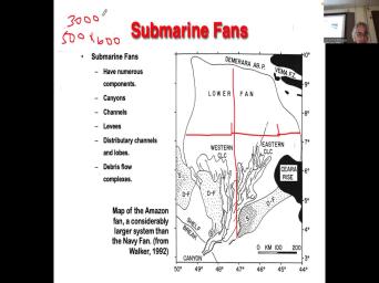
| 46:04 | was a geophysical surveying of some of much bigger fans. Look at the |
|
| 46:09 | , Okay, this is the amazon , look at the scale, that's |
|
| 46:20 | 400 That Sucker is 500 km 200 400 600 By 600 km in |
|
| 46:35 | . Okay, 500 times 600 is plus zero zero 00. Did I |
|
| 46:57 | that right? Is that correct? , yeah. So that's 300,000. |
|
| 47:09 | that by Columbia thickness. You've got a heck of a volume of sediment |
|
| 47:13 | . But it's, you know, , it's mostly mud folks. Right |
|
| 47:18 | this large scale fan consists of this flat lower fan that's fairly muddy. |
|
| 47:24 | you've got these channel levy complexes or Lcs, there's a western complex and |
|
| 47:29 | dory concept. And then you've got mass transport complexes and they comprise slumps |
|
| 47:36 | great seaward into debris flows and they on top of the channel. Every |
|
| 47:42 | . Okay, so you've got and course they're fed by a submarine |
|
| 47:47 | You've got a canyon with channels and their inter inter bedded with slumps |
|
| 47:54 | debris flows or mass transport complexes. ? So that, so those are |
|
| 47:59 | basic architectural elements that build these And what's interesting is if you look |
|
| 48:07 | , the guy's hand wasn't shaky these meander. Nobody was expecting this in |
|
| 48:13 | 90s when these uh, geophysical surveys these modern fans came and as I |
|
| 48:19 | that the volumes are pretty astounding. the Amazon width is 252, 7 |
|
| 48:27 | volumes are, let me see 70,000 of sediment, um, One million |
|
| 48:38 | of sediment in the India's and so and so forth. So big, |
|
| 48:42 | , big big systems. Now we the clock forward 2006. Now we're |
|
| 48:48 | the realm of three d. And one of the things that Henry |
|
| 48:53 | material realizes that when you got three . Seismic, the first return is |
|
| 48:56 | sea floor. If you're shooting seismic on over modern submarine fans, you're |
|
| 49:02 | . You get great image of of the bathroom metric features that are |
|
| 49:09 | the submarine fans. So here's the there. Okay, here you've got |
|
| 49:16 | nice debris flow. There's actually levies the debris flow and then you can |
|
| 49:20 | this, this big zone of, looks like the scale here is |
|
| 49:27 | it isn't gonna scale. But you these, I think the thing is |
|
| 49:31 | A couple of 3, 4 km this, this this channel width |
|
| 49:39 | So there's some to do more for . He's got a a submarine meandering |
|
| 49:45 | that used to be here. It . Its position involves now it's over |
|
| 49:51 | and I'll show you some other images of this later. And then you've |
|
| 49:54 | these debris flow lobes, whole bunch those more debris flows here. And |
|
| 50:02 | you've got this debris flow channel and the debris flow lobe that comes out |
|
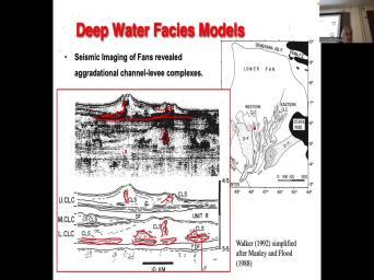
| 50:07 | the mouth of it. So you've these architectural elements uh, that build |
|
| 50:15 | submarine fans. Okay, so let's back to this diagram here and |
|
| 50:23 | We've got a little cross section. ? So that little red bar there |
|
| 50:30 | across that channel levy complex. And the, on the above is the |
|
| 50:34 | Image. Now, this is old eighties nineties two different surveys. And |
|
| 50:41 | things to me look like little Of course they're not because there's photography |
|
| 50:47 | them, but there's no magma These are not volcanoes. These are |
|
| 50:52 | levy complexes, The high amplitude reflections horrors they used to be called, |
|
| 50:58 | sandwich. So these are Sandra rich . So we can sort of image |
|
| 51:04 | high energy sand. Okay, uh sort of transparent stuff that lacks |
|
| 51:13 | So there's no lines in here, debris flows, It's so chaotic that |
|
| 51:17 | there's no layers to produce a reflection they're muddy. So they have low |
|
| 51:22 | . So this is not much return them, right. The sound waves |
|
| 51:25 | go through it and you can see now that you have a channel that |
|
| 51:28 | laterally and then lift it up and one migrated laterally, lifted up. |
|
| 51:33 | . And you've got evidence of high reflections here in this older channel levee |
|
| 51:40 | on the lower diagram. They've kind given the the interpretation of the |
|
| 51:44 | there's this channel levee system okay, levies on the outside and the channel |
|
| 51:49 | the middle of it, of And that's the sweet spot. |
|
| 51:53 | that's the sweet spot. The debris are not so much interest. And |
|
| 52:00 | also some sand down here. That's interest. Right? And so you |
|
| 52:06 | this sort of sheet of sand, base of these systems that over lies |
|
| 52:11 | debris flow and it's over land by channel levee system. And that seems |
|
| 52:17 | be a pretty consistent relationship, a flow, then you get a sandy |
|
| 52:23 | fan, and then you get a your channel levy complex. Right? |
|
| 52:27 | we get the stacking of fans strata . And in 1992 we didn't really |
|
| 52:35 | why we see the systematic systematic But in 2006 post Material Walker |
|
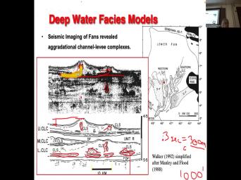
| 52:41 | we think we understand why you see systematic stack. Now there's another piece |
|
| 52:48 | information I would like to highlight and that's the vertical scale. |
|
| 52:55 | on the side here, we've got two way travel time? So the |
|
| 52:59 | floor is around 4.7 seconds. Two travel time of 1500 m. So |
|
| 53:07 | would be 4.7 seconds of two way time would be about 2 - three |
|
| 53:17 | deep. 2.35. Right, so submarine fans are down and 2300 m |
|
| 53:26 | water. And now check out the here. So there's the top of |
|
| 53:32 | of the channel and there's the base the channel. Right. So what's |
|
| 53:37 | distance from the top of the channel the to the to the if you |
|
| 53:42 | like that, it's not a but the area adjacent to the |
|
| 53:47 | How much? Two way travel time that? Okay. Okay. So |
|
| 54:08 | that tweet that equals What thickness? that? Okay. How many feet |
|
| 54:44 | that? 300 Much. Smarter by . Daddy Multiplied by 3.3. Can |
|
| 55:10 | just report it? I don't know this device is breaking from them. |
|
| 55:13 | just we're just converting meters to That's all three computers Is about 1000 |
|
| 55:20 | . Mm hmm. 1000 ft. . Have you ever been to New |
|
| 55:26 | ? Okay, Angela, you ever New Orleans? And Okay. You're |
|
| 55:31 | standing on the banks of the Mississippi . How far, how far down |
|
| 55:35 | the floodplain? The floodplain is lower the levee. Right, but what's |
|
| 55:39 | relief of the biggest river in north , Is it 1000 ft. Is |
|
| 55:53 | 100 ft? Not even close, might be about 10 or 20 |
|
| 56:00 | Right, So this is two orders management relief between the channel and the |
|
| 56:05 | adjacent to it. So, although some analogs to these deepwater meandering |
|
| 56:12 | boy, oh, boy, there far from the Mississippi of modern |
|
| 56:16 | as you can imagine. Right. , very different. Okay, |
|
| 56:22 | look on that note, I think take a little break. Right? |
|
| 56:28 | a quarter to, so I'll break . This is work from Jim Collins |
|
| 56:47 | Arnold Obama on the Mississippi fans has worked on by paul Weimer at University |
|
| 56:53 | Colorado. And then the Mississippi Mississippi , another big system noticed 100 km |
|
| 57:01 | . Right, so it's 100, 300 400 500 600 big system. |
|
| 57:13 | . And there's a series of cross from proximal eh, to digitally and |
|
| 57:18 | in approximately area, you see a incised canyon that continues to be |
|
| 57:25 | And as you go down, you to see channels, levies debris |
|
| 57:31 | uh, and they get more and flatter and more laterally spread out as |
|
| 57:35 | go down. Found. You'll also that you've got the sort of debris |
|
| 57:43 | and then a higher energy faces. the channels, you commonly see these |
|
| 57:47 | flows? Kind of underlying the channel complexes? We're gonna finish off by |
|
| 57:53 | about the order in which these elements as a function of the sequence |
|
| 57:58 | graphic position. So here's some seismic from Henry's work. So in the |
|
| 58:09 | section you see that there's a series immigrant thrust sheets, so that would |
|
| 58:15 | a classic slump. Okay, slump into a slide and in plan view |
|
| 58:22 | can see a series of pressure Right, And that's part of those |
|
| 58:28 | terminating up against the top of of the, of the slump slash |
|
| 58:33 | . Okay, one of things I about Henry is always looking for modern |
|
| 58:38 | . So he was living in Calgary snow and noticed that the little |
|
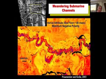
| 58:42 | you haven't seen snow, have Well, you have seen snow. |
|
| 58:46 | , Is that okay? Did you a shovel it? Okay. It's |
|
| 58:57 | , we have more than enough snow shovel in Canada. If you ever |
|
| 59:00 | to come and try your hand at , I'm sure you'll be very |
|
| 59:04 | And so, you know, here , here is a, a series |
|
| 59:08 | thrust faults formed during the snow and of course are analogous to the thrust |
|
| 59:13 | you see in a slump. The physics is pretty similar. Here's an |
|
| 59:18 | of a nice submarine channel and the thing about these things is that they |
|
| 59:24 | , that means that they can be sinuous. They tend not to migrate |
|
| 59:28 | as laterally as rivers. And that's lot of pretty currents kind of partly |
|
| 59:36 | . So they have a lot of to lift off the floor. There |
|
| 59:42 | some older meander loops and some slumps . Mhm. So here's a cross |
|
| 59:53 | on the top. You got a . So there's the channel meandering channel |
|
| 59:58 | its way through and that's the cross across the channel and there is the |
|
| 60:06 | you can see it's got lateral accretion it. There is to base the |
|
| 60:11 | migrating. So that's the line interpretation the right, so the channel Phil |
|
| 60:18 | course is where the is almost all sound? The passive channel film might |
|
| 60:24 | muddier and the levees are a fairly bedded. Okay. Um and there |
|
| 60:41 | the same system with no vertical Okay, now I want to do |
|
| 60:57 | reserves calculations. Okay, so that basically sand that I've colored in |
|
| 61:28 | Okay. Question one. How thick the sand? Doesn't matter meters, |
|
| 61:37 | easier. Okay. Okay so and how wide is it? There's a |
|
| 62:06 | km scale at the bottom, There's a 10 km scale there look |
|
| 62:24 | So how wide is the sound? , no the sand? Okay, |
|
| 62:37 | we can break this into two We could have a wide part that's |
|
| 62:40 | let's say it's 10 km wide And m thick. Okay, so what's |
|
| 62:47 | area? So 100 m by 10,000 . Okay and let's assume that that |
|
| 63:17 | is continuous for a couple of kilometers and out of the page. |
|
| 63:25 | So another 200,000 m Now you've got volume. What's the volume also? |
|
| 63:48 | , walking up Mhm. Okay, you've got 220 billion cubic meters of |
|
| 64:11 | . Okay, Convert that to assume 20% 25% ferocity. So multiply that |
|
| 64:18 | .25, I'll make patrolling geologists you yet. So that's a 55 billion |
|
| 64:37 | of possible fluid m3. How many is that? We've got to convert |
|
| 64:45 | meters. Two barrels, It's about or six just multiplied, multiplied by |
|
| 64:54 | . Make it easy 55 times five sure would you like to have that |
|
| 65:08 | ? Right. So that that's the water play. Right. You |
|
| 65:12 | these channels can have billions of barrels ferocity, Right. Depending on how |
|
| 65:18 | of it is is water versus oil ? That kind of gives you a |
|
| 65:22 | for the volumes. Right. And you know, and it's |
|
| 65:27 | it's really good for you as petroleum to be able to kind of do |
|
| 65:33 | calculations fairly quickly. Like what you'll when you, when you start presenting |
|
| 65:38 | really good managers, they've got a for these numbers and they will quickly |
|
| 65:42 | out what the prizes and whether your are wacky or not. Right. |
|
| 65:46 | it's good to kind of and I to work in meters because it's always |
|
| 65:49 | to convert cubic meters. I forget the conversion is. It's about five |
|
| 65:53 | six, you know, multiple, five or six. And then you |
|
| 65:56 | yourself a barrel. You multiply that the price of oil and you've got |
|
| 65:59 | your prize. Right, So where we how many barrels of oil barrels |
|
| 66:03 | potential oil to? So cra And multiply that by $100 a barrel. |
|
| 66:09 | the prize in terms of dollar Let's do it. Let's get the |
|
| 66:16 | look for us. Yes, so probably $2.7 trillion. That's a $3 |
|
| 66:35 | dollar prize. That's crazy. Here's that people don't understand. People have |
|
| 66:44 | idea about the value of your right? You know. Anyway, |
|
| 66:52 | back to this slide. Okay, for going back so long. I |
|
| 66:58 | gonna do the calculation with this, the vertical scale is I can't see |
|
| 67:02 | . It's it's a there's a 50 millisecond vertical bar but it's because i |
|
| 67:07 | just slipped off the slide. But , you know, it points out |
|
| 67:11 | these sands look at the scale on bottom line, the bottom diagram is |
|
| 67:15 | vertically exaggerated. So that sound is 10 km wide and it looks like |
|
| 67:21 | about again, maybe 100 200 m , 200 m of pay. |
|
| 67:28 | that's a lot of pay, So I just wanna emphasize the scale |
|
| 67:31 | these systems, right? It's amazing isn't even better image of a levee |
|
| 67:36 | is from the gulf of Mexico. they can see the the shelf, |
|
| 67:41 | is the salt Mini Basin province. then we've got these three D. |
|
| 67:46 | that are highlighted there are highlighted and with the gray color. And here |
|
| 67:57 | can see a beautiful, beautiful sinuous belt. There was this levy and |
|
| 68:07 | it drops off ultimately into the base the floor. Right? Always got |
|
| 68:12 | the slope is .07. So let see here, .07 and that would |
|
| 68:35 | about four degrees. No, is right? No, I think that |
|
| 68:46 | the slope on the slope on the towel wave slope, .07 Brown |
|
| 68:54 | focus .32 John you will see is trying to convert those. I'm not |
|
| 69:00 | if those are in degrees or absolute . Anyway. Now, of course |
|
| 69:04 | can look at systems in our crop you get kind of a, just |
|
| 69:09 | of what I'm doing is just giving and this is a bit more |
|
| 69:12 | But just giving you an idea of well, you know, there's |
|
| 69:14 | yes, there's this meandering channels but not river channels. Okay, so |
|
| 69:19 | we here we've got some air crops san clemente California, I think I've |
|
| 69:23 | there, but it's been a long time ago and you can see |
|
| 69:25 | channel forms. What's interesting here. see the people for scale, you |
|
| 69:30 | clearly see erosion here. You see there's erosion, but the erosion surfaces |
|
| 69:37 | by mud, then a sand, mud and it barely even on |
|
| 69:42 | Right? So clearly you've got this channel scours by high energy turbidity |
|
| 69:47 | leaves a hole, uh, and fills up with acquired determine light that |
|
| 69:52 | it in the mud that drapes the . Then there's a sandy Turpin light |
|
| 69:55 | in. So you see, the fails aren't quite as, you know |
|
| 70:00 | , once again, it's a problem gravity. River water is always hugging |
|
| 70:04 | base of the channel turbidity currents. . So as a consequence, the |
|
| 70:09 | can be quite muddy. The channels have muddy floors to them. |
|
| 70:14 | And quite naturalistic. Mike carter did lot of work on that submarine channels |
|
| 70:21 | the brushy basin, the Permian And, and uh, so you're |
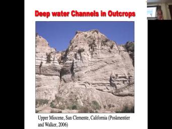
|
| 70:25 | can remember Andrew, you're playing, know, you're doing the Haynesville in |
|
| 70:28 | gulf of Mexico. And he noticed there was kind of like organization. |
|
| 70:33 | had a cutting phase, that kind aggregation of filling phase and that kind |
|
| 70:38 | a back stepping phase, which channel and then the settlement spills out and |
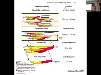
|
| 70:43 | somewhere else. Right. He also that there was a distinct hierarchy where |
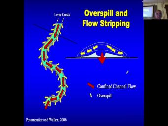
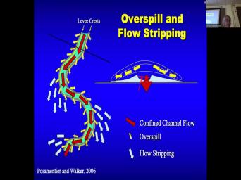
|
| 70:49 | smaller scale channels built into these channel that in turn build the largest scale |
|
| 70:56 | fans. Okay. And now you'll to notice that you've got the channels |
|
| 71:02 | this diagram, you've got organic rich that tend to be below and above |
|
| 71:08 | channels. We haven't talked much about condensed sections yet. Right. But |
|
| 71:11 | got submarine channels, we've got the basin store fans, which I'll review |
|
| 71:16 | in just a sec. And we've the channel levy complex, which is |
|
| 71:19 | muddy fans. Then we've got debris and mass transport complexes. And then |
|
| 71:24 | got these condensed sections. Okay, gonna make, we're gonna we're gonna |
|
| 71:28 | all those to build up a stack submarines, photography and eventually going to |
|
| 71:35 | that back to systems tracks and sea change. So that's kind of where |
|
| 71:39 | going to head and much like much these, these guys noticed in the |
|
| 71:48 | fan, where the more proximal areas deep channels and canyons. And the |
|
| 71:54 | areas have these debris flows and and and and relatively pancake like fans mike |
|
| 72:03 | , very similar geometries with large stacked channels approximately and is gorgeously you get |
|
| 72:11 | land shaped lobes with much much smaller . Okay, this is a bit |
|
| 72:18 | review should be. This is a bit of information on how turbidity currents |
|
| 72:24 | . Okay. I'm not going to the mechanics the shear stresses, all |
|
| 72:27 | kind of stuff, but I just I just want you to understand the |
|
| 72:32 | and scale of the flow versus the of the sedimentary Geum or fix systems |
|
| 72:38 | they build. So here we've got channel with red, showing flow and |
|
| 72:45 | got levies And then the cross section the channel and it shows the |
|
| 72:50 | Here's what gets interesting. Now we the actual stupidity flow and you see |
|
| 72:55 | different between that and the river, ? Half of the stability current is |
|
| 73:01 | the levees. You'd never see that the river. But when the river |
|
| 73:05 | , it may cover the levees by , but gravity just refuses to allow |
|
| 73:10 | water just rise infinitely. It spreads rather than rise vertically. Submarine to |
|
| 73:16 | parents don't operate the same. The of the turbidity currents only a little |
|
| 73:20 | more than seawater. They can They can float. You know, |
|
| 73:24 | haven't got time to give you a on the deposition of turbidity currents, |
|
| 73:28 | they are not like rivers. They are not as beholden to gravity |
|
| 73:33 | river water is because the upper boundary the river is air. Whereas the |
|
| 73:38 | boundary to bring a current is the . Right? And there's there's not |
|
| 73:42 | density difference between the turbidity current and ocean as a consequence, they interact |
|
| 73:46 | in ways that are very different from . So this is a really critical |
|
| 73:56 | because it it forces you to think where the sediment goes okay. So |
|
| 74:02 | a river, where's the core And where's the fine sediments in a |
|
| 74:14 | ? Where's the sand? And where the clay in the river? |
|
| 74:22 | Where is that? In the So spirit, you've got a river |
|
| 74:28 | down here. All right, just a sample of river, Where's the |
|
| 74:31 | , gravel? And where's where's the clay? Oh, no, |
|
| 74:38 | no. In a vertical river profile the bottom, where is the |
|
| 74:45 | It's suspended. Right. And the moves as fast as the current does |
|
| 74:49 | the bed load moves reluctantly dragged along the shear stress of the overlying |
|
| 74:53 | Right. We talked about that in . What is that to do with |
|
| 74:57 | cards? Right, So where's the and activity cards? Where's the course |
|
| 75:02 | going to be in the stability That's right, yeah, it's going |
|
| 75:07 | be in the channel. Right. going to be the area of sand |
|
| 75:12 | gravel of the region. And what's be the in the upper part of |
|
| 75:15 | trip? Pretty current. And with suspended material. Right. That could |
|
| 75:20 | mud, which could be clay silt perhaps very fine sand, maybe in |
|
| 75:25 | bit of fine sand, depending on the ability of the temporary card to |
|
| 75:30 | settlement? Right. So this is understand that the course of settlement is |
|
| 75:36 | in the confined channel bounded by the . Does that make sense? And |
|
| 75:41 | mud is in the upper part of flow. Now, this to british |
|
| 75:46 | is constantly spilling over its levees all time. I mean, maybe sometimes |
|
| 75:52 | entire committee currents contained, child, rarely And it's very different to |
|
| 75:56 | right? Rivers flood rarely to pretty flood all the time. So as |
|
| 76:02 | to break the current is flowing What's happening to the month? Where |
|
| 76:08 | that going? 40 mm hmm. . And it's depositing these levees Building |
|
| 76:18 | 300 m. Building up 300 m relief. Right. That's why the |
|
| 76:22 | are so high because their their their all features built by all this suspended |
|
| 76:29 | and the fine sand that's spewing out the out of the out of the |
|
| 76:33 | . Okay. And the sand continues be confined within the channel. And |
|
| 76:40 | me ask you another question, what to the ratio of mud versus sand |
|
| 76:46 | the turbidity current as it flows down , this levy channel? What is |
|
| 76:53 | ratio of sand versus mud as it down the channel? Does it increase |
|
| 77:04 | decrease? I agree with that. sand is confined inside the channel can't |
|
| 77:24 | the levy. Is that the credit is delivering its suspended load to the |
|
| 77:29 | and building it up. So what's losing? And what's it keeping? |
|
| 77:37 | so the ratio of bed load to load, Does it increase or decrease |
|
| 77:41 | severity? Current flows down the It increases. What about rivers? |
|
| 77:50 | , so very, very different Right, okay, now you're on |
|
| 77:54 | page with me. Of course, other thing that happens is flow |
|
| 77:58 | Right? So the turbidity current moves the corner. The confined channel moves |
|
| 78:03 | the corner. But the unconfined thing going the straight line And that's even |
|
| 78:09 | loss of the upper part of the pretty car. Which means that the |
|
| 78:13 | load to spend load ratio keeps That makes sense. And so when |
|
| 78:24 | get a when you get these turbidity moving around the sinuous curves that constantly |
|
| 78:31 | their suspended load onto the levee and lose them by deposition of clay as |
|
| 78:37 | as the deposition of these crevasse Now, if they breach the |
|
| 78:40 | maybe a bit of sand can get . Right. So but but it |
|
| 78:44 | be only the sand in the upper of the flow that the basal sand |
|
| 78:47 | be retained. And you get what's flow stripping, which means the flow |
|
| 78:53 | the upper part of flow literally separates the sinuous part of the flow at |
|
| 79:00 | degree. That's very different from from . Okay. The other thing is |
|
| 79:05 | general, what's happening to the discharge the turbidity currents as it goes downstream |
|
| 79:19 | it's losing water. What happened to discharge? It decreases. Right? |
|
| 79:29 | , there is my sausage example of play now. And here are some |
|
| 79:34 | I took on a field trip to I was on holiday in Barbados but |
|
| 79:38 | I'm I'm a geology nerd, I on holiday and I go take photographs |
|
| 79:43 | rocks and what's the net to gross that sandstone of that unit there. |
|
| 79:51 | , what's the percentage of sand versus that? Outcrop for photograph? That's |
|
| 79:56 | pretty good reservoir. It's horrific. ? So these channel levy these over |
|
| 80:01 | plays can be quite sandy. forget this. These are distant. |
|
| 80:09 | are distance plays the digital turbine your classical much more money systems. |
|
| 80:14 | ? So those are beyond the distal of the fans. An example from |
|
| 80:18 | . Nice Obama sequences. And an from these are Neo Protozoa IQ submarine |
|
| 80:27 | from Jasper Alberta, aren't you going ? Yeah, check out the submarine |
|
| 80:33 | if you like. Okay. And here's a lovely seismic example that shows |
|
| 80:38 | couple of things. Look at the of the channel as you go |
|
| 80:42 | What's happening to it? That's the of discharge. And then at some |
|
| 80:48 | . So what? So this here's the deal. If the discharge |
|
| 80:52 | the two pretty current gets less and less, what happens to levy height |
|
| 80:56 | you go down street and eventually it no longer confined to bed load. |
|
| 81:02 | that point, the bed load starts like a like a hose. |
|
| 81:07 | And then you get this frontal splay lovely lobe of just rich, |
|
| 81:12 | rich sound. That's another submarine Sweets ball. Okay, now, |
|
| 81:18 | you've got a channel levy complex. the point where the levee gets too |
|
| 81:22 | to confine the sand. You get frontal splay. Yeah. People |
|
| 81:37 | Sorry, say again. Yeah. right. we are. It depends |
|
| 81:51 | how terrific they are. I that's not going to be a good |
|
| 81:56 | . Now, it's got a low right? Because you've got lots of |
|
| 82:00 | , but so probably not great I wouldn't think the content section is |
|
| 82:05 | to be the best seals. And here's another example. So this |
|
| 82:11 | the family saw before and see this bedded, high energy faces. Then |
|
| 82:16 | the channel, it becomes unconfined and get this nice lobe of sand, |
|
| 82:23 | still channeling in it. But it's it's more sandy channels than channel |
|
| 82:27 | Right. And this is what this what these look like in outcrops. |
|
| 82:31 | is the carboniferous ross sandstone in this is this is carboniferous in |
|
| 82:40 | Uh, they don't use the Pennsylvanian , but I think these are these |
|
| 82:46 | the Murray in which I think is . Anyway, okay, and here |
|
| 82:51 | some probable frontal splay deposits in And these have been well documented in |
|
| 82:58 | small submarine fans in South africa. , close to Cape Town. And |
|
| 83:07 | done outcrop work scoring. And these of these fans and they're quite |
|
| 83:14 | they're quite small, so only hundreds feet thick for hundreds of meters |
|
| 83:18 | So the kind of almost shallow marine sequence scale, but they're these are |
|
| 83:25 | source distinct systems. So they're not to the big submarine fans, but |
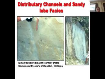
|
| 83:31 | maybe give us a small scale example of how the fans grow and decay |
|
| 83:36 | . So we have a series of coarsening fan deposits, then they kind |
|
| 83:40 | stabilized and they fade. Let me another upper questioning fan deposit, then |
|
| 83:45 | over land by shale, another upward fan deposit. And these these are |
|
| 83:51 | frontal, splay dominated fans. These too small to develop these massive channel |
|
| 83:56 | complexes. And then we see this the same expansion aggregation and and retraction |
|
| 84:04 | the fan in the examples from the basin. The cores look remarkably like |
|
| 84:12 | marine cores that I've looked at in Canada and and the state and and |
|
| 84:17 | the U. S. But there's differences. So they made a point |
|
| 84:33 | yeah, so this is the base they've got these inter fan mud stones |
|
| 84:39 | those look like they have no sand them. So that's the condensed |
|
| 84:43 | Then you start to get this heh face, even lots of great and |
|
| 84:46 | stone beds right now, most people would be a slope forming unit. |
|
| 84:51 | call it a mud stone. And would put the little logical base of |
|
| 84:55 | Fan right there. But they point that the actual base of the fan |
|
| 84:59 | in this horrific faces. We see same thing in the Faron and the |
|
| 85:03 | right that the horrific faces are fed the turbidity currents because they're terrific. |
|
| 85:09 | produce slopes and so in mapping seo cliff is the basis of the |
|
| 85:14 | but in fact the genetic base is a bit lower. And of |
|
| 85:18 | when the fan is retrograde retrograde again, you see at the top |
|
| 85:23 | these much more massive sand stones, would be your maybe sandy debris flows |
|
| 85:28 | you like the Shanmugam model. But , the fan is over land by |
|
| 85:33 | terrific phases, which means it's still current lead, it's just getting more |
|
| 85:38 | and then we get the inter mud stones, which show no evidence |
|
| 85:42 | sand deposition at all. So that's pelagic rain, right? Those could |
|
| 85:46 | organic rich. Those are your And those are also potentially your source |
|
| 85:50 | . Okay, again, the fans very small. So they uh there's |
|
| 85:58 | 20 kilometer scale there. So these are maybe 20 kilometers by 20 |
|
| 86:03 | whereas the amazon is 300 km by km. Right? So, different |
|
| 86:08 | system. This is an example of dip section through the fan. So |
|
| 86:14 | clearly showing an aggregation allele to pro aled geometry, then it lifts up |
|
| 86:20 | then it retro gates. Now, interesting is If I'm in 300 m |
|
| 86:26 | , If I'm in a 1000 m water and I deposited 20 m thick |
|
| 86:31 | deposit, what's the water dash? 1000 liters of water a deposit, |
|
| 86:38 | 20 m fan, what's the depth depth change. What's the new water |
|
| 86:50 | I put 20 m of sediment in 1000 m of water. Wait, |
|
| 87:00 | right, Yeah. So we we 20 m. I'm in a 1000 |
|
| 87:05 | of water. I just dumped 20 of sediment on the sea floor. |
|
| 87:09 | the water? The new water 9 80. I'm still in about |
|
| 87:14 | m of water. Right, let's that I'm in a 20 m deep |
|
| 87:18 | and I put a 20 m thick delta there. What's the new water |
|
| 87:29 | I'm in. I'm on a shelf 20 m water depth. A probate |
|
| 87:33 | 20 m thick delta. Now, the new water dance Zero? You |
|
| 87:38 | the difference right? In shallow marine , the environment has changed profoundly with |
|
| 87:44 | a few tens of meters of deposition a submarine fan. 20 m, |
|
| 87:49 | still in the thousands of m What that means is the accommodation is |
|
| 87:53 | infinite. And so you can fully both the pro gravitational aggregation of recreational |
|
| 87:59 | . Much more so than shallow marine . This is a strike section. |
|
| 88:04 | looks exactly the same as the dip except now it's laterally growing, degrading |
|
| 88:10 | then laterally contracting is the back Okay. Nevertheless, uh, they |
|
| 88:16 | these proclamation a lag rotational retro So they're they're they're getting into the |
|
| 88:20 | idea of accommodation successions or paris sequence patterns and ultimately you can say, |
|
| 88:26 | something has changed, other supplies, stabilizing or decreasing or maybe the staging |
|
| 88:33 | pushing forward, then it's stable and it's retro grated. Right? So |
|
| 88:38 | , this could be a seat out control. And so here they put |
|
| 88:43 | relative speed of the curve and suggests these, these patterns of pro gradation |
|
| 88:48 | , retro gradation retro gradation in in these uh Cape Town South african |
|
| 88:56 | fans. They are assumed to be to sea level. Now, the |
|
| 89:00 | side is these things I believe I think this is Perma Triassic |
|
| 89:19 | Yeah. And the Permian is is paleozoic ice age. So we know |
|
| 89:26 | there was high frequency, high amplitude level changes going on when these fans |
|
| 89:31 | being deposited. So we should expect see lots of cyclist city jake. |
|
| 89:41 | just some examples of, again, a bit of settlement ology. Because |
|
| 89:44 | do love sediment ology. Okay, confess. And again, once |
|
| 89:49 | Angela, I'm I'm in Barbados drinking back spear and taking photographs of, |
|
| 89:54 | was like, well, look at things. And part of what happened |
|
| 89:57 | I was a grad student at the and I just finished a graduate course |
|
| 90:00 | deep water sedimentation roger walker didn't mention word about turbo lights and Barbados and |
|
| 90:07 | was there because ah, okay, been personal, this is my first |
|
| 90:14 | at the time, we were three years. didn't work out. |
|
| 90:17 | met Cindy, we've been married 31 , so, you know, |
|
| 90:20 | I'll let you digest that information. you know, the point is I |
|
| 90:24 | taken this course in deep water Haven't heard a word about Barbados |
|
| 90:30 | I was a bit jealous of all my friends who worked on carbonates because |
|
| 90:33 | all got they all got to go tropical environment. I thought man turbine |
|
| 90:38 | in Barbados. What a great place do. Field work. The people |
|
| 90:42 | nice. There's not a lot of selection, but banks here is pretty |
|
| 90:46 | . And you get to work on beautiful tropical island. And uh you |
|
| 90:50 | , I took these photographs decades But here's the base of the |
|
| 90:57 | I'm not sure I fully appreciate at time, but it's a sand on |
|
| 91:02 | contact. It's got kind of a curving look to it. It's got |
|
| 91:05 | poorly sorted sediment but it's got very clearly finding upward. But man is |
|
| 91:12 | stratification vague. It's like poorly stratified horizontally stratified. The horizontal stratification suggests |
|
| 91:20 | the upper flatbed part of the of bed form phase diagram. Not across |
|
| 91:26 | to be found right across beds. hours to form. And they tend |
|
| 91:31 | be inhibit their their formation tends to inhibited, inhibited when the sediment concentration |
|
| 91:36 | very high. You can also see examples of soft sediment deformation, |
|
| 91:44 | And that's characteristic of extremely high percentages water being trapped with the sediment. |
|
| 91:50 | of this speaks to extremely high rates sedimentation. Okay. And also I |
|
| 91:56 | want to go into details, but are super critical flows. They've got |
|
| 92:00 | numbers greater than one and they produce sorts of weird bed forms, anti |
|
| 92:05 | , back set stratification stuff that you don't ever see in rivers. |
|
| 92:10 | So there's lots of differences between the sedimentary structures and deep water systems versus |
|
| 92:17 | . Here's an example of coarse grain from California. You know, it's |
|
| 92:22 | scour surfaces look so similar. You , they're they're steep, they undulate |
|
| 92:27 | you you can certainly see with the of faith some stratification that man, |
|
| 92:32 | poorly sorted. There's no dunes or no cross beds that are formed by |
|
| 92:38 | . It's too coarse to form ripples they have a very distinctive look to |
|
| 92:44 | . Okay, so, oh, is definitely time for a little breather |
|
| 92:58 | . I'm going to show the I I'm not sure if these are the |
|
| 93:03 | important slides, but you will you be examined on these. So, |
|
| 93:07 | led you along, I'm gonna explain last four slides, Sorry, it's |
|
| 93:14 | the last four slides. It's the few slides and then I'm gonna go |
|
| 93:19 | and make some points about about just of reinforce, you know, a |
|
| 93:24 | about the sequence photography of submarine So we've got so we've got these |
|
| 93:58 | fan or condensed section shales and we've a variety of mass transport complex includes |
|
| 94:06 | slides and debris flows. We've got frontal displays, which is where the |
|
| 94:11 | , the levy is so low that can't contain the bed load in the |
|
| 94:17 | and it starts to spew like a . We've got over bank deposits which |
|
| 94:23 | which of the, the form the channels. Of course we've got the |
|
| 94:30 | and then we have the canyons that them. Okay, so let's think |
|
| 94:35 | kind of shuffling these that I made point that you can get extremely high |
|
| 94:42 | instead of associate with submarine fans, when the sediment supplied by failure of |
|
| 94:47 | slope as opposed to directly fed by river. The accommodation is essentially infinite |
|
| 94:53 | when you're in, You know, km of water tap, you |
|
| 94:57 | even a 300 m high channel levy that you're in 5000 minus 300 now |
|
| 95:02 | in 4700 m completed water death. ? So you can get a lot |
|
| 95:07 | relief on submarine fans. Now, post materials, a big fan |
|
| 95:13 | of changes in topography and changes in can cause too pretty to slow |
|
| 95:20 | And if you're in the gulf of , you get these mini basins that |
|
| 95:23 | caused by area of salt withdrawal. turbine to beauty, current flows suddenly |
|
| 95:27 | in this, in this mini basin , so it kind of slows down |
|
| 95:30 | fills the hole with whatever it's And then once the whole feels it |
|
| 95:35 | spill and fill the next hole that of speaks to the to the to |
|
| 95:40 | the nature of of sediment in these and spill many basins in the gulf |
|
| 95:45 | Mexico. And it's not the only where fill and spill occurs. In |
|
| 95:50 | , you can get sediment reworking by marine currents, making contour rights. |
|
| 96:01 | . There are some diagrams. I've you three or four times because we're |
|
| 96:05 | the end of the class and I'm talking about deep water. I'm |
|
| 96:07 | show these once. But if you know, if we had more |
|
| 96:10 | , I'd probably show them to you . It took me a while to |
|
| 96:15 | this this this figure, figure it . But I've given the fact you've |
|
| 96:21 | most of my questions correctly today, think you'll be able to make sense |
|
| 96:24 | it. So the highest thing you see is the blue line. That's |
|
| 96:31 | scent about ratio santa madre show. ? But Dennis, I already asked |
|
| 96:36 | what happens to santa mud ratio when turbidity current, when the bed load |
|
| 96:41 | confined in the channel and it's losing mud to the levy. That's what |
|
| 96:47 | see. Right? The santa mud was increasing now, as soon. |
|
| 96:54 | , so that's that explains that point . But then see what of that |
|
| 96:59 | more distal of that? The sand mud ratio decreases. Okay, where |
|
| 97:04 | that happen? Where does that Okay, so you've pretty well got |
|
| 97:35 | at the point where the levy can't the bed load anymore. Now we |
|
| 97:39 | to lose bed load. We're also some mud to write, but in |
|
| 97:44 | we're losing the bed load, just go. So that dumps out and |
|
| 97:48 | course the mud keeps on going. now we get the more classic the |
|
| 97:52 | just gets fond of C would eventually it just just it just fades into |
|
| 97:58 | classical turbine ites where the mud is to go a bit further and we |
|
| 98:02 | just lost the sound by that Okay, the dashed and dotted line |
|
| 98:08 | the total flow height and emphasis. The blue dash line is the levee |
|
| 98:15 | . So that emphasizes the point that on that the overall height of the |
|
| 98:20 | decreases, right? So that's the and dotted line. So in general |
|
| 98:24 | entire temerity current is losing sediment as flows downstream. However, it mostly |
|
| 98:31 | clay first or suspended load and it its bed load. So the dotted |
|
| 98:37 | line represents the effective height of the density sandwich part of the flow. |
|
| 98:44 | it does lose a bit of sand not much. So it's holding most |
|
| 98:48 | that sand is confined by the But as soon as the is the |
|
| 98:53 | line which the levee height drops below height of the Sandridge flow or the |
|
| 98:59 | density flow. Then you and you're confining some of the bed load but |
|
| 99:04 | all of it and that's when the load is able to start. Uh |
|
| 99:08 | losing it much more rapidly. That's . I've explained all the three lines |
|
| 99:16 | that curve. Right? So the timidity, the overall discharge which is |
|
| 99:22 | discharges the flow depth of flow And and we talked we talked about |
|
| 99:26 | height with deputy currents because you know they sort of they do actually sort |
|
| 99:29 | float above the above the the sediment interface, they float above the |
|
| 99:35 | And of course the flow height is because some turbidity flows are small and |
|
| 99:40 | are very big. Right? So variation integrity current discharge can be quite |
|
| 99:45 | in between different flows and some of may be controlled by seasonality. Some |
|
| 99:50 | them may be controlled by sea level some of them may be controlled by |
|
| 99:54 | triggers stupidity currents, like earthquakes. are you good with that diagram? |
|
| 100:00 | that make sense? Okay, and sort of explains the sort of the |
|
| 100:07 | attributes and the sand mud contact of of the of the turbidity current as |
|
| 100:13 | flowing down this channel levy complex. down here it's depositing a a frontal |
|
| 100:22 | approximate to that it's depositing a channel complex. So now we've got |
|
| 100:30 | Okay, so this is a pretty boundary. Right? The band between |
|
| 100:34 | channel levy complex and the frontal display boundary could move with time and depending |
|
| 100:40 | where that boundary is, you're gonna frontal splay possibly overlaid by channel levy |
|
| 100:48 | . Maybe the channel, you Or one thing. This diagram shows |
|
| 100:53 | the that that that that the frontal occur at the digital part of the |
|
| 100:58 | and as the system evolves that they it pro grades, then the channel |
|
| 101:03 | complex will build over the frontal Back in the peter vale days, |
|
| 101:11 | frontal slaves were called basin floor fans the channel levy complexes were called slope |
|
| 101:17 | . Right. And that's what you in your accommodation exercise. So Henry |
|
| 101:26 | us that the same dog guy we saw. Okay. And he's just |
|
| 101:31 | off the mostly mostly taken off the mud ratio. So here we've got |
|
| 101:39 | all of a sudden Now we've got tracks appearance. We've got an |
|
| 101:46 | early low stand. We got a low status. So Henry suggested in |
|
| 101:51 | early low stand, the submarine fan barely developed. It takes time to |
|
| 101:55 | up the channel levees, right. need successive turbidity currents to build up |
|
| 102:00 | topography as a consequence, that critical point from channel, every front display |
|
| 102:08 | fairly approximate in the system as the levy builds up. That point migrates |
|
| 102:15 | . Right? So in general, we see is procreation of the muddier |
|
| 102:19 | levy complex over these frontal splits just a function of time. That's because |
|
| 102:25 | takes time to build up the relief the channel levy complex, it just |
|
| 102:29 | there to begin with right? You , you get dropped the sea level |
|
| 102:33 | nick point. So the first kind fans are going to build are probably |
|
| 102:37 | to be more sandwich. And then muddy channel levy will build over that |
|
| 102:42 | splayed. And we see that pattern and again in many of our |
|
| 102:47 | Right? Uh you know, we that in this example here when we |
|
| 102:58 | kind of the the sandy, the laterally extensive sandy uh um front display |
|
| 103:05 | then we get the more organized channel building on top, right. We |
|
| 103:10 | that pattern in many, many, modern submarine fans. In fact, |
|
| 103:14 | we see that pattern, Henry suggested must be controlled by something that's external |
|
| 103:20 | the system. So he suggested that to where we are in the system's |
|
| 103:28 | . So the early low stand is sandy. The later low stand is |
|
| 103:31 | muddy. Now this is you got complicated diagram, but I think if |
|
| 103:40 | think about it, it makes So what he's got here on the |
|
| 103:46 | axis is the curvature of the shelf slope transition. Okay, what is |
|
| 103:53 | point? Okay, what he's saying if there is no choke points, |
|
| 104:00 | , then the deposition of the sandy occurs in a more seaweed position. |
|
| 104:05 | choke born is fairly smooth, it start to migrate landward and the more |
|
| 104:12 | higher the curvature, the more landward the more proximal, the choke point |
|
| 104:19 | . It's a very simple concept, ? The sooner you hit the checkpoint |
|
| 104:23 | the more aggressive that checkpoint is, sooner you'll start to dump sand. |
|
| 104:29 | the red represents the frontal splay, black line represents the levee channel and |
|
| 104:35 | he says is if the curvature is then the choke point is more effective |
|
| 104:41 | starts to force stand to dump sooner the system and in a more approximate |
|
| 104:46 | . Does that make sense? and the importance of the slides that |
|
| 104:50 | us right back to what I told on the very first day about the |
|
| 104:54 | of choke points. So all Henry doing is explaining how choke points and |
|
| 104:59 | the actual shape of the choke point the choke zone control where you get |
|
| 105:03 | frontal splay. So you can look a seismic line simply simply map the |
|
| 105:09 | the seismic line depending on on the , you can say, oh I |
|
| 105:14 | expect that the the front displays to more proximal in the cross section or |
|
| 105:21 | distant the cross section and that tells where your where your best reservoir sands |
|
| 105:28 | . Okay then on this cross section the X axis, he's got settlement |
|
| 105:37 | . So he's got high sand on right and low sand on the |
|
| 105:41 | Okay, so now he's integrating both and the type of settlement being |
|
| 105:47 | So in California, a lot of submarine fans represent reworked beach deposits. |
|
| 105:54 | the very sandwich in the Mississippi, represent depositions from the Mississippi system, |
|
| 106:00 | is very mud rich. Okay, it's a sandwich system and you've got |
|
| 106:05 | highly curved chokepoint. The sound occurs much more landward to the point where |
|
| 106:10 | the, maybe it's impossible to even a channel every system. And of |
|
| 106:15 | , if you've got a sandwich system you have no choice point, then |
|
| 106:19 | sandy faces occur a little bit more , but still more approximately than when |
|
| 106:24 | got a mud system. That makes . So it's just showing how the |
|
| 106:34 | of the, of of of the and base the floor break as well |
|
| 106:38 | as well, whether on the submarine are supplied by more muddy versus sandy |
|
| 106:44 | where the contact between that that frontal or the old basin floor fan |
|
| 106:58 | Okay. Almost the last conceptual This is another Biggie, an important |
|
| 107:05 | . So I'll take the time to it. It's not a particularly complicated |
|
| 107:10 | and it ain't perfect, but it's some good concepts in it. So |
|
| 107:18 | we've got is an accommodation curve with sea level and low sea level. |
|
| 107:24 | , and here's a low stand interval into our high stand. We got |
|
| 107:28 | high stand. Then we've got a stage and low stand, transgression, |
|
| 107:33 | standards. A diagram we've seen 100 . Okay, He does show relatives |
|
| 107:38 | hard at the end versus the So you probably have some subsidence in |
|
| 107:41 | curve. Right? So if this really an accommodation curve, then what's |
|
| 107:46 | this stuff on the bottom here? got our elements that I keep talking |
|
| 107:50 | . There's the condensed section, there's mass transport complex ground for frontal |
|
| 107:59 | green for levy channels, another mass complex and another consent section. |
|
| 108:07 | so Henry and Roger and I would more Henry says, look at the |
|
| 108:11 | , high, high high stand, know, there's there's nothing there to |
|
| 108:14 | sediment. You gotta condense section. ? So the high sea level times |
|
| 108:20 | , you know, that's the old marvel when when you're in your ultimate |
|
| 108:23 | stand, your maximum flooding surface, basin, the deep basins receiving not |
|
| 108:28 | much organic material of the clay. we then see our drops. |
|
| 108:35 | when sea level drops, we release pressure, right? That can cause |
|
| 108:41 | system to mechanically fail. Right? can generate a mass transport complex and |
|
| 108:48 | and when you excavate a submarine typically you get a slump, you |
|
| 108:52 | a knick point and then the river find its way into that slump |
|
| 108:56 | Okay? So he suggests that when sea level is falling rapidly were rapidly |
|
| 109:02 | the pore pressure and that can cause of the shelf edge and and that |
|
| 109:06 | generate mass transport complexes and maybe some currents, then the system kind of |
|
| 109:15 | . But at the early low going back to these diagrams, the |
|
| 109:20 | thing gets deposited the frontal splay, then later it's over land by channel |
|
| 109:26 | complex. So in this diagram, start with the frontal splay and the |
|
| 109:31 | levy complexes a bit later, then start to rise sea level and we |
|
| 109:38 | up the slope. Now we're adding onto the slope. He suggests that |
|
| 109:43 | another period of sediment failure so we get more mass transport complexes building on |
|
| 109:50 | of the channel levy complex. And when she gets to its highest |
|
| 109:55 | we go back into a condensed So he suggests that these main architectural |
|
| 110:03 | condensed sections are at the highest of high stands. The mass transport complexes |
|
| 110:08 | with the times when sea levels changing , so that triggered by rapid fall |
|
| 110:13 | rapid rise. And then the early stand is when you get your front |
|
| 110:18 | and then the late life stand is you get your your channel levy |
|
| 110:22 | Okay, Henry did not make this based on something out of his |
|
| 110:29 | I do like Henry, your But Henry has the amazing ability to |
|
| 110:34 | based on a rather small number of , but his examples are always |
|
| 110:42 | So here's we've seen this cross I've shown it several times, you |
|
| 110:46 | , and here on the cross there's our there's our channel faces, |
|
| 110:52 | , there is a channel or a channel, there's our frontal splay. |
|
| 111:02 | , here we've got, sorry, , there's a frontal splay there. |
|
| 111:07 | got a mass transport complex. that's that thing there. So he |
|
| 111:13 | that the first thing you see is mass transport complex, then a frontal |
|
| 111:17 | , then a channel levy complex and a condensed section, drape, |
|
| 111:22 | sorry. And then there's another mass complex in here. So the observation |
|
| 111:26 | mass transport complex, frontal splay channel camp complex. Another mass transport complex |
|
| 111:34 | a condensed section, all in order the idea that it's reflecting a cycle |
|
| 111:41 | sea level. So he he would this vertical stack of architectural elements or |
|
| 111:48 | positional components of the submarine fans is to changing sea levels. Okay, |
|
| 111:58 | there's a proviso, okay, currents and mass transport complex can be |
|
| 112:04 | by earthquakes at any time, regardless sea level change. So, submarine |
|
| 112:10 | tend to be but noisy in that , right? They can suddenly fail |
|
| 112:13 | of whether it's a pissy level below level. And notionally, you |
|
| 112:17 | there could be triggering a social with level rise, but, you |
|
| 112:21 | a little stuff on a fault, can trigger it to bring the |
|
| 112:25 | Okay, so the last thing I to talk about, It just makes |
|
| 112:34 | one kind of final point. I'll a few slides to make it. |
|
| 112:39 | , and you know, can find basins, you've got them in Nigeria |
|
| 112:45 | you've got mud withdrawal basins, you've them in the gulf of Mexico. |
|
| 112:49 | of places in the world have these these many bases. Okay. And |
|
| 112:55 | basis Phil, once they're filled the gravity flow processes spill in the next |
|
| 113:01 | . Seaward, salt basins are commonly tectonic in which you put sediment in |
|
| 113:07 | basin that presses down and causes more to withdrawal. Right? So you |
|
| 113:11 | sort of get a you can get conversation between the loading of the sediment |
|
| 113:16 | withdrawal of the salt. So you've this kind of self perpetuating system. |
|
| 113:23 | , there may be Alice psychic controls . C. Level that's required for |
|
| 113:29 | to get to the base. So , I'm not saying I'm the best |
|
| 113:36 | guy in this. But there was very interesting consortium. Study Bunch of |
|
| 113:41 | companies, bunch of academics and they at a series of four mini |
|
| 113:46 | Okay. Base one two three. was four. Alright, uh |
|
| 113:55 | Basin three is here I think. , going from onshore to offshore and |
|
| 114:03 | did heart resolution. Seismic of these . And of course they also have |
|
| 114:07 | well constrained sea level curve from the 120,000 years. And we've seen this |
|
| 114:13 | when we talked about delta's right. now we're gonna come back to the |
|
| 114:16 | system. Gulf of Mexico the same level curve a step forth progression. |
|
| 114:21 | , very well calibrated. They've got , they've got age dates. And |
|
| 114:26 | they can say exactly when each of four bases filled one bases close to |
|
| 114:32 | slope break. So sorry to the floor break. And basically for is |
|
| 114:38 | farthest away. Okay. And they a series of cores and a series |
|
| 114:43 | cross sections. So here's an example what the seismic looks like. |
|
| 114:49 | And here's what the well logs what the courts look like. And |
|
| 114:53 | they have a series of sequences Unit , 2, 3, 4, |
|
| 114:57 | and six. Okay. Um and course, in addition to to the |
|
| 115:09 | sequence photography of the mini basin, Anderson john suter and many others have |
|
| 115:17 | an extremely good job of mapping the onshore systems on the shelf of the |
|
| 115:25 | . They've met the low stand they've met all the The 4th Progressive |
|
| 115:29 | Low Stand Canyons and they cannot link canyon for canyon delta delta with their |
|
| 115:36 | water based in many fields. So an extremely well calibrated source to sync |
|
| 115:42 | and they've got falling stage low stand transgressive systems tracks. Okay, this |
|
| 115:52 | I find very compelling. Okay, this shows hemi pelagic versus uh non |
|
| 116:04 | pelagic. So the hemi pelagic sediment stuff that's just floating in the |
|
| 116:11 | The non hemi pelagic system is a coming from land. Okay. And |
|
| 116:17 | demonstrates in no uncertain terms that at , high stand, there is no |
|
| 116:24 | coming from the land, it's all pelagic at the peak of the low |
|
| 116:29 | and the early transgression, most of sediment is being delivered by rivers to |
|
| 116:34 | deep water. So that diagram tells that it's hard to get sediment into |
|
| 116:41 | deep water unless you've got the river at the shelf edge when the shelf |
|
| 116:46 | flooded, there's no way to get in deep water. Now there's a |
|
| 116:51 | very well respected deepwater guys jake called vault brian romans, Vann Kalla and |
|
| 116:59 | got a couple of exceptional examples of submarine fans and Pete burgess. And |
|
| 117:05 | said well, you know, and always say, well you know by |
|
| 117:07 | large, most submarine fans are active low stand. Oh no, oh |
|
| 117:11 | , no. There's transgressive submarine There's high standard. There's one or |
|
| 117:17 | very special situations, very narrow You know, not in the gulf |
|
| 117:22 | Mexico well, but you know during transgression you get you get you get |
|
| 117:26 | know and when sea levels rise and get you get you get lots of |
|
| 117:30 | fans. No you don't. You're low stands, you get a little |
|
| 117:34 | of rise, the glaciers are The shrine hasn't moved very far discharge |
|
| 117:40 | gone through the roof. Yeah. get a lot of pro gradation of |
|
| 117:43 | branch fans in the late low That is when you static sea levels |
|
| 117:49 | to rise in its early phase. it's ripped back there's no more submarine |
|
| 117:55 | deposition at the true high step maybe the beginning the transgression. Yes, |
|
| 118:02 | I would argue that it's still when systems are still standing low. |
|
| 118:07 | So I think all those academic guys very confused about the definition of systems |
|
| 118:13 | and they're confusing sea level and systems . They're saying well sea levels rising |
|
| 118:17 | you get submarine found procreation which is . So that's transgressive systems track. |
|
| 118:21 | said no it's not. It was defined that babe that way. Not |
|
| 118:24 | john van Wagner, not by pete , not by Henry post material. |
|
| 118:29 | early phase of rise as I've shown encounter slides is considered to be the |
|
| 118:33 | low step. And it's only when get that transgressive surface and that huge |
|
| 118:38 | traditional back step that we define the systems track. It has caused confused |
|
| 118:44 | it means that transgression can occur in early low stand, particularly the valleys |
|
| 118:50 | we discussed anyway. So I like slide because it's an unequivocal data driven |
|
| 118:57 | scoring data that demonstrates that the non pelagic sediment is primarily related to the |
|
| 119:04 | stage. And I'm not going to the mike bloom slide which was almost |
|
| 119:09 | focused on the fraternity valleys. Remember talked about at those peak low |
|
| 119:14 | you get excavation and when the low stops get lateral migration. And so |
|
| 119:20 | get periods when you get sediment stored the valley and sediment when it's being |
|
| 119:25 | and that is exactly represented in what's delivered to the offshore again. Which |
|
| 119:29 | you to make predictions in the valleys the type of sentiment. You get |
|
| 119:34 | submarine fan. Mm. Okay, this is another, if you |
|
| 119:42 | this is kind of a wheeler diagram the photography of these mini basins, |
|
| 119:50 | colored units. Well, we've got , which is our condensed section |
|
| 119:58 | We've got the levee channel, which a light grade, uh, |
|
| 120:02 | we've got the light, we've got distributor rechannel low complex, which would |
|
| 120:06 | the frontal splay in black. That's sweet spot. And then we've got |
|
| 120:10 | transport complexes. Okay, so walker term walker predict that that at high |
|
| 120:19 | you get a drape, then you so you get a drape at high |
|
| 120:24 | , you get a mass transport complex suitable falls and that's over land by |
|
| 120:29 | orI complex. And then a levee , then another mass transport complex and |
|
| 120:34 | drape complex. So what do we in these fill and spill basins. |
|
| 120:41 | here are the most proximal basin and got two cycles of sea level change |
|
| 120:47 | . Right? So we've got this use static cycle than the younger |
|
| 120:51 | So the oldest one. The first we see is a mass transport |
|
| 120:57 | Then we see a drape. so that could be here. Then |
|
| 121:02 | would predict a distributor channel complex. it is. Then that's overline by |
|
| 121:08 | mass transport complex. Then the distributor complex. Then we've got EM TCS |
|
| 121:16 | distribute the complex. Not seeing much the way of levy channels yet. |
|
| 121:22 | . In fact, this system has levy channels. Let's go to this |
|
| 121:26 | . We've got a mass transport then we've got this frontal splay. |
|
| 121:32 | that's over lamed by a drape. sedimentation switched to this one. So |
|
| 121:36 | it's spilling. We get mass transport over land by distributor channel than a |
|
| 121:43 | channel. That sort of fits the here. We get a mass transport |
|
| 121:49 | , distributor channel and then levy Then sedimentation switches to the next or |
|
| 121:55 | most Distal mini basin. And we a distributor channel complex over land by |
|
| 122:00 | channels. One of the things you'll is in general, the most difficult |
|
| 122:05 | always fills last. Okay, early basins fill first, Then the |
|
| 122:11 | base in the next one. The one. And this one has some |
|
| 122:16 | fellows. Okay, This one fills some simultaneous filling basin. Three actually |
|
| 122:24 | get the sediment at all. It's system. Maybe the mini basin wasn't |
|
| 122:28 | because it formed a bit later. then he gets his youngest thing. |
|
| 122:32 | doesn't fit the post material welcome Exactly. But there are elements of |
|
| 122:37 | . So it's a it's a you know, in a perfect |
|
| 122:41 | You'd get post material walker's model. , But an imperfect world. You |
|
| 122:47 | things shuffling around a little bit. . And you know here we've got |
|
| 122:53 | little cross section again, shows these same, uh, the same deposition |
|
| 122:59 | that we talked about. Heavy pelagic , sandy Turpin nights. I don't |
|
| 123:05 | have the mass transport complexes here. they just show how the various, |
|
| 123:11 | the basin fills over time. And I just come back to the |
|
| 123:17 | which to me emphasizes the failure. time you see part of a low |
|
| 123:22 | , you're seeing a bit of a hemi pelagic component. You got a |
|
| 123:27 | stage, non heavy pelagic falling non heavy pelagic falling stage, non |
|
| 123:34 | pelagic falling stages. Non hemi you get a rise, you |
|
| 123:40 | you don't get, you get heavy , you get a rise, you |
|
| 123:44 | hemi pelagic, I mean it's pretty for one, you get the maximum |
|
| 123:48 | . Non hemi pelagic. So this to me shows that there is a |
|
| 123:52 | intimate link between what sea level is and the ability to get sand into |
|
| 123:57 | water. Okay, this has worked some of the european fill and spill |
|
| 124:03 | . Uh, some of these bases so small that integrated current comes to |
|
| 124:06 | basin bounces against the edge of the and reflects back eventually. It can |
|
| 124:12 | over. You can get nick points between one mini basin and another. |
|
| 124:16 | basin and settlement from one mini basin maybe spill out anyway. And that |
|
| 124:22 | produce cyclic Alternations of our, these our standard uh, sedimentary faces. |
|
| 124:31 | then I think we're close to the here. Uh, this is this |
|
| 124:36 | by, by john Anderson. john was interested sources in systems and |
|
| 124:41 | noticed that extremely big doubts like they're so huge that if the Sheriff |
|
| 124:49 | a bit narrow, they can get the shelf edge Within a couple of |
|
| 124:54 | years before the adults, smaller delta can never get, can never cross |
|
| 125:00 | shelf if they're small during an avulsion . So the only way for small |
|
| 125:06 | as to get the shelf is with sea level fall. It was very |
|
| 125:09 | . High Senate supply deltas like the or the Mississippi might be able to |
|
| 125:14 | the shelf out on their own steam . So what that means is that |
|
| 125:19 | big big river systems, continental systems be able to feed some sediment to |
|
| 125:24 | , to the submarine fans during high if they can get there in time |
|
| 125:31 | small systems can never do it. the smaller delta systems on big continental |
|
| 125:36 | never produced submarine fans unless there's a of seal. Big systems may depends |
|
| 125:43 | the, on the ability for for the delta to build across the |
|
| 125:47 | before it switches okay. As well the length of time of the low |
|
| 125:53 | . And when we start looking at , the, the record of paternity |
|
| 125:58 | levels, You know, sometimes the stance last 20,000 years, sometimes they |
|
| 126:03 | a few 1000 years. So it's variable and it's very during geological |
|
| 126:08 | Okay. All right. So there's couple of conclusions there. Uh, |
|
| 126:16 | know, obviously what's staging the material being reworked to supply the submarine fans |
|
| 126:23 | a big control on what kind of being supplied. Some submarines, fans |
|
| 126:27 | fed directly by rivers, other are by failure of the of the |
|
| 126:33 | Okay. And mass transport complexes can debris flows, slumps, slides and |
|
| 126:40 | uh and slumps and slides. They also mix with so much water that |
|
| 126:45 | evolve into a turbidity current and those be much, much, much bigger |
|
| 126:49 | anything fed directly about out of a . Okay. But of course, |
|
| 126:54 | transport complexes and debris occurrence can also triggered by earthquakes that have nothing to |
|
| 126:59 | with sea level jake. There is that fans can show presentational retro, |
|
| 127:05 | aggregation, all stacking and things analogous pair of sequences have been identified mostly |
|
| 127:12 | these smaller sandwich fans. Okay, , slope and physiognomy and particularly the |
|
| 127:20 | of the change of slope which defines curvature of the nick of the of |
|
| 127:26 | choke zone and whether or not it forms a point versus a zone is |
|
| 127:33 | in. And of course the nick same thing in the size and scale |
|
| 127:38 | canyons as well as the position of distributor, the fan load complexes or |
|
| 127:43 | parental displays versus the overlying Maria channel complexes because of indefinite accommodation. The |
|
| 127:50 | levy complexes can build up 1000 ft relief and a big submarine fan, |
|
| 127:56 | that a river could never do. then of course, once you build |
|
| 127:59 | that, that can, that can the channel every complex to laterally |
|
| 128:04 | right? You also have this oughta uh, cyclist city and big submarine |
|
| 128:09 | systems and the, and the ratio sand incentive to play may recollect the |
|
| 128:16 | with respect to the slope, basin bake the length of distance that the |
|
| 128:22 | have to run out the sadness of system and those we discussed with respect |
|
| 128:27 | those diagrams. Okay. Okay. at 3:12. Okay. We |
|
| 128:41 | let's, let's take a break. take a 10 minute break. Maybe |
|
| 128:45 | kind of just take a stretch and , uh, when we come |
|
| 128:51 | Okay, let's, do you know you have any more questions about the |
|
| 128:55 | , we can do that when we back. I mean, I've seen |
|
| 128:58 | lot of your work. I think are doing okay. So I don't |
|
| 129:02 | to worry about that. This is , just tell me what's going to |
|
| 129:10 | right tomorrow brock in Dallas not to available. Okay. I'm driving |
|
| 129:18 | Let me start with the corresponding I love cell phone. So I |
|
| 129:22 | actually protest or something. But I'm break with that. I'm not going |
|
| 129:29 | get to. So uh what's Alright. So it might be or |
|
| 129:39 | can probably do one night. Why pull until the morning at the 11th |
|
| 129:46 | be available? You know, a of hours before exams. You |
|
| 129:55 | pretty bad for accumulated. And that really when I get to. |
|
| 130:09 | It's very you know, for we're the questions sounds reasonable. I don't |
|
| 130:19 | this is probably the last coming Our model recitations facial, the ex |
|
| 130:29 | . Strong. That's the question. . A safe. Right. |
|
| 130:40 | With your exercises. Maybe 15, minutes then, Huh? And are |
|
| 130:50 | alive. I know she must You talk to her. You might |
|
| 130:56 | to just review hers with her. sure she's not making that mistake. |
|
| 131:07 | . All right. Mhm. I state that I have, |
|
| 131:28 | Mark, yep. But you do to put your spasms in, |
|
| 131:35 | I want to see you draw the . You know, I want to |
|
| 131:37 | this idea of a gradation of basin how you're gonna. So just the |
|
| 131:42 | thing that's missing now is just Suzanne's ? So you'll lose a few marks |
|
| 131:47 | . The correlations look fine. I , I might quibble with one or |
|
| 131:50 | , but I would I wouldn't mess those. So, I'd say you've |
|
| 131:53 | a great job at the correlation, would just add in your exams. |
|
| 131:57 | ? So, you know, if do have to put the faces boundaries |
|
| 131:59 | there, right? You know, channels are easy because they're sharp |
|
| 132:02 | but I want you to sort of to superimpose the faces boundaries and the |
|
| 132:07 | on here. So that's the only right now that's missing. So I |
|
| 132:15 | I was gonna kind of mm hmm animal belts. I would leave the |
|
| 132:23 | bounce as they are. And I focus on getting your, so you |
|
| 132:27 | me where the sands are, the , but you haven't really indicated where |
|
| 132:31 | sand is in the, in the shore face stuff. So draw that |
|
| 132:38 | color yellow and then you're done. like where? Oh yeah. So |
|
| 132:59 | was trying to get to the Mhm. Yeah. But does it |
|
| 133:10 | follow the same? Okay. And bloated public? I'm not that sure |
|
| 133:19 | you're asking. The distributors channel erode a delta, right? Usually it's |
|
| 133:24 | to be linked to a delta. don't think that's a purple face beneath |
|
| 133:27 | it, but I can't, I receive, so you might want to |
|
| 133:32 | there is a bit of yellow there . So there isn't, there is |
|
| 133:35 | shore line below the distributor channel and sort of cut a little bit, |
|
| 133:39 | you might want to kind of put little bit of a sham in there |
|
| 133:42 | then put the distributor channel eroding in top of it and that is a |
|
| 133:47 | tricky part to cover. And then see this line here, that's sort |
|
| 133:51 | dipping landward. That should probably be shamisen. Right? So this is |
|
| 134:01 | of a, the correlations are you're just missing, you're missing the |
|
| 134:06 | , right? So that's, you , so I'd probably give you a |
|
| 134:10 | on that. Not because of any . You just haven't really finished the |
|
| 134:14 | . Right? And that and that that's exactly what you should be |
|
| 134:22 | Right? So, yeah, so only concern I have is you haven't |
|
| 134:27 | any spasms yet. So I think want to make sure that, you |
|
| 134:31 | how to do that. You you've got all the correlations are |
|
| 134:35 | You know, maybe that one different landward you might want to think |
|
| 134:40 | maybe that should be a bit more a schism and, but I say |
|
| 134:44 | correlations are great. Very nice Trial belts look great, very nice |
|
| 134:49 | . So you've got the hang of . So I'm not worried that I |
|
| 134:52 | , I do want to see you sure that you understand the season |
|
| 134:58 | It would be good to get some those in before the exam because there |
|
| 135:02 | be a correlation on the exam that you to drive. Just make sure |
|
| 135:06 | that you understand that concept makes That perfect Dennis. Do you have |
|
| 135:17 | questions? Okay, question? Okay, so now we're on to |
|
| 135:28 | two. Um, cr or I go for the question. I'll do |
|
| 135:39 | right now if you like. accommodation is defined as a space available |
|
| 135:45 | sema. In filling content of Graphic base level refers to the equally |
|
| 135:50 | profile that separates definition above from Below. The basic fundamentals of mapping |
|
| 135:56 | restricted is the formation which of these not a formal strata graphic unit |
|
| 136:01 | not formal period stage member formation. formal accommodation is mainly controlled by changes |
|
| 136:12 | tectonic subsidence tectonic uplift. That news see this formal strata graphics scheme that |
|
| 136:18 | changes in the magnetic field is referred as magnetic photography. The maximum funding |
|
| 136:25 | separates the transgression from Hiestand systems tracked bar's owners. Usually I would say |
|
| 136:37 | of years might get a point for of thousands, never thousands. The |
|
| 136:42 | sequences were defined by larry schloss download variety of base lab define a little |
|
| 136:51 | terms para sequence genetic. Lady is genetically linked series of bed sets battered |
|
| 136:58 | a flooding surface systems tract is a of deposition systems or a set of |
|
| 137:05 | sequences that are genetic related, commonly by a systematic stacking pattern and they |
|
| 137:13 | be bounded by either sequence boundaries. , The maximum cutting surfaces. The |
|
| 137:18 | sequence is a genetically related group of bound advice sequence boundaries and the correlative |
|
| 137:27 | . The ratio is the ratio of . A relative to set on the |
|
| 137:31 | S nick points is where the slope , You get erosion choke points where |
|
| 137:41 | slope decreases, get depositions. So cross section of block diagram would suffice |
|
| 137:46 | suffice for that. And then uh the figure we'll see what unit two |
|
| 137:57 | laps and down laps. Unit So I was looking for to their |
|
| 138:01 | like physically on laps approximately. 78989 lap you at six four B. |
|
| 138:09 | laps Unit for a. And you , So Unit four beat down laps |
|
| 138:18 | for a. And you performed for on laps unit two And Unit five |
|
| 138:26 | . Ah On laps Unit three. sorry, five a. truncated unit |
|
| 138:32 | . Yeah, that's right In Unit . P. A. That would |
|
| 138:36 | a high stand systems tracked. You P. A. you know, |
|
| 138:39 | would be today. That would probably a low stand systems track because there's |
|
| 138:44 | faces there. Unit five is a is p. d. degradation. |
|
| 138:50 | that would probably falling stage, you , six would be peter A. |
|
| 138:54 | would be another low stand because it's it's shifted down from five. That |
|
| 139:00 | the answers. That makes sense. . Yeah. Right. Well I |
|
| 139:10 | corrected your quizzes yet but anyway. that fair claire. So unfortunately mm |
|
| 139:29 | . What which one? First Sorry. Which? Oh yeah, |
|
| 139:40 | for each of the units. So a few units Units 1, |
|
| 139:46 | , 5 and six. Yeah. if you elaborate you're probably gonna take |
|
| 139:56 | off. You got the right Right? So yeah, now the |
|
| 140:05 | thing we'll do is have a look the study guide. There we |
|
| 140:42 | Ah my heart study guide. so I've got it up here and |
|
| 141:28 | to answer any questions the way that's what I want on the question, |
|
| 141:33 | the final exam. But I'll show to you, yikes start. Let |
|
| 141:48 | pull it up there again. I it up there and like close it |
|
| 141:51 | open up the final exam by You're quick, it will be recorded |
|
| 141:57 | you'll be able to see the first . So there you go, oh |
|
| 142:02 | . If you don't, if you the first question wrong, I'm gonna |
|
| 142:04 | gonna I'm gonna take five points Normally do that. I'm not going |
|
| 142:09 | change it. So there you There we go. To study |
|
| 142:36 | Okay, go ahead over for kids. Oh, truth. |
|
| 142:56 | So I showed lots of diagrams, know of, I mean the the |
|
| 143:02 | the sequences sequence boundaries are defined by , all discontinuities, right? This |
|
| 143:07 | ease and in valley fills, you , the low stands are typically flew |
|
| 143:16 | . The transgressive is where you get influence and the high stand is out |
|
| 143:21 | the valley, right? You're looking low, low net to gross alluvial |
|
| 143:25 | that's kind of the general model and talked about controls, influential sequences and |
|
| 143:30 | tracks. You know, they're they're by nick points, accommodation, changes |
|
| 143:38 | systems tracks could also be identified by in police calls. We talked about |
|
| 143:43 | most mature Peirsol's Tiffany occur on the . The humid paley souls may represent |
|
| 143:51 | transgressive systems tracked and as you get more mature soils into the so that |
|
| 143:57 | the married right diagrams. So I look at those diagrams pretty carefully and |
|
| 144:01 | like, okay, so what were , you know where the boundaries of |
|
| 144:04 | systems tracks in terms of in terms the stacking of the flu real channels |
|
| 144:08 | belts, whether or not they are by erosion, all surfaces and so |
|
| 144:13 | and so forth. So that's kind what I would look for that. |
|
| 144:18 | might you might want to kind you know, look at that Shannon |
|
| 144:22 | diagrams and be able to kind of that. That makes sense. And |
|
| 144:34 | controls on alluvial sequence Systems track I mean, you could say, |
|
| 144:38 | , you know, full of your is controlled by avulsion frequency migration rate |
|
| 144:43 | subsidence and and also by nick Right. That controls whether or not |
|
| 144:47 | and size. We also talked about buffer profile and upstream and downstream controls |
|
| 144:53 | that you could write a lot about question. What else? Thank |
|
| 145:25 | What about converters. Okay, Right, okay. So do you |
|
| 145:40 | any idea how to ask the I'll let you give me some ideas |
|
| 145:44 | and then I'll kind of experience. she was so pretty soon. |
|
| 146:00 | So I don't know. Yeah. the short answer is the tectonic on |
|
| 146:06 | that results from with dysphoric defamation should angular and conformity. Now the exception |
|
| 146:12 | be I mean the colorado plateau is vertically and so that's actually more like |
|
| 146:17 | dis conformity or nonconformity because the air uplifting is huge relative to the |
|
| 146:24 | Right? So there might be exceptions you don't get you need to get |
|
| 146:27 | angle on before you actually differential tilting opposed to just brought up left. |
|
| 146:32 | . The shorter answer is you I've worked on this like you |
|
| 146:36 | even subtle differential with historic deformation will you an anger on conformity used to |
|
| 146:42 | can never produce an angular and Now you might get planets forming straight |
|
| 146:47 | and a drop of sea level and you might say, oh well there's |
|
| 146:50 | between the client form and the client has a bottom set. The bottom |
|
| 146:54 | flat top of the channels flat, normal and you're in conformity. |
|
| 146:58 | So yeah, that's naturally easier question answer because the the number of it |
|
| 147:04 | is tectonic on conformity is like the gun conformity of Larry's loss are at |
|
| 147:12 | continent wide, angular and conformity? would ever confuse those as being used |
|
| 147:16 | in nature. So is that part it tectonic setting where you're no. |
|
| 147:25 | it was moderately active. You know that could be in place for. |
|
| 147:33 | . Right. So in the cretaceous interior where you have subtle you know |
|
| 147:38 | gave you examples of subtle folds. know some very subtle weird angular and |
|
| 147:43 | ease and and it took a lot work with multiple data is to figure |
|
| 147:47 | that these are angular and conformity And therefore in that paper that I |
|
| 147:51 | the boy and we said these are on conformity and not use static. |
|
| 147:54 | Exxon had interpret them as you You can uh driven. Incised |
|
| 147:59 | But no they're not. You know a big tectonic over print but it's |
|
| 148:03 | . Right? Um In contrast if in a passive margin, can you |
|
| 148:07 | an angle on conforming? A passive ? No. The answer is of |
|
| 148:15 | you can from yeah but you shouldn't everything I say. First of all |
|
| 148:28 | can get rotational tectonics right. A margin rift margin is still passive even |
|
| 148:35 | it's rifting. And worse, I you an assignment of a passive margin |
|
| 148:43 | there's a big slump with rotational growth . That's neo tectonics not plate tectonics |
|
| 148:49 | I asked you to find our angular . It's a marine on conformity that |
|
| 148:55 | the flatline Hiestand sediments over your rotated blocks. Right. So but they're |
|
| 149:00 | there but they're neo tectonic not plate . Right. So you know you've |
|
| 149:05 | to be able to resolve all those ? United's geologists, reality is always |
|
| 149:14 | complicated than theory, Right? So , so you can get anger and |
|
| 149:20 | on passive margins, but they tend be very common. The rift phase |
|
| 149:25 | the drift phase it can be less . But you can get subtle rotation |
|
| 149:28 | some public. Right? But but but again, you have to think |
|
| 149:33 | where the rotation is occurring. What can't get is is now you can |
|
| 149:37 | rift shoulder uplift right in in the phase. You really can't get up |
|
| 149:42 | in the drift. A so once adrift, you know, you could |
|
| 149:45 | down, you could differentially tilt but can't really uplift, right? |
|
| 149:50 | which makes it difficult to get and own conformity. Because if you if |
|
| 149:54 | subside all you do is blanket You don't get truncation, just get |
|
| 149:58 | lap of the rotated Passive Martin seven . Yeah. So again, could |
|
| 150:06 | distinguish tectonic all basic types? You , in a foreland basin, it |
|
| 150:13 | be harder. The colorado plateau is but it's such a huge area produces |
|
| 150:18 | dis conformity. So you might not if you just saw that massage because |
|
| 150:23 | was a tectonic conformity. Yeah. know, you might find it correlates |
|
| 150:27 | angular discordance elsewhere in the base, ? So you sort of have to |
|
| 150:32 | your wits about you other questions. have the undivided attention of the ego |
|
| 150:42 | to answer all your questions to help . Ace the exam working mm |
|
| 150:51 | Yes. The digital print with the course. Professional. Thanks so |
|
| 150:59 | Yeah. So a normal regression is called a high standard aggression. So |
|
| 151:04 | aggression would be pure P. Or must have a component of A. |
|
| 151:09 | other words, it's driven by high supply. Right? Anytime you got |
|
| 151:14 | , you must have an increased accommodation could be generated by subsidence or by |
|
| 151:20 | level rise or both. To get gradation. The A. S. |
|
| 151:24 | must be less than one. That mean that combination is negative and it |
|
| 151:28 | be positive. Right? As long you've got increased in combination, then |
|
| 151:34 | going to generate ah where are Yeah. Then then you're gonna generate |
|
| 151:42 | combination behind the programming shorelines that's going generate a parabolic tail. So normal |
|
| 151:49 | regressions will almost always have operatic And they will routinely have minimum |
|
| 151:55 | And probably an A. P. P. A accommodation succession force |
|
| 152:01 | It's very difficult to generate a parabolic . Rivers will commonly in size across |
|
| 152:08 | top of the descending wedge. And get down stepping. So, and |
|
| 152:13 | may get a regressive surface of marine if the trajectory of fall is steeper |
|
| 152:18 | the sea floor. So those are are those are how I would distinguish |
|
| 152:23 | from normal regression. So first of , we define it right? Forced |
|
| 152:27 | is a regression that's forced by a of sea level or drop of relative |
|
| 152:32 | level normal regression is where sediment supply high enough to allow the system to |
|
| 152:38 | grade without any drop of sea So accommodation could be static to increasing |
|
| 152:44 | a normal aggression. As soon as goes negative, you're in a forced |
|
| 152:49 | . So that's how they defined a distinguish. It means means understanding the |
|
| 152:55 | of the preservation of the parabolic tail the importance of the sharp bayshore |
|
| 153:00 | which is underlined by the regret. is which is underlined by the regressive |
|
| 153:05 | of marine erosion. That makes Yeah, that's how it how to |
|
| 153:14 | that. And again, in these , the sketch is worth 1000 |
|
| 153:18 | Go back to those diagrams and sort sketch them in your head. That |
|
| 153:21 | be good. It won't be an book exam. So it's going to |
|
| 153:25 | whatever you can right here. What do you have questions about? I |
|
| 153:53 | that 1-4 pretty clear. Those are the exercises you've done. Ah So |
|
| 154:02 | should be pretty straightforward when I say lap on the seismic section. In |
|
| 154:11 | I gave you that you identified lapis a section. So across the word |
|
| 154:14 | , Mcgowan say identify lap out on a a geological cross section. Whether |
|
| 154:19 | a seismic data or whether it's just cross section. Yeah. Yeah. |
|
| 154:29 | be honest with the seismic data doesn't very well. And usually like giving |
|
| 154:32 | clients because I can never read anything . It's just, it's too much |
|
| 154:35 | . So anything else Now? Some these questions will appear in a multiple |
|
| 154:45 | . Like I might, I might , you know, the big contribution |
|
| 154:48 | how it really was. And I'll you some lists or I'll say, |
|
| 154:52 | know, we looked at, you , well I wouldn't say wheelie diagrams |
|
| 154:55 | identified, you know, invented by because that would be, he didn't |
|
| 154:59 | invent it. But anyway, you , and you may find some of |
|
| 155:05 | , that, that if you sort understand these questions, you'll find that |
|
| 155:09 | , there'll be sort of some component be in a definition short answer or |
|
| 155:15 | a, in a multiple choice. . Anything else that you'd like me |
|
| 155:22 | discuss? Anything that you're uncertain or about? What's that? Yeah, |
|
| 155:41 | , yeah, yeah. And like said, you know, if |
|
| 155:44 | you know, look at these um, you know, I did |
|
| 155:49 | quite a bit about deepwater sequence there will be a few questions on |
|
| 155:53 | last lecture I gave today. um, you know, if you |
|
| 155:58 | questions based on the stuff like particularly that you have a chance to review |
|
| 156:02 | text, you know, you you've got my cell phone number, |
|
| 156:06 | can always give me a phone call I'm not driving like an answer. |
|
| 156:09 | I am driving, I'll just say . I can't answer now. Text |
|
| 156:12 | later. Um, and hopefully you'll great. I'm happy with the exercise |
|
| 156:22 | I'm seeing. So that's good. Utah you're not gonna be here Wednesday |
|
| 156:33 | ? Yeah. So I've given you the exam. He will print it |
|
| 156:37 | could you do me a favor and staple it rather than use the |
|
| 156:41 | Just for the final. It's, , it's 10 pages so I don't |
|
| 156:44 | papers getting shuffled or or dropping Yeah. And uh Yeah, I |
|
| 156:52 | there's 20 multiple choice, there's, I forget now 2025 Multiple Choice and |
|
| 157:02 | Answers. And then there's, there be one essay question exactly taken from |
|
| 157:09 | questions as is so one of those will be on the exam. You |
|
| 157:14 | have to answer one of them. tell you which one it's going to |
|
| 157:18 | . Could be one I've reviewed. may not be, but if you're |
|
| 157:22 | through them and go like, I don't really understand this. Just |
|
| 157:24 | me text. You know, I'll my best to answer it. Even |
|
| 157:28 | it's Even if it's only 11th, get you your feedback right? I |
|
| 157:36 | it's like three. Yeah exactly. much are you looking for us to |
|
| 157:43 | about correct. That's true john maybe paragraph or just some bullet points, |
|
| 157:53 | know, right. I do not five pages. I won't read |
|
| 157:59 | If you give me half a page be more than enough. So I |
|
| 158:05 | just say, do a quick paragraph kind of what you think of the |
|
| 158:08 | major tectonic static events, right? know? Yeah, that'd be more |
|
| 158:13 | enough. Uh Anything else? Alright , you are a great class. |
|
| 158:23 | gotta tell you three students is a less work for me than 20. |
|
| 158:28 | ask a lot of good questions. hope you enjoyed it. I hope |
|
| 158:31 | learned something I want you all to well in the final uh and |
|
| 158:36 | I'll be as |
|

