| 00:00 | therapy representative. Yes, You're saying one big screen. Yes, |
|
| 00:08 | Okay, so uh I apologize, couldn't be there, my wife and |
|
| 00:16 | was supposed to leave for texas last and we both got Covid? |
|
| 00:22 | I'm testing negative. She's still testing . Our plan is to leave right |
|
| 00:28 | class tomorrow, so I may want finish around uh 5:00 My time |
|
| 00:36 | which I think you guys are an ahead of us and that will be |
|
| 00:40 | for your time and then the week will be in person. Um that's |
|
| 00:46 | plan. Anyway, assuming that we have any more code of difficulties. |
|
| 00:51 | so the focus of this is this on sequence photography. Um I'm the |
|
| 00:58 | Cunningham Research Chair in geology at McMaster . uh I taught at the University |
|
| 01:04 | Houston from 2005 until 2013 and then head hunted for an endowed chair position |
|
| 01:11 | in Canada. I did my PhD McMaster and Susan Cunningham did her bachelor's |
|
| 01:18 | back in the late 70s. She the Vice President Exploration for Noble |
|
| 01:23 | which is where she made her millions decided to fund an endowed professorship at |
|
| 01:29 | And I was very happy to be to take up that position almost 10 |
|
| 01:33 | going out. So our class is to run for the next three |
|
| 01:37 | I believe you're midway through your I'm going to ask you to talk |
|
| 01:42 | bit about yourselves in a bit. and uh, so anyway, so |
|
| 01:49 | , so we'll start off with some . Um so who am I, |
|
| 01:57 | am I teaching this class? So was born England and move from Newfoundland |
|
| 02:04 | when I was kid and uh I on my high school in the university |
|
| 02:11 | , I wasn't really sure what I to study when I was an undergraduate |
|
| 02:13 | than I was, I have a brother who's was very interested in medicine |
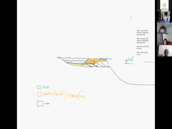
|
| 02:17 | my dad was a doctor and I no interest in medicine at all. |
|
| 02:22 | and at the age of 16 I university undergrad, I finished my high |
|
| 02:28 | , there were only 11 grades in and when we moved from England to |
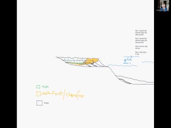
|
| 02:33 | , they put us a year So I was quite young going to |
|
| 02:36 | , I also had a drum set the age of 16. And so |
|
| 02:40 | was kind of torn between my love rock music and my desire to be |
|
| 02:46 | university student. I start off in and physics quite enjoyed those and did |
|
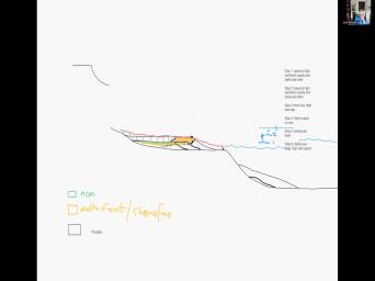
| 02:51 | geology classes just for a lark And two years into it, I |
|
| 02:56 | sort of a declared physics and calculus , but it's still taking quite a |
|
| 03:00 | of geology and two years into my , I switched from the sciences into |
|
| 03:09 | , I did a year of music at the end of that, I |
|
| 03:12 | decided I love music, but it's not for me, you know, |
|
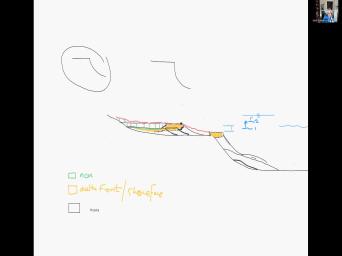
| 03:16 | still maintained my charge as a drummer professionally, but so I said, |
|
| 03:21 | which the scientists that I enjoy the and I thought that geology just seemed |
|
| 03:25 | be the easiest for me was a less work than all that physics and |
|
| 03:30 | . And I sort of determined that could get pretty well a's in geology |
|
| 03:34 | playing and supporting myself as a full musician in a band on the |
|
| 03:40 | So that's what I did. I realized that none of my favorite bands |
|
| 03:45 | the 70s were going to play in . It was too isolated. So |
|
| 03:50 | also at that time, the offshore became a very great focus for exploration |
|
| 03:57 | oil and gas. The discovery of billion a half barrel Hibernia field and |
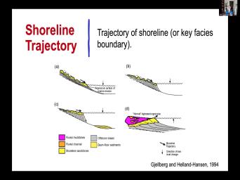
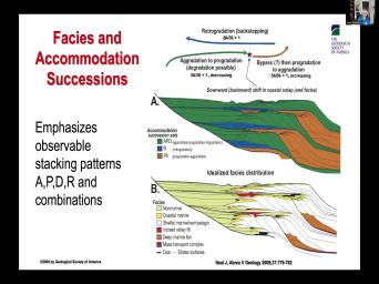
|
| 04:03 | discoveries since then and it turned Newfoundland a have not to have province because |
|
| 04:08 | all the revenue they made from the business. And a lot of the |
|
| 04:12 | companies in Calgary, we're recruiting uh fees to go work at their exploration |
|
| 04:18 | in Calgary. And there was a for me to get out of ST |
|
| 04:21 | and and moved to mainland kata. at the age of 21 I finished |
|
| 04:25 | undergraduate degree, I took a job esso resources Calgary. Um and I |
|
| 04:32 | there about 3.5 years, something like . Um The first thing they did |
|
| 04:38 | trying to make me a geophysicist, forcing us to do a big seismic |
|
| 04:43 | project and I worked on the North basin north of the Hibernia field. |
|
| 04:49 | was kind of hard old two Seismic data and none of it was |
|
| 04:52 | in those days I felt a bit a fish out of water with the |
|
| 04:56 | data. My next project was looking bypassed oil in shallow reservoirs drilling for |
|
| 05:04 | targets in the western Canada basin. that got me into some sort of |
|
| 05:09 | more step out exploration prospect. I much more comfortable with wet logs and |
|
| 05:16 | . Ah I had a couple of stories I drilled I think I drilled |
|
| 05:21 | or 3 wells if I remember and sad stories that the the The 1st |
|
| 05:29 | I drilled was the imperial cheddar And it was in a an oil |
|
| 05:35 | was producing from the cardio formation that below. And there was good good |
|
| 05:41 | of, of oil from the well analysis and a younger sandstone. And |
|
| 05:47 | had a area where I think we About 60, 70% of the |
|
| 05:54 | Um That was my proposed site because well looked, it was fantastic. |
|
| 06:00 | boss decided to change the location to area that I thought looked a bit |
|
| 06:05 | but they kind of wanted to keep and also the well I wanted to |
|
| 06:10 | was one of the best producers in Kardian and so they said well we |
|
| 06:13 | want to mess up the production in lower unit by during your well. |
|
| 06:18 | I thought, well I'm 22 years , my manager knows best. So |
|
| 06:23 | drill the well, we found the that I've mapped, but it was |
|
| 06:26 | anyway. About a year later I the option to to drill another. |
|
| 06:32 | , it was a similar story. again, I just didn't have |
|
| 06:36 | my wits about me. But the while I wanted to drill, |
|
| 06:39 | had an 80-foot sand matt filled with . And but it was only 50% |
|
| 06:45 | a company called Canadian Hunter. My said we can't let Canadian Hunter. |
|
| 06:50 | , we're looking for this bypassed She switched the location to the edge |
|
| 06:54 | my my sand. I said it's and of course the 80 ft santa |
|
| 07:00 | to two 10 ft crevasse plays. again I dropped a dry well, |
|
| 07:05 | left the company, I went to for Canadian Hunter and the l in |
|
| 07:10 | end drove my prospect and found By that time I left the old |
|
| 07:14 | and I was back in grad The lesson I learned was never ever |
|
| 07:18 | a manager take away your prospect from and you gotta fight like crazy for |
|
| 07:22 | ideas. However, you know, better for worse. You know, |
|
| 07:26 | have, I have spent, you , a few million dollars of someone |
|
| 07:29 | money drilling prospects. Um I've certainly my fair share of seismic interpretation. |
|
| 07:35 | Following my three year stint S. resources Calgary. I went back to |
|
| 07:41 | school and did my PhD on some the very first applications of sequence |
|
| 07:47 | which I learned working at esso But when I learned to vest, |
|
| 07:53 | nobody had ever applied sequence photography to logs, it was all, it |
|
| 07:57 | all seismic interpretation. And so I that there was a lot of value |
|
| 08:02 | taking these concepts of seismic photography and to apply that to the correlation of |
|
| 08:08 | long data. I also realized that didn't have a very strong background in |
|
| 08:13 | analysis. I thought the integration of analysis with well logs could really be |
|
| 08:19 | powerful when integrated with this concept of platforms that I learned from my seismic |
|
| 08:26 | . So my PhD was very specifically on trying to developed the methodology for |
|
| 08:33 | sequence photography and subsurface data. At same time, I was doing my |
|
| 08:39 | , john van Wagner and his folks at E. P. R. |
|
| 08:43 | , in the States, I didn't these guys, we're doing exactly the |
|
| 08:46 | project that I was doing on other log data sets that they had access |
|
| 08:51 | . And so at the very end my PhD, they published the first |
|
| 08:54 | papers on sequence photography with examples of logs and outcrops. At the same |
|
| 09:00 | . I was, I was, was finishing my PhD, we came |
|
| 09:03 | very similar conclusions, I had a terminology because their sequence tracked terminology hadn't |
|
| 09:10 | published. And so I was talking alan members and shingles and they were |
|
| 09:14 | about paris sequences and paris sequence sets systems tracks. And and in the |
|
| 09:21 | we sort of converged on a conciliation opinion. In 1989 I finished my |
|
| 09:27 | and moved back to Alberta worked for Alberta Research Council, working on the |
|
| 09:34 | of the, of the atlas of geology of Western Canada. This is |
|
| 09:38 | major project to put together, this the entire story of this incredible sedimentary |
|
| 09:43 | . So once again a very, oil focused project at that time I |
|
| 09:48 | consulting company and topped the very first photography courses by a consultant to my |
|
| 09:54 | anywhere in the world, outside of Exxon group of companies. Because at |
|
| 09:58 | time, sequence string was, was , was confined to Exxon and nowhere |
|
| 10:03 | . So I began teaching sequence particularly . I talked into, I taught |
|
| 10:08 | course to chevron, I think Murphy , a number of other companies. |
|
| 10:14 | . And then, to my After two years of post talking in |
|
| 10:21 | , having this little consultancy, I hired by atlantic Richfield company to work |
|
| 10:27 | their research lab in plano texas. they were trying to build a new |
|
| 10:31 | sequence, particularly research group and they managed to hunt Henry post mentor Henry |
|
| 10:38 | I had worked together in Calgary when was seconded to s. O Resources |
|
| 10:43 | and I was a postdoc and I to know Henry and he and I |
|
| 10:48 | a big chapter on secret street of applications to the western Canada basin in |
|
| 10:53 | atlas that I was working on. and unbeknownst to me, Henry had |
|
| 10:59 | head hunted by atlantic Richfield company. applied completely independently but of course Henry |
|
| 11:04 | me, we're working together and you , to make a long story |
|
| 11:08 | I ended up moving to texas once working with your business and I was |
|
| 11:14 | atlantic Richfield for about five years, much in a in a research |
|
| 11:19 | I worked on major reservoir characterization and photograph applications of the Prudhoe Bay field |
|
| 11:26 | Alaska, The largest oil conventional oil in North America with 24 billion barrels |
|
| 11:32 | oil. And that was very much well log and core project looking for |
|
| 11:37 | pay and and doing a lot of flow modeling that got me heavily into |
|
| 11:42 | characterization. But once again with a on the correlation of well logs in |
|
| 11:47 | field with lots and lots of core , so lots of faces analysis and |
|
| 11:51 | was on shore and seismic data was poor quality. So seismic certainly didn't |
|
| 11:56 | much in the Prudhoe Bay field and following that and I was succumbing to |
|
| 12:01 | for a couple of years that I ended up moving to Plano which was |
|
| 12:06 | home base for the research company and I worked in a variety of projects |
|
| 12:11 | . Ah and I would fly all the world, you know, a |
|
| 12:14 | of my work was looking at I've worked in the south China sea |
|
| 12:19 | , I've done a consultant for BP on their giant fields and the productive |
|
| 12:23 | in the Caspian outside of baku. I've done consulting in the North Sea |
|
| 12:31 | the irish sea china. Um I've a little bit of work in |
|
| 12:38 | working with Ypf ah and uh and done some work in Colombia, working |
|
| 12:43 | Ecopetrol. So I've had a lot global experience consulting for world companies advising |
|
| 12:50 | on their exploration production. I just a big project with Oxy and Houston |
|
| 12:57 | with the Ammann Group on a massive oilfield in Oman, which again, |
|
| 13:03 | of corporate, lots of well logs tightly controlled field, integrating production data |
|
| 13:08 | reservoir characterization. Um So unlike many that you'll meet, I've been in |
|
| 13:16 | trenches like Girl Wells, I have and do a lot of consulting even |
|
| 13:21 | recent with with oil companies. So course, you're going to get a |
|
| 13:24 | of information from someone who actually applies work to oil and gas exploration and |
|
| 13:31 | production. Right, so um so teach with that very much in |
|
| 13:36 | we will cover theory of sequence all the assignments have uploaded on the |
|
| 13:43 | , we should have access to all uh you can start downloading them and |
|
| 13:47 | a look at them. I'm guessing all got some sort of drafting program |
|
| 13:52 | it's just sticking the file in PowerPoint correlating that you can do it on |
|
| 13:57 | if you want to. And obviously week we'll do everything on online and |
|
| 14:03 | next week we'll start meeting in person so that's a bit about myself. |
|
| 14:10 | I said I'm just getting over we'll see how my throat does. |
|
| 14:13 | thought what's called a post viral So I had a bit of little |
|
| 14:17 | to my bronchial tubes and it can a couple of weeks for that to |
|
| 14:22 | . I'm feeling okay right now but do tend to speak loud and I |
|
| 14:26 | a bit worried that you know particularly if I go five or six hours |
|
| 14:30 | be a bit hoarse by the end the day. But we'll take some |
|
| 14:33 | and do some exercises. Uh So a little bit about me. So |
|
| 14:38 | I'd like to do now is for to amuse yourselves. And then each |
|
| 14:41 | you just tell me a bit about you are, who you are, |
|
| 14:46 | you're working, what your interest is the class, what your background |
|
| 14:50 | geophysics, geology and and I just a little conversation. So Angela you're |
|
| 14:56 | the top of my list I guess go angie uh it's Mcdonald's and then |
|
| 15:05 | . Um I was actually born and in Canada. I was born in |
|
| 15:09 | um grew up mostly in Kingston I have worked in the oil and |
|
| 15:16 | industry for almost 20 years now. started at a two D slash then |
|
| 15:21 | bought out by TGS um with well data. So I have a lot |
|
| 15:26 | experience with well log data. I've at Southwestern Energy for eight years |
|
| 15:32 | I'm a geoscience analyst there. Um a geology background. Um My plan |
|
| 15:41 | to become a development geologist once I my Master's. Perfect and you know |
|
| 15:48 | you, so I've had a number students that have done their their thesis |
|
| 15:52 | with me to you know commonly they'll a develop an opportunity with their company |
|
| 15:58 | I've helped them with their well Looking for, you're just evaluating the |
|
| 16:03 | complexity of reservoirs that they're working So um you know if you're interested |
|
| 16:07 | discussing that as we move forward then would be good to Mcdonald's. You're |
|
| 16:12 | next. Yes sir my name is Dennis last name, N. |
|
| 16:19 | So yes sir I was born and in Nigeria. Lagos. Nigeria. |
|
| 16:25 | I got my bachelors in geology at University of Houston. We managed in |
|
| 16:30 | and mathematics. I would love experiencing methods with geology and quietly getting my |
|
| 16:37 | in geophysics. So I plan to my express in geology and geophysics to |
|
| 16:44 | look into or to discover more conventional unconventional oil resources. Yes sir. |
|
| 16:50 | incremental, I'm looking to sacramento cleaning as well. Yeah and I will |
|
| 16:55 | quite a bit of introduction of seismic the class. So you know, |
|
| 17:00 | a bit more from a geological perspective hopefully that will be of value to |
|
| 17:03 | well. And Madonna Hi, I'm . I'm actually from India, I |
|
| 17:13 | my master's strictly last sinister august, got a background of petroleum engineering and |
|
| 17:19 | just developed an interest in the So I just changed my major from |
|
| 17:24 | video scientists. So I'm just looking to get some career in the oil |
|
| 17:28 | gas industry. Very good. And you tie, wouldn't you just |
|
| 17:32 | us some? I know you're not the class but you'll be sitting in |
|
| 17:35 | at all, just tell us tell us what you're doing, who |
|
| 17:38 | working with it at your age. I'm you tie and I currently work |
|
| 17:46 | dr Stewart and my project including use deep learning method to the noise, |
|
| 17:52 | seismic data and also do some web divergent and and reverse time migration |
|
| 18:01 | So. Great, so you're geophysics with rob story. So a good |
|
| 18:06 | of mine. So uh uh and know, commonly the th in this |
|
| 18:13 | particularly they have astrology of physics you know, this is sort of |
|
| 18:16 | good bit of review for them to up some geology. So hopefully um |
|
| 18:21 | , even though you're not taking you'll, you'll still enjoy get something |
|
| 18:25 | of it. Um and you Utah's expertise obviously is not geology. |
|
| 18:31 | role really is to take care of , record the lectures, upload |
|
| 18:36 | Um And obviously when we meet usually some coffee and donuts and stuff, |
|
| 18:41 | All right, so next I'll um you all for that. It's good |
|
| 18:45 | meet everybody and so ah the plan to meet from 1, 2 6 |
|
| 18:54 | time. So that's 2-7 here, 8:35 I think tomorrow if possible Because |
|
| 19:02 | want to get off early. If could start at eight tomorrow, would |
|
| 19:04 | be okay? Okay, that's nine time and then well we probably won't |
|
| 19:10 | , it will probably finish a bit than five, so maybe go from |
|
| 19:15 | , So I do want to, know, it's a bit of a |
|
| 19:18 | to Texas, it's about 2025 So, and obviously for better for |
|
| 19:24 | would be online this week. And next week the plan is to be |
|
| 19:28 | Houston and will uh now you guys taken classes and Fleming right, is |
|
| 19:34 | still freezing? Like it always Yes, very much. Yeah, |
|
| 19:38 | the coldest damn building on campus. I'm looking forward to warm weather but |
|
| 19:43 | like cold encounter in that room Um I want it, I |
|
| 19:49 | I don't have an office so if office hours will be um obviously in |
|
| 19:55 | at our meeting times and you know only three and if you've got questions |
|
| 20:00 | be out and about. I'll probably May or may not be in Houston |
|
| 20:04 | the week but at any rate I'll my phone and I'll have my computer |
|
| 20:11 | so I'll give you all the information cell is there. If you might |
|
| 20:14 | to just stick them. And if got a text and got a question |
|
| 20:17 | an assignment I'll be pretty well available the time. I put my pretty |
|
| 20:21 | all the reading up on the web as you have a student you should |
|
| 20:28 | should have access to university future We have the A. P. |
|
| 20:31 | . Data pages that has um It's the post material book there or should |
|
| 20:37 | took that off? It's got pretty most most of the information is published |
|
| 20:42 | a P. G. Or C. P. M. And |
|
| 20:44 | their publications are available through uhh Okay And I've also given you a |
|
| 20:49 | of my own papers and my own is a lot of them reflect the |
|
| 20:55 | that I will be teaching about. . Um So what are we going |
|
| 21:03 | do? So obviously we want to about the theory of how sequences and |
|
| 21:08 | tracks form as well as the practical for undertaking sequence photographic studies and the |
|
| 21:16 | will be on on well log core outcrop data. There were a lot |
|
| 21:20 | faces analysis and obviously I will spend time talked about size. McDonough, |
|
| 21:31 | give you an overrated a very necessary of the history of photography that may |
|
| 21:37 | you to begin with. But I you'll understand why that's absolutely critical to |
|
| 21:42 | you that background. And I'll give a review of the of the history |
|
| 21:48 | traditional literature photography that dominates the world to the sequence photography practiced by the |
|
| 21:54 | business. I'm going to give you lot of lectures. You're going to |
|
| 21:59 | a lot of exercises, Okay. because it's a small class, we |
|
| 22:02 | interact. We have lots of lots time for questions and discussions as much |
|
| 22:07 | as you desire. Right? It your class and you can direct and |
|
| 22:12 | um the areas that you want to more or less time on as we |
|
| 22:16 | forward. So, so in the slide, I'll show you the topics |
|
| 22:20 | gonna cover and we'll probably get the of them. But we can |
|
| 22:25 | we can expand or contract the focus on how much discussion we have. |
|
| 22:30 | and and conversation versus me talking and doing exercises. So today we're gonna |
|
| 22:39 | gonna focus on a base level concept I'll give you the first exercise. |
|
| 22:46 | will talk about the history of size picture photography. Again, I'll |
|
| 22:53 | some exercises. Uh and then we'll two sequence photography kind of in the |
|
| 22:59 | ? Then almost we'll have a break then the next friday we'll talk about |
|
| 23:04 | methods. Again, you might want have a look at all the, |
|
| 23:07 | of the exercises and have a quick of them. So you kind of |
|
| 23:10 | what's coming. And then we'll have kind of talking about shallow marine sequence |
|
| 23:18 | . Then we'll go to Flavius sequence and then we'll end off in deep |
|
| 23:24 | . My focuses on solicit plastic sequence . Um I am quite interested in |
|
| 23:31 | that I can maybe comment on, know, So there may be some |
|
| 23:35 | lectures that we can do on that week depending on the interest and your |
|
| 23:41 | interests. Okay. Any questions about lecture schedule? Okay. We will |
|
| 23:49 | a quiz on that saturday morning. last saturday we meet usually took 22 |
|
| 23:55 | . But for such a small the quiz will be just not pretty |
|
| 23:58 | . Again, get a feeling from style of exams. So at least |
|
| 24:02 | have one example to go by before final and the final is going to |
|
| 24:06 | up pretty quick. So the final is the Wednesday after our last |
|
| 24:12 | Okay. And in addition to the , all of the exercises will be |
|
| 24:19 | at that same time. So you'll in the exam to don or whoever |
|
| 24:24 | it at the same time that you the final assignments? Okay. And |
|
| 24:29 | you have another class status after I can't, I can't remember. |
|
| 24:31 | this the last one? No, is the last one for the second |
|
| 24:37 | . Okay. Okay. Yeah. , so you know if you feel |
|
| 24:41 | need a little bit more time in exercises, let me know, you |
|
| 24:44 | , we can slip that by a or two. That's not a big |
|
| 24:47 | . I do know there's a deadline get the exams to Don. I |
|
| 24:50 | that's I think he said that's like 17th or 18th and the problem is |
|
| 24:57 | going to have to mail me because moved back in Canada by the time |
|
| 25:04 | by the time you do the so he's going to have to mail |
|
| 25:07 | that stuff to me. Final example worth 50% practical exercises. 40% that |
|
| 25:12 | . 10%. So that's the grading . Hopefully we'll all do great. |
|
| 25:17 | . Any questions about that. Okay, now um let's just start |
|
| 25:54 | ah Angela, could you just draw line and erase a line on this |
|
| 26:00 | board for me? Just see if just make sure it's working for |
|
| 26:12 | Do how do I do it? using my mouth? I think so |
|
| 26:16 | , I think you just click on all participants can edit so you should |
|
| 26:23 | able to draw on it, like can draw a wiggle, see if |
|
| 26:29 | can draw something Mm hmm. I I mean I'm moving my mouth but |
|
| 26:42 | don't see any. Do you see , did you see the options next |
|
| 26:46 | you where it's got a pencil So if I click shape, I |
|
| 26:50 | draw a square. So click on pencil and see if that does something |
|
| 26:55 | you. I don't see a pencil on the left. Because all participants |
|
| 27:10 | edit. Mm hmm Yeah. I see a pencil option. Um Maybe |
|
| 27:27 | the way I have my zoom screen up. You are seeing the white |
|
| 27:32 | though, right? Yes, I see that. And I can see |
|
| 27:34 | squiggles in the square that that you on there. You can't draw on |
|
| 27:44 | . No, anybody else try. . Open and collaborate. Mm |
|
| 28:16 | It says all participants can edit. should be unedited. Not sure why |
|
| 28:25 | . Dennis. Do you want to see if you can draw anything on |
|
| 28:31 | ? I tried sir but I do see the pencil icon and it doesn't |
|
| 28:35 | for me sir. Same with I can't mm hmm. Anything. |
|
| 29:02 | excuse me sir, do we need download them up for that? Could |
|
| 29:05 | see the app icon? We're suggesting can download them up to support the |
|
| 29:14 | if it works. Um Are you are you using the most updated |
|
| 29:26 | It does. It does. Because was this just this just came up |
|
| 29:31 | a day ago when I opened the Zuma I have this option I believe |
|
| 29:37 | have the most updated version because anytime open zone here updates by itself, |
|
| 29:43 | if I opened it today there was updates. So. Okay. But |
|
| 29:49 | you you can't see the white board ? Right. Yes sir, you |
|
| 29:53 | edit, you can't edit it. okay. Do you see a thing |
|
| 30:06 | whiteboard on the bottom of your, says security participants chat, share |
|
| 30:11 | record, live transcript, breakout reactions in white board. Okay. |
|
| 30:19 | be a little icon that says I have a script. I don't |
|
| 30:24 | that. Yeah I think you're using older version. Um Thanks, I'll |
|
| 31:20 | you what we'll do. Why don't take a break for maybe uh 15 |
|
| 31:29 | ? Why don't you all try uploading latest zoom and see if that white |
|
| 31:33 | is there? Because I want to an exercise before we even start |
|
| 31:38 | Um It will really help you understand first lecture. Um There is an |
|
| 31:44 | in the older zoom where you can on, let me try something else |
|
| 31:50 | let me uh we'll try something Ah uh Sorry for interrupt. |
|
| 31:59 | did you select and then no ted , after you collect the white |
|
| 32:09 | clip the white board and it says and collaborate. All participants can |
|
| 32:14 | Yes you can shoot it again and the top there is a view |
|
| 32:22 | Right. Yeah and you click the arrow point downwards and there's a and |
|
| 32:34 | and or ted Yeah, that's not anymore. Um It's not on yours |
|
| 32:44 | because see others say you need to that for others to drill together, |
|
| 32:50 | , You know what he's talking If you go up to the |
|
| 32:52 | you'll see the word annotate, click that and see if you can use |
|
| 32:55 | to draw something. I don't have annotate option either, I don't have |
|
| 33:04 | . Mm hmm. That's why that's that's in the old zoom. |
|
| 33:19 | Usually if I if I click on the very upper he said you are |
|
| 33:24 | you click to the top of you'll see view options and then you'll |
|
| 33:29 | that a little thing that says You don't see that. Mhm |
|
| 33:39 | we can try and I can try update mine. I was able to |
|
| 33:43 | an app, draw and scribbled together to resume but it doesn't look like |
|
| 33:50 | connects to what you have. we can do it this way. |
|
| 34:29 | if I go up I see that . Do you see that now? |
|
| 34:58 | . Okay, would you be able share, if you go up to |
|
| 35:03 | top of your thing? It should . Newt stop video security, participation |
|
| 35:07 | , new share, posher annotate You don't see that. I wonder |
|
| 35:12 | it's because we're not hosts or co because we don't have the recording options |
|
| 35:20 | all that on ours? It just that it's recording. Just give you |
|
| 35:25 | the co host permission. Say I give everybody in the in this |
|
| 35:36 | . Everyone except Mark Dennis as a host. Yes, everyone has a |
|
| 35:43 | . Thank you to share all the the setting meeting now. So you |
|
| 35:51 | the annotate now or? No. . Yeah, I can't forget how |
|
| 36:39 | make this work. Sorry. Works me, but not for you |
|
| 36:53 | I've never used the whiteboard before and you guys can't annotate it it's |
|
| 36:58 | it doesn't work very well. And got because you're not saying Yeah, |
|
| 37:11 | guys aren't seeing the white board. , so we're got stuck, we |
|
| 37:15 | see the white board? Just not way to edit it or drawing |
|
| 37:21 | Yeah, this is using Excellent. do in person. We just sketched |
|
| 37:25 | the whiteboard so it's it is I it's kind of important for us to |
|
| 37:29 | this functionality. I don't know. the best thing is to you know |
|
| 37:44 | that is, is that one of ? Sorry, you're muted, Angela |
|
| 37:54 | hear you, Everybody's muted. I hear anybody. Oh is it? |
|
| 38:06 | you hear me now? Yep? it have a drawing, scribble |
|
| 38:11 | Yeah. With pink lines, Okay, so that seems to |
|
| 38:20 | Okay. Everybody can everybody draw on on their Did you do you have |
|
| 38:27 | McD Ennis? I just I'm sending into the up right now. |
|
| 38:36 | why did you sign up for I'm not sure what we're doing |
|
| 38:40 | Are you able to draw on the ? No, so I just downloaded |
|
| 38:46 | draw and scribbled together whiteboard app within . Okay, so how do I |
|
| 39:01 | that on the online, it's on bottom where it has the participants |
|
| 39:07 | share screen, record, live all of that. There's an apps |
|
| 39:12 | the bottom, right? Yeah, don't see any apps, I just |
|
| 39:17 | the white board. Um Yeah, think it's because I'm using a |
|
| 39:31 | I feel like it's because I'm using newer version of zoom. Okay. |
|
| 39:58 | we should try and see if we download a newer version. Yeah, |
|
| 40:06 | might work. Okay, I'm gonna gonna log out and see if there's |
|
| 40:17 | can update or download a newer Okay. Yeah, like almost a |
|
| 40:22 | let's just reconvene and Let's say 10 and see how people do. |
|
| 40:27 | I do have some other options, can just do a lecture about. |
|
| 40:30 | kind of want I really want to with this exercise. Um I know |
|
| 40:34 | taken a while to get organized but you know, we've we've got |
|
| 40:36 | lot of time, so Mhm. . There you go. I can |
|
| 40:53 | your lines. Perfect. Okay, that's one now waiting for Madonna to |
|
| 41:07 | back and Angela, and if you it, I'm pretty sure it was |
|
| 41:13 | the update. That's all it was ? Hopefully Angie will be back in |
|
| 41:27 | bit And then uh and Madonna said had to do but it would work |
|
| 41:32 | five or 10 minutes so I'm hoping won't be gone for too long. |
|
| 41:37 | hmm Sorry about the slow start today you know this is growing pains I |
|
| 41:46 | . Mm hmm. Yeah. So Mcdonald's has got his up and |
|
| 42:30 | . How about you Angela? I don't have the full, I |
|
| 42:39 | pay for the version for a zoom I looked it looks like that might |
|
| 42:46 | it's a new feature but since I pay for it, how did you |
|
| 42:49 | at Mcdonald's? So if you go the zoom up and you click on |
|
| 42:56 | icon, the icon on your like your picture icon, you show |
|
| 43:01 | for updates, then you click that the update by itself. I do |
|
| 43:05 | pay for. So is that on desktop? Here's what? My deck |
|
| 43:15 | zoom out on my deck stop. , let me try that. Mhm |
|
| 45:35 | you know, I think I'm just get go ahead and start because I |
|
| 45:38 | really want to wait anymore. Um well she'll have to catch up when |
|
| 45:41 | gets here I guess. Okay, first question is what is that? |
|
| 45:55 | guys must might as well just a because I'm well we'll just go back |
|
| 45:58 | forth. What am I drawing The shore line. Okay, anybody |
|
| 46:07 | shoreline for one. Is that a line or is that something bigger than |
|
| 46:14 | ? On bigger slope on the Okay, sloping shelf. Okay, |
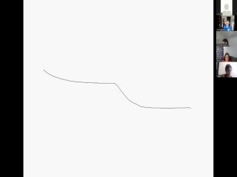
|
| 46:19 | good. Um So that's awesome. the color hair. Okay, let's |
|
| 46:30 | that sea level. Is is that shelf is flooded? Right. So |
|
| 46:35 | going to put sea level right Okay, there is sea level. |
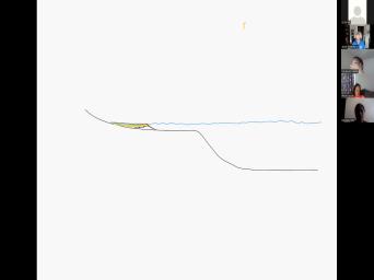
|
| 46:43 | , And then we'll go back to and we're going to draw a wedge |
|
| 46:50 | sediment. So there is our Okay. And we'll just say |
|
| 47:00 | you know, maybe about here um we can well, but that's her |
|
| 47:41 | and then maybe we can just put bit of green in there? And |
|
| 47:46 | will be our non marine phases. . And so this would be sort |
|
| 47:52 | the the area where the sand would roughly correspond to wave base. |
|
| 48:00 | . And I've got this little zigzag . Okay, Okay, now time |
|
| 48:13 | gonna pass. We're going to assume settlement supply. So for step |
|
| 48:58 | we're going to assume hi Selma supply static sea level. Okay. And |
|
| 49:04 | want to propagate that wedge of Okay, so which way is it |
|
| 49:10 | to move? Hi settled supply. got proximate to the left, just |
|
| 49:16 | the right. Which way is it to move? Beijing words towards accommodation |
|
| 49:24 | of the accommodation space. Okay, um would you like to um So |
|
| 49:32 | let's just say, you know, just going to arbitrarily say that, |
|
| 49:36 | know, I'm not giving you how time has passed enough time to the |
|
| 49:40 | land ends up let's say around okay that wedge is gonna move seaward |
|
| 49:46 | that point. So Mcdonald's, would like to draw that new cross |
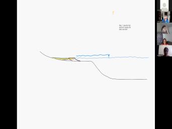
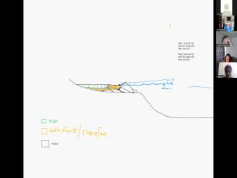
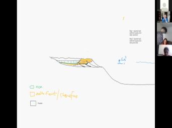
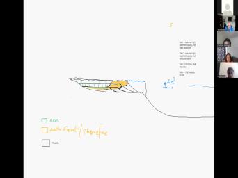
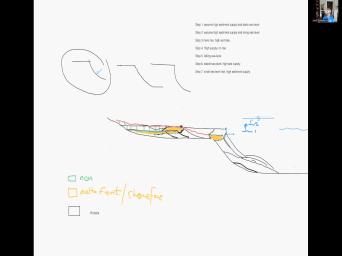
|
| 49:52 | You're going to add a wedge of ? Okay. And um Okay, |
|
| 50:15 | was very good. I'm gonna just the profile. Okay I show that |
|
| 50:21 | concave up. Okay. And then the shows um we want to just |
|
| 50:31 | of keep it going horizontally. Okay then I'll fill in the books. |
|
| 50:49 | did a great job. Just keep geometry the same. Okay now now |
|
| 51:03 | going to change, change things just little bit. Okay now we're gonna |
|
| 51:10 | sea level rise a little bit. , the sea level has moved up |
|
| 51:18 | that point. Okay And I'm going erase the old sea level actually I'll |
|
| 51:30 | it back, Just emphasize that's where was and that's where it is |
|
| 51:34 | Right? So sea level one And Level two. Okay and I'm gonna |
|
| 51:42 | back to black now our new shore we can assume so now we're into |
|
| 52:05 | so step two, I'm gonna assume sediment supply and rising sea level |
|
| 52:29 | Would you like to have a go draw the new wedge? You |
|
| 52:50 | we're gonna help assume high settlement Okay, so good. Start, |
|
| 52:56 | . There we go. Okay. what about your faces? It would |
|
| 53:06 | mostly sand and then a little bit silt on the top. Okay, |
|
| 53:12 | good. Good try. I'll give a point. Let me show you |
|
| 53:18 | I'm gonna do. I'm gonna assume my new shore line ends up |
|
| 53:21 | Okay. And then I'm going to the take the profile that I've drawn |
|
| 53:27 | just and just add it so that's to go all the way back to |
|
| 53:33 | . Um And there's my new See how I keep the drum through |
|
| 53:49 | same con gave up. And then point there that's the shore line that's |
|
| 53:56 | up and let's move seaward of Okay so I'm allowing the system to |
|
| 54:02 | the shore line to continue to Even though sea levels rising, it's |
|
| 54:07 | rising fast enough to flood the flood . So the system keeps up with |
|
| 54:12 | the is able to build out against rise of sea level. Does that |
|
| 54:16 | sense then I'm going to pick. so that's the transition um Yeah. |
|
| 54:35 | a piece for choice of colors? gray. Anyway, never mind. |
|
| 54:45 | So that's that point there are to that's roughly wave based. So above |
|
| 54:52 | mud can settle below that mud can so that that that's the band between |
|
| 54:57 | sandy, you know, delta front shore faces the pro delta. Now |
|
| 55:02 | have another spasm line here. This is the boundary with non marine |
|
| 55:07 | the left and shoreline sand to the . That makes sense. I'm going |
|
| 55:12 | just translate that up a little bit well. Okay. And then I'm |
|
| 55:17 | to fill in the sand and then going to fill in the non |
|
| 55:41 | I'm just gonna use vertical stripes because takes a long time to fill it |
|
| 55:45 | in. Right? So if I going to draw a legend, that's |
|
| 55:53 | marine, that will be delta front your face and then white will be |
|
| 56:29 | delta. Okay, So I just a white box. I'll just say |
|
| 56:37 | from Toronto. Okay. A much legend than the previous one. |
|
| 56:49 | Mhm. Now We're going to go step three and we're gonna rise sea |
|
| 57:02 | again. Whoops, get the right here. So now sea levels gone |
|
| 57:13 | two, 23. Okay and It's your turn. You get to |
|
| 57:23 | the next kind of form and then it all the way back to |
|
| 57:43 | onto the on lap the the landing . And so remember you need to |
|
| 58:17 | this and throw it all the way right. You've got to fill in |
|
| 58:23 | space behind the shore line. Ah I'm going to erase that. |
|
| 58:31 | you go. That's better. I'm going to get rid of that |
|
| 58:36 | sea level. Now let's just let's clean that up a little bit. |
|
| 58:50 | , this is a problem with this . It's tricky and draw my surface |
|
| 58:55 | again that I started with. Okay then you had your new platform doing |
|
| 59:08 | . There is the shoes online and can color and or yellow. Okay |
|
| 59:49 | we well we got we got we our oops. Uh huh. So |
|
| 60:06 | now we're going to continue. Okay you're gonna do this exercise the first |
|
| 60:12 | is the first assignment we're doing right . Okay we're gonna do it as |
|
| 60:16 | group and I'm gonna give you a and kind of explain what we did |
|
| 60:20 | then you've got to actually do the on your own, right? But |
|
| 60:23 | want to do it collectively to try give the idea of how changes in |
|
| 60:28 | level and how the sedimentary area response that. And let me just put |
|
| 60:36 | green in here and Megan. I the way you drew some undulating channels |
|
| 60:45 | if that was deliberate but it looks there's some rivers running across that |
|
| 60:49 | Service the way you've drawn it. . Okay so now mm sea level |
|
| 60:56 | here. So now we're going to step four. What do they say |
|
| 61:23 | I'm gonna learn how to type then got step step four. Once again |
|
| 61:41 | got the river pumping sediment in the but no rise anymore. So we're |
|
| 61:46 | to no sea level rise and high supply. So again I want you |
|
| 61:54 | the next one again. Now what you gonna do? And as much |
|
| 62:02 | you can keep that nice curved geometry the contact form. Right? So |
|
| 62:08 | try make sure you get that geometry , okay, so go ahead and |
|
| 62:15 | draw the next con form. Now no sea level rise anymore. So |
|
| 62:19 | levels now static. But there's still of settlement being supplied into the |
|
| 63:07 | Okay, I'm just gonna clean up little bit. That was a great |
|
| 63:17 | . So that's going to continue. make it black and eventually. So |
|
| 63:28 | the cloud of forms met the shelf . Right? So now the shelf |
|
| 63:32 | now the old slope, the old edge shelf break has now emerged with |
|
| 63:38 | programming delta. Right. And you to draw the salmon for the |
|
| 63:42 | Where is that gonna go? And explain what programs are in another |
|
| 63:59 | But trying to get that concept. we go. Okay, so the |
|
| 64:06 | difference is is I wish it was way to Oh, there we |
|
| 64:18 | So I'm pretty sticky about Sam's little that point in the direction in which |
|
| 64:24 | sound is transiting into the shale. , now Mcdonald's we are now at |
|
| 64:45 | very edge of the system. And the delta is now facing a |
|
| 64:50 | slope. So, do you think gonna happen out in the steep water |
|
| 64:55 | at this time with high sediment I believe most sediments delta front sediments |
|
| 65:06 | be going down the slope. Very . So we might start to get |
|
| 65:12 | little bit of sediment out here. know, you might get some |
|
| 65:21 | you know, coming from the delta being deposited in deep water. |
|
| 65:27 | Because the doubt is not the shelf . Right? And Seattle hasn't |
|
| 65:31 | It's just not rising anymore. Mhm. Yeah. Okay, now |
|
| 65:54 | where it gets complicated. Now we going to drops the level. So |
|
| 66:09 | level was here. Now it's dropped to there. Okay, so Mark |
|
| 66:20 | , you wanna have a go. it your turn now? Is that |
|
| 66:22 | is I'm kind of losing track. should be mine. So, since |
|
| 66:29 | have um the C level jobs, expecting erosion from this shelf. So |
|
| 66:36 | Russia from this shelf, sediments falling freeing up the basement over here. |
|
| 66:41 | . So, can you draw Mm hmm. Okay. Okay. |
|
| 66:52 | was And I believe this is a of pro delta and delta front. |
|
| 67:05 | stones. Yeah, but this is in deep water here now. |
|
| 67:09 | All that stuff there. Right, . So now what about the |
|
| 67:15 | What casino was dropped? Right, the river was here? Now the |
|
| 67:20 | is at that much lower area. ? So, can you can you |
|
| 67:25 | some erosion there? Mm hmm. trying to forget actually, razor. |
|
| 67:34 | you mind if I raised the No, that's great. Yeah. |
|
| 67:41 | , I did so much kind of little bit. And I've seen a |
|
| 67:51 | bit like this trying to like this slope. Okay. You did |
|
| 68:11 | Really good. Couldn't be better. , uh, obviously that the new |
|
| 68:18 | is going to be here somewhere. ? Yes. So there is the |
|
| 68:23 | of surface. The river is still to flow downhill, Right. And |
|
| 68:30 | I'm just going to erase everything above erosion surface there. Okay. That's |
|
| 68:39 | . Okay. Um, I don't remember. You know, I had |
|
| 68:45 | bit of a common form here. . There we go. So that's |
|
| 68:53 | erosion of surface. So we've whacked lot of the old Hiestand sediments |
|
| 68:59 | Um mm hmm. Thank you. those settlements eroded and then they |
|
| 69:12 | you're a submarine fan out here. . Okay. Now more time |
|
| 69:25 | Someone supply is still high. we've now we've eroded and deposited submarine |
|
| 69:34 | . Mm hmm. What we're doing we're actually building a sequence. |
|
| 69:59 | So if you build it step by , I think you really understand how |
|
| 70:02 | works. And then when I just you the static example, you're |
|
| 70:05 | well, I built a sequence. know how it works. So now |
|
| 70:09 | got a stable sea level. Wait minute. So Mcdonald's did the hard |
|
| 70:29 | following sea level. Now we've got six, stable sea level. Steel |
|
| 70:38 | still, oh, this sounds way here And once again, we're going |
|
| 70:41 | build a new plant a farm. the cloud of farm is gonna build |
|
| 70:44 | over the over the the continental upper slope. So Andrew. Do you |
|
| 70:51 | to draw that new client for Remember as much as you can to |
|
| 70:58 | to make it look that nice concave with a flat top. So take |
|
| 71:04 | geometry and stick it down below, at that you see at that low |
|
| 71:10 | level is the red part. That's erosion of surface, but levels still |
|
| 71:37 | that. Right, well, see was right at the end of the |
|
| 71:41 | erosion. Right, right. I want you to draw that |
|
| 71:48 | I'm not seeing I'm not saying that and what you just drew. So |
|
| 71:54 | what do you want? A new complex? And the top must be |
|
| 71:57 | sea level. Right, That's below level. There we go. So |
|
| 72:11 | flatline at sea level. And then current down. That's a bit |
|
| 72:17 | It's just hard to draw out the . Ok, I'm practiced at |
|
| 72:21 | Okay. Uh So I'll help you here. You did good. Um |
|
| 72:29 | we're going to draw a new wedge then there's there is the slow and |
|
| 72:37 | probably going to have some phantom policies here too. Right? And there's |
|
| 72:40 | to be new shoes online. It's to be lower. Okay. And |
|
| 72:46 | going to fill that with concerned. so you see this new delta shore |
|
| 72:58 | is now sitting lower in the photography it's on lapping the old pro delta |
|
| 73:03 | the previous high stands. That makes . Uh huh. Okay. Now |
|
| 73:10 | going to go to the next step cl was rising so sea level fell |
|
| 73:19 | that point and now we're going to allow sea level to rise up a |
|
| 73:24 | bit. Right? We haven't changed by there's still plenty of settlement in |
|
| 73:57 | system but now we're going to rise level. So once again we gotta |
|
| 74:01 | your turn, see if you can that same wage that I've got circled |
|
| 74:07 | there and draw a new wedge. going to Pro Great so that the |
|
| 74:12 | is still going to build C. but it's going to lift up a |
|
| 74:15 | bit. Mm So that helps just that the strong line goes from here |
|
| 75:01 | then let's just assume the neutral line going to be up there. |
|
| 75:06 | so once you got your point, the point and then you just draw |
|
| 75:11 | a flat line that on laps all way back landward and then a new |
|
| 75:16 | climb a phone There you go and draw the front of it so that |
|
| 75:24 | part of the curve there there you . Very good. And then where |
|
| 75:28 | that contact between sand and shale are to go So that that that faces |
|
| 75:36 | right there. Okay. Alright, good. Now I'm gonna just clean |
|
| 75:44 | up just a little bit. You Good damn. But I'm very practiced |
|
| 75:52 | drawing these things as you guys probably . So I I draw my line |
|
| 75:56 | , that's the on lap limit. then I draw my new platform. |
|
| 76:03 | . And there could be some more faces and then my she's online is |
|
| 76:08 | to go way up there. That's going to lift up, Here's |
|
| 76:23 | sand. I'm glad we got this board working. And now I've got |
|
| 76:36 | more non marine feces. Right? that's sitting on old pro delta shale |
|
| 76:44 | an old erosion surface. Okay, . Now, for the first time |
|
| 77:20 | gonna rise sea level again. I'm gonna raise some of these things |
|
| 77:28 | these are old sea levels that we're worrying about anymore. Mhm. So |
|
| 77:42 | we're going to rise sea level. rise it up to here. Up |
|
| 78:00 | here. Now supply drops. So now the short line, it's |
|
| 78:08 | to end up, some are So whose turn is it now? |
|
| 78:13 | think we're back to McDonagh this. now you're gonna have a big back |
|
| 78:19 | , Okay? Okay, so from , cheers perfect. You want to |
|
| 78:31 | your salmon there? Perfect. I'm just gonna, you did it |
|
| 78:43 | well, what a couple of extra are, I'll just do a slightly |
|
| 78:49 | if you don't mind whoops with a round number. There you go, |
|
| 79:21 | hmm. Okay, mm hmm. now we're going to Now we're going |
|
| 79:36 | rise sea level again and again, settlement supply. We're running out of |
|
| 79:46 | land surface there. So let me keep that going a little bit next |
|
| 79:50 | the mountain chains, right? There a mountain chain there. Now we're |
|
| 79:54 | , we're gonna flood it back a bit more. And Angela, do |
|
| 79:58 | want to draw another clot to form there A Bit More Languages? The |
|
| 80:04 | one. Okay. But I've still very low settlement supply. Right? |
|
| 80:22 | I would back step it just a more. So just take that whole |
|
| 80:34 | and just step it back one Mhm. In front. There you |
|
| 80:50 | . Perfect. Okay, so I'm gonna clean it up just a little |
|
| 81:01 | and maybe just exaggerate the thickness just we can see it a bit |
|
| 81:05 | Did great. So we draw another a farm there and it's just not |
|
| 81:09 | back there, just for fun. , now I'm just going to start |
|
| 81:37 | over again. Whoops, mm So sea level is I can |
|
| 82:12 | Okay, so now we're going to let's see another rise a little bit |
|
| 82:19 | here. Up to stay here. . And uh okay, so now |
|
| 83:11 | kind of back to where we started , which is you've already done, |
|
| 83:14 | ? So now we're gonna re increase settlement supply and let that let that |
|
| 83:19 | start to pro grade again. So . Do you want to try your |
|
| 83:23 | at putting a nice eh, renewal the procreation of this system? Mm |
|
| 83:32 | . Yeah. Okay. But now sediment supply is increasing. So let's |
|
| 83:41 | let it build a bit more seaweed that. That's a great plan to |
|
| 83:45 | you drew. Just erase that one make it make it wider. So |
|
| 83:50 | more area. Okay. But we we have that platform to extend past |
|
| 84:03 | previous one. So it's an Have your shoreline maybe here. |
|
| 84:11 | That's your previous shore line. Said New one. Go there. |
|
| 84:17 | And you just take that basic shape the clot to form. There you |
|
| 84:28 | . Okay. Make sure that you sediment in this space here. |
|
| 84:45 | Right. So this is this this has to extend and down lap at |
|
| 84:48 | point. Right? There you I'm just gonna get rid of that |
|
| 84:58 | and than our shoes um starts to again. Okay. Thanks. And |
|
| 85:06 | going to start to get back to green. Put some sand in |
|
| 85:27 | Okay. And then, you we can keep going with this and |
|
| 85:50 | on and so forth. Right. think you guys have the gist of |
|
| 86:01 | . So that's just going to stand there. Sure. Mhm. There's |
|
| 86:28 | couple things we can do. Um can sort of look at how so |
|
| 86:39 | that's the rollover point. Okay, speaking with Sharon. Okay. And |
|
| 86:45 | one way we can analyze the strategic . We've drawn to sort of draw |
|
| 86:51 | trajectory of the shore line through Okay, so this this unit here |
|
| 86:58 | a geometry that looks like that. , so it's it's got an aggregation |
|
| 87:03 | component which means the shorelines lifting It's got a probe rotational component, |
|
| 87:09 | means it's also moving forward. So call that shoreline trajectory ap okay here |
|
| 87:22 | moving in that direction. So it's stronger P. At the beginning and |
|
| 87:28 | more A. So we call it . This was also P. And |
|
| 87:35 | A. And of course here going this one to that one, that's |
|
| 87:42 | that's retro gradation. The shoreline is a retro grading landward. Okay. |
|
| 87:52 | . Now we began with a bunch sediments if you remember, start off |
|
| 88:00 | in this direction. And they built with that. Right, so that's |
|
| 88:07 | P. To A. Okay. then they went horizontal. Then we |
|
| 88:17 | a big shot, a big a of sea level. So that sort |
|
| 88:21 | went p. 8 to p. the shoreline went from here down |
|
| 88:32 | Okay. That this degradation, the I was dropping. Okay. And |
|
| 88:46 | the transition from p. a. . two d. We cut that |
|
| 88:53 | surface. That's called the sequence Okay. The sequence boundary separates the |
|
| 89:04 | stand systems tracked from the following Too low stand systems tracked. Then |
|
| 89:35 | see this big back step here. . We've got this ah surface here |
|
| 89:43 | there's a blue surface and that's the the first big transgressive surface. So |
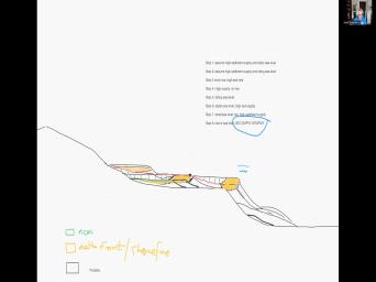
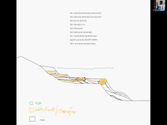
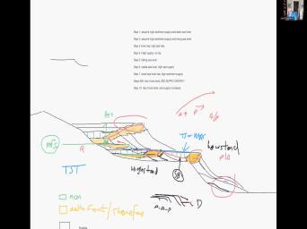
|
| 89:56 | that's called the transgressive surface. The name it's given is the maximum regressive |
|
| 90:05 | . Because you'll notice that that's the the most seaward position on the cross |
|
| 90:10 | with shoreline sediments. There's nothing more than that. So that so that |
|
| 90:15 | in the strategic graffiti marks the maximum , the regression of the shore line |
|
| 90:21 | the surface and immediately above that the faces are everywhere deeper water. |
|
| 90:26 | it's the first big transgressive surface. we get back stepping or retro traditional |
|
| 90:35 | here at that point right there, point right there is the maximum landward |
|
| 90:46 | of transgression, the maximum flooding. that's the maximum flooding surface there. |
|
| 90:53 | top of that wedge, you'll see the maximum flooding surface coincides with the |
|
| 90:59 | surface. And sometimes coincide with the boundary. So here you've got three |
|
| 91:04 | all stacked on top of each other are the maximum flooding surface and the |
|
| 91:10 | surface coincide with the sequence boundaries lower . Okay. And the and so |
|
| 91:19 | green surface there is the maximum flooding . Okay. And the maximum flooding |
|
| 91:31 | surface separates this little wedge in Okay. And that wedge is called |
|
| 91:37 | transgressive systems tracked. And the convention to use a blue color for |
|
| 91:43 | Transgress their systems track. And then over land by the next we'll use |
|
| 91:50 | . The next Hiestand Systems track, is all this stuff here and I |
|
| 92:03 | or not. We've gone, we've through all the sequence photography. We |
|
| 92:09 | a bunch of wedges of settlement from based on some very simple assumptions about |
|
| 92:15 | Supply and Sea Level Change. We've this photography. We had an irrational |
|
| 92:21 | in there. We call that the boundary above that. We had a |
|
| 92:25 | wave of settlement and that wedge sits in the basin. So that's the |
|
| 92:29 | sound. Okay? We use red low stand. So that's the low |
|
| 92:35 | body, including the low stand fans here. Okay, then there's a |
|
| 92:39 | back step for retro gradation in this section. A relatively thin transgressive systems |
|
| 92:47 | and then we start to build the high stand, of course, eventually |
|
| 92:51 | level fall and a lot of the will be eroded away. So not |
|
| 92:55 | of the high stand will be So I've introduced a couple of |
|
| 93:02 | One is that changes in sediment supply sea level or more generally, accommodations |
|
| 93:09 | available percent of in filling controls physically the sediments are deposited in a cross |
|
| 93:17 | . I've highlighted the yellowish orange Sometimes sand is way out in the |
|
| 93:22 | . Sometimes it's way up on the and of course the position of the |
|
| 93:27 | is critical to determine the system's tracks sequences when we had suitable falls and |
|
| 93:32 | . We cut the sequence boundary and when sea levels stabilized at a low |
|
| 93:37 | that based on we deposited the low systems tracked that, that eroded into |
|
| 93:43 | overlying older Hiestand systems tracked a lot which got eroded away during the |
|
| 93:49 | And when the sea level flooded we've got a little thin transgressive systems |
|
| 93:54 | up to the point of maximum transgression with that maximum flooding surface. Comedy |
|
| 94:00 | condensed sections there which make with source and then the system builds back out |
|
| 94:06 | . So anytime you got a consensus , you might have, you might |
|
| 94:08 | a source rock. That shell can cap sand stones. So here you've |
|
| 94:16 | a ceiling faces overlying a reservoir So you're starting to generate reservoir ceo |
|
| 94:24 | and all that is being controlled by in in accommodation and sediment supply. |
|
| 94:28 | when I say accommodation, that means level changes and and the integration of |
|
| 94:34 | . Okay, questions sir. So the pro delta in the transgressive |
|
| 94:42 | or below the transgressive surface and the There are potential source rocks, |
|
| 94:48 | Yeah, the slower the deposit, better. Right, Okay. Any |
|
| 95:04 | questions? Okay, mm hmm. you like a little break before we |
|
| 95:13 | the first lecture? Yeah, let's it. It's 3:52. Um, |
|
| 95:21 | did have a lot of break while messed around getting whiteboard up and |
|
| 95:24 | Let's let's start in 10 minutes. , give me a chance to have |
|
| 95:27 | little and then we'll give the first . Okay. You've already learned a |
|
| 95:31 | of sequence photography in the last I believe or not. Right. |
|
| 95:35 | now I'm going to go through the thing with the lecture And we'll see |
|
| 95:39 | it goes. Okay. So we'll you in about 10 minutes. |
|
| 95:44 | Everybody how you doing? Right. I'd like youth, my home |
|
| 95:56 | but the sunsets and floods my So my wife tells me I'm coughing |
|
| 96:02 | lot. So I'm I've got some desperate secretes here that have half |
|
| 96:07 | but hopefully they'll mm hmm. Help me from not being so |
|
| 96:14 | Listen to my coffin all afternoon. . Right. Any questions before we |
|
| 96:22 | on? Mm hmm. Okay. we'll start with the first lecture. |
|
| 97:00 | um this is a little simple Excuse me, Flow is from left |
|
| 97:09 | right. So in that direction we this little reference area here from the |
|
| 97:17 | , a little sediments coming in and sediments coming out. Okay. |
|
| 97:25 | So if more settlement comes out and in, what's happening to the reference |
|
| 97:34 | . Thank you. Most settlements coming . They're going out, then I |
|
| 97:38 | see aggregation or progression. So more is coming out and going in. |
|
| 97:47 | what's happening to the, what's happened the area where the surface. |
|
| 97:53 | Oh, I'm sorry, reversed So much sediments going out and coming |
|
| 97:57 | . So the reference air will be sediments. Exactly. Increasing division. |
|
| 98:04 | , Exactly. Right, degrading. likewise, if we had more settlement |
|
| 98:08 | in, unless someone coming out than area is a grading, right, |
|
| 98:17 | upward depositing. The question is, know, fundamentally what controls whether we |
|
| 98:22 | erosion or deposition. That's what we're the last exercise. Sometimes we're depositing |
|
| 98:28 | sometimes we are eroding and shifting sediment one place to the other because it |
|
| 98:33 | being eroded. So, you along a given profile, we've got |
|
| 98:40 | settlement discharge. Okay, So here sentiment discharged in area one is |
|
| 98:51 | Right? So the rate of sediment with time will be decreasing if I |
|
| 98:57 | going to drawing as a differential And here sediment supply to is increasing |
|
| 99:05 | time. So D. Q. DT would be increasing. And we |
|
| 99:11 | that in terms of elevation of the and other differential equations. What controls |
|
| 99:19 | or not we get sedimentation or erosion the bed. A lot of that |
|
| 99:24 | controlled by changes in slope because changes slope, change the bed share |
|
| 99:30 | General erosion is favored by increasing deposition is favored by decreasing slopes. |
|
| 99:39 | here we've got your standard ripple or bed forms. Right? So, |
|
| 99:43 | know that on the floors of rivers get smaller scale ripples and they grow |
|
| 99:49 | larger scale dunes and sometimes the ripples climb on the back of the |
|
| 99:54 | Making cross bedding. Okay, you have heard that your sentiment ology |
|
| 99:59 | but the way this works is that , on the back of the, |
|
| 100:03 | the bed form, we've got erosion sand and that's been a positive in |
|
| 100:08 | front of the sand. We have , so we have an erosion regime |
|
| 100:13 | that's where the water depth is And by the Bernoulli principle, if |
|
| 100:17 | do increase the water depth, you've to increase the velocity to to conserve |
|
| 100:22 | volume of water moving past scenario. course, the shear stress, Tanaka |
|
| 100:30 | related to the erosion. Is it to velocity? You and this area |
|
| 100:35 | the water, the water is the pressure increases, the shear stress |
|
| 100:41 | and you get deposition in that lower stress area. Thanks, that that |
|
| 100:47 | course occurs as a result of the defamation of the flow that produces ripples |
|
| 100:54 | dunes and that relates to band related . If you want too much, |
|
| 100:58 | worry too much about in this really more of a semi mythological problem |
|
| 101:05 | , just imagine a river that's flowing . Okay, so it's flowing in |
|
| 101:09 | direction right now, we've got if just imagine the earth is a |
|
| 101:17 | okay, and if we put a on that, okay, the pressure |
|
| 101:23 | is going to be directed towards, the gravitational forces is directed towards the |
|
| 101:29 | of the earth. Okay, and you've got if we've got water flowing |
|
| 101:36 | , which is this diagram here. , we have the red force, |
|
| 101:43 | , we had the green, the force that's directed towards the center of |
|
| 101:47 | earth. Okay. And that can resolved into the pressure force that's perpendicular |
|
| 101:55 | the slope and assuring force that's parallel the slope. So the red area |
|
| 102:00 | the resolution of the gravitational force that's the water to the center of the |
|
| 102:05 | into a pressure force that's perpendicular to surface and assuring force that's parallel to |
|
| 102:10 | surface. The pressure is basically the density of the fluid times the gravitational |
|
| 102:17 | times the height. So that's that arrow and the shear stress is the |
|
| 102:24 | density of the fluid in terms of constant times the height. So basically |
|
| 102:29 | pressure slash gravity force multiplied by the of that very long angle. And |
|
| 102:35 | will give you the white arrow. if you look at that equation, |
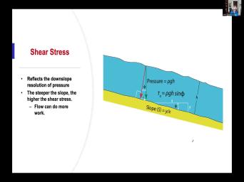
|
| 102:41 | happens if the slope increases? So slope is this, you increase |
|
| 102:49 | slope to that, increase the What happens to the white arrow? |
|
| 103:08 | I can't see your lips moving and can't hear you. Sorry, I |
|
| 103:13 | talking to my son. Okay, if you increase, increase the |
|
| 103:21 | I believe the white owl gets larger and that means the surest dresses more |
|
| 103:29 | ? More share stress. You can larger grains, you can erode more |
|
| 103:34 | . Right? So you increase the of of the ability to move larger |
|
| 103:38 | . And that generally results in So the flow is able to do |
|
| 103:42 | work as the slope increases. the higher the shear stress, which |
|
| 103:48 | the white arrow. Very good Mcginnis. So interestingly when water is |
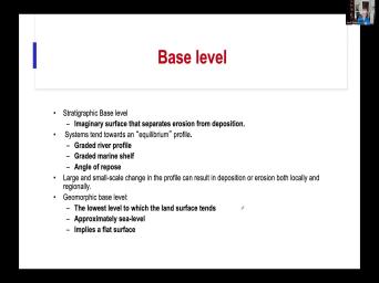
|
| 103:58 | downhill downhill in a river right? velocity increases away from the the rough |
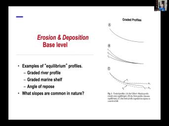
|
| 104:05 | . Okay. And of course the stresses greatest the shear stress. Uh |
|
| 104:10 | equation for sure stress is the rate change the fluid times the position versus |
|
| 104:21 | position. The fluid that would be right. The rate of change of |
|
| 104:26 | velocity versus position to flow. But pretty clear that velocity is increasing rapidly |
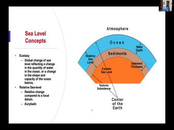
|
| 104:31 | part of the flow and it's more in that part of the flow. |
|
| 104:36 | do you by Dy is decreasing, should go up and that's reflected in |
|
| 104:40 | decrease in share stress. So the share stress is in the area where |
|
| 104:46 | velocity builds up rapidly from the no at the base. Okay. That's |
|
| 104:51 | all the works are being done at base and the sides of the river |
|
| 104:57 | makes sense. Now we get to idea of base level base levels a |
|
| 105:05 | about it should be an easy concept it's it's unfortunately like many things in |
|
| 105:11 | used in different ways by different So from a geographic perspective, you |
|
| 105:21 | , you've got land and you have sea, you know, people often |
|
| 105:34 | that the land degrades down to sea or lake level if you're in a |
|
| 105:40 | . right? So the idea there that sea level is kind of the |
|
| 105:45 | that separates erosion from deposition and it's and relatively horizontal. That's kind of |
|
| 105:52 | , the ge amorphous concept to be base level. You know, the |
|
| 105:57 | level means flat and it means, know, a flat or level surface |
|
| 106:02 | at the base of something. we also have this concept of |
|
| 106:08 | graphic based level, bit more subtle . It's it's it's an imaginary |
|
| 106:14 | So a potential metric surface that separates from deposition. And if we go |
|
| 106:21 | to this example here, you there's erosion here and deposition here. |
|
| 106:27 | based on it would be an undulating at the instantaneous level that separates the |
|
| 106:33 | from of erosion from the area of . In the large example, |
|
| 106:39 | you know, there's some equilibrium between forces that drive the water downhill. |
|
| 106:44 | resisting forces that resist sediment transport and river at some point will achieve an |
|
| 106:51 | where the river is neither doing work the sentiment stable. If you increase |
|
| 106:55 | discharge, then the water will have water and it may begin to erode |
|
| 107:01 | , but once it once it erodes threshold of material, it will reach |
|
| 107:07 | new and different equilibrium. So equilibrium could include what's called a graded river |
|
| 107:16 | . So, a surface of, know, in which the forces of |
|
| 107:21 | water down the slope are are matched the frictional forces that that limit the |
|
| 107:28 | of the water. People talk about grated marine shelf and if we go |
|
| 107:35 | to my bed for my idea, at the end, if you start |
|
| 107:39 | sand grains on a surface and building a pile, okay, the pile |
|
| 107:46 | sand will build up to a threshold at some point if you put more |
|
| 107:50 | on the pile, then the grains start to flow down the size of |
|
| 107:54 | hill. Okay, so that angle called the angle of repose, the |
|
| 107:59 | of rest of sand grains on the . That angle proposed, it's |
|
| 108:07 | what do I say here? Um angular pose, I think that's about |
|
| 108:14 | the 35°. It's a bit different for sand versus dry, dry sand. |
|
| 108:19 | river might have a slope of the -1, 2, 10, |
|
| 108:27 | -5 Supreme Slopes for Rivers. And of course the continental shelf might |
|
| 108:36 | a slope around here. Anyone know the slope of the continental slope |
|
| 108:41 | What is the actual continental slope? that number? That's what we started |
|
| 108:47 | right shelf slope. What is, is that actual slope? S |
|
| 108:55 | anyone know? McManus, you must this sediment sediment ology 101 About 1-4°. |
|
| 109:10 | , that's a pretty steep, steep in nature. Okay, we'll come |
|
| 109:13 | to that too. So we've got , this concept of base level and |
|
| 109:19 | two different concepts. One is, sort of, you know, it's |
|
| 109:23 | sort of water level, you with sedimentation blow and its propensity for |
|
| 109:30 | erosion above that or it's the actual profile itself. And there are different |
|
| 109:35 | , Okay, they might be related each other, they're not quite the |
|
| 109:39 | thing. They it's easy for students get them confused. So in that |
|
| 109:43 | , I don't like the concept of , graphic base level a much apart |
|
| 109:48 | to refer to it as an equilibrium , equilibrium profile can be a dipping |
|
| 109:55 | , but the word base level means that's at the bottom base and something |
|
| 110:00 | flat. An equilibrium profile is not . So using the word base level |
|
| 110:05 | describe an equally profile is a perversion the english language in my humble opinion |
|
| 110:12 | should be abandoned. I don't think gonna win that battle, but |
|
| 110:15 | I just find it confusing. The other thing we need to talk |
|
| 110:19 | is the idea of sea level. so there's this concept of use static |
|
| 110:25 | global sea level. UCC just means . So you say global sea |
|
| 110:31 | you static sea level and there's two you can change the volumes of the |
|
| 110:37 | basins. One is to take water of the oceans and stick it on |
|
| 110:41 | as glaciers and ice sheets. And called glacier used to see and we'll |
|
| 110:49 | about that a little bit. The way is to actually change the volume |
|
| 111:00 | size of the ocean basins at ocean are areas where you've got oceanic biosphere |
|
| 111:08 | sinks into the mantle. The younger ocean atmosphere, the harder it is |
|
| 111:13 | the more it elevated, forming oceanic and these mid oceanic ridges can be |
|
| 111:19 | shallow indeed in places like Iceland, pop above water. And at times |
|
| 111:25 | earth history where there's a lot of ocean crust, the volumes of the |
|
| 111:29 | basins are smaller and that water is onto the continents. So we refer |
|
| 111:35 | that as tectonic. I used to the tectonic used to see our global |
|
| 111:48 | and the size of the ocean basins by the tectonics of of oceanic lifts |
|
| 111:55 | spreading. Glacier used to seeing refers the to the threat to the to |
|
| 112:01 | precipitation of water on land as ice remove it from the oceans. That |
|
| 112:06 | lowers the water debts. And the usually operates at frequencies of tens of |
|
| 112:13 | to a few 100,000 years. Tectonic to see occurs at frequencies of millions |
|
| 112:18 | billions of years. Okay, in our example, we we had |
|
| 112:26 | surface Okay, and we had sea going up and down. Okay. |
|
| 112:34 | you know, if sea levels you know, and we we build |
|
| 112:39 | in. Okay, clearly you're you're sea level with sediments. So that's |
|
| 112:44 | example of a relative sea level So maybe there was 20 m of |
|
| 112:48 | here. Now there's no water because settlement filled it in. So at |
|
| 112:52 | point you gotta showering, but it's only relative to that point. There's |
|
| 112:58 | absolute change in the actual heights of level. You have relative relative decreasing |
|
| 113:08 | . C. At that point because area filled up with sediment. Thanks |
|
| 113:15 | you can have a little rift basin drops down and so you might have |
|
| 113:19 | area, we've got local subsidence that to cause an increase in sea |
|
| 113:24 | even if the water surface is relatively . So relative sea level refers to |
|
| 113:29 | changes uh compared to a local as opposed to a global data. |
|
| 113:36 | Bill Hawk, who is one of godfathers, have you start at sea |
|
| 113:41 | back in the days he worked, has coined this term, You're aerobatic |
|
| 113:45 | level to refer to relative sea level opposed to use static sea level to |
|
| 113:49 | global. So, natural slopes, know, slopes are variable. The |
|
| 113:57 | proposed, which again, is that heights that you can build up a |
|
| 114:01 | of sand About 32°. You know, you've got a river that's, you |
|
| 114:09 | , little meander river here, block of river, you got some point |
|
| 114:25 | , you know, as, as , As the river migrates, it |
|
| 114:31 | these lateral accretion surfaces, those can about 15°. The continental slope itself 3-4° |
|
| 114:40 | is about less than .1 degree. that's a gradient of about two m |
|
| 114:44 | kilometer. We've got 20.0 and two slope. The Mississippi River flows over |
|
| 114:50 | of .002° or five times 10 : . The Ramos, which drains drains |
|
| 114:58 | Germany into the Netherlands, is an management steeper but still pretty slow. |
|
| 115:05 | Most big rivers flow over fractional slopes less than 11° and commonly too difficult |
|
| 115:12 | measure grenades and system. Just Y. I. So here are |
|
| 115:17 | zones of the city for a So the continental slope is about .1°. |
|
| 115:22 | the continental shelf about .1° the continental , 1 to 4 degrees the continental |
|
| 115:29 | . And of course the abyssal plains and flatter. No, we started |
|
| 115:37 | this afternoon by drawing a profile. guess I drew the profile lower down |
|
| 115:43 | profile here, you know, that's very typical profile, about a greater |
|
| 115:48 | might have. Okay. Um And over time you might lower the |
|
| 115:58 | say, by erosion or if you've mountains, you might lift it |
|
| 116:03 | Of course, if you lift it and the river is bound to that |
|
| 116:07 | , if the land lifts up, the river will tend to erode back |
|
| 116:12 | to the level that's comfortable at, reach back to its equilibrium profile. |
|
| 116:18 | , if that profile gets eroded, know, the erosion will get less |
|
| 116:21 | less and less until the river simply have the shear stress to erode |
|
| 116:28 | And then the scenario that we talked this afternoon at time, one we've |
|
| 116:32 | a river greater to that point. , you know, it's flowing down |
|
| 116:35 | slope that's getting gradually less, then drop sea level when we expose this |
|
| 116:41 | here with a sudden increase in Okay, now, I'm a runner |
|
| 116:47 | a cyclist. So let's just say you're going along the flat and then |
|
| 116:53 | see a low area, what's going happen to your bike? What's going |
|
| 117:03 | happen to your bike when you hit slopes? Your speed increases? |
|
| 117:13 | And if you're water, you're going speed up. Right, of |
|
| 117:16 | that's why when you get exposure of increase in slope, rivers speed up |
|
| 117:23 | they will erode back down to a equilibrium profile that's lower than the area |
|
| 117:30 | the river was greater to when sea was higher. Right. Oops. |
|
| 117:44 | . So, this is a pretty problem. So, we've got three |
|
| 117:50 | level scenarios here in scenario one, got a drop of sea level and |
|
| 117:59 | , you know, the river is to that point. Now, the |
|
| 118:03 | exposes this point at which there is increase in slope and of course, |
|
| 118:08 | soon as the river starts to flow the steeper slope, it speeds up |
|
| 118:12 | it will have a tendency to erode above the red line and McX Dennis |
|
| 118:18 | was the red sequence family that we in the exercise. And of course |
|
| 118:24 | have. The question is, how is the erosion will play everything off |
|
| 118:28 | , you know, will it leave ? They're high and low, |
|
| 118:32 | Because, you know, in plan , you know, if you look |
|
| 118:38 | on top of the scenario, there a river, okay? And if |
|
| 118:42 | level falls from this level to that , you know, the river will |
|
| 118:47 | here, what's called the next So the area will be rode |
|
| 118:51 | But if there's no river to road area, then that area might behind |
|
| 118:56 | . There's no process to erode That's why the sequence boundaries commonly have |
|
| 119:00 | undulating geometry to them. Now, scenario two, we have a |
|
| 119:10 | That's great. At that point we sea level, but there's no change |
|
| 119:13 | the slope that's exposed. So in case the rivers neither going to a |
|
| 119:20 | or we wrote was in case the steepest slope is exposed, so |
|
| 119:25 | the river will degrade, degrade. in scenario three, we still drop |
|
| 119:36 | level, but the river was exposed this point. Over and now, |
|
| 119:43 | the new sea level, we're exposing lower slopes. Right? And so |
|
| 119:47 | you're a cyclist, Okay? And going down the hill and then the |
|
| 119:54 | , the ground flattens off. What to your speed when the ground level |
|
| 119:59 | to get flattered, it will slow and the river will do the |
|
| 120:06 | it will lose its its its competence move sediment and it will begin to |
|
| 120:11 | . And I've shown deposition of a alluvial wedge with the orange wedge there |
|
| 120:17 | theoretically it could it could build back to that dash line, right, |
|
| 120:21 | on what happens that surface. Eventually alluvial opponents will on lap at some |
|
| 120:28 | landing. Okay. And that's in in our diet and our exercise. |
|
| 120:34 | , as we increased sea level. , we increased the that the geometry |
|
| 120:40 | that prison of sediment producing on Okay, so that's that's how it |
|
| 120:47 | because of the slope changes does that sense? There is kind of a |
|
| 120:58 | dimensional illustration of the concept. So got sea level up here at |
|
| 121:05 | one, that's the double drops. river extends across the now exposed shelf |
|
| 121:14 | soon as the river starts to experience increase in slope, it cuts this |
|
| 121:18 | shaped or diamond shaped uh notch or . Right, So that's the |
|
| 121:26 | Okay, along this line. And also see erosion at these two points |
|
| 121:33 | . Now, in be time interesting. We see that this nick |
|
| 121:38 | has experienced head with erosion, which thick point hasn't grown very much. |
|
| 121:44 | , Why would that be? Why that nick point expand? And this |
|
| 121:48 | stayed relatively stable. You guys have theories as to why you get more |
|
| 121:54 | in this area, less erosion in area. What could cause that the |
|
| 122:01 | of the slope, so higher We see higher velocity and more more |
|
| 122:08 | erosion. Wife. Um global stiffness flatter slopes. We see some less |
|
| 122:18 | . That could be. But now for argument's say that in this case |
|
| 122:22 | slope here is the same as So let's say there's no change in |
|
| 122:26 | between two areas. Why would this erode more in this area? A |
|
| 122:31 | less? Let's say it's not slope . What, what's something another geological |
|
| 122:38 | that controls the ability to erode a . The grain size or compaction. |
|
| 122:46 | , So that's so this could be granite, that could be a recent |
|
| 122:51 | sound. Right, So, so cohesiveness of the strength of the land |
|
| 122:58 | . So maybe this is softer It just it roads more easily even |
|
| 123:02 | there's not a big river there. . Now what's interesting is what that |
|
| 123:09 | is this area is extending and eventually captures the river. See that So |
|
| 123:15 | the big river is flowing in this area and it's left the old |
|
| 123:21 | This area. The approach that the the nick point has expanded so it |
|
| 123:28 | through time, a little bit more a little bit less than middle |
|
| 123:32 | but it's not as much as the era. Now let's just rise sea |
|
| 123:39 | and flooded back. Okay, so we're gonna rise sea level. And |
|
| 123:44 | got three valley systems, Valley one too and valley three. Okay, |
|
| 123:51 | three. Now what is going to the fill of value to when it |
|
| 123:57 | back? I remind you it's got big river. So at the end |
|
| 124:03 | , of, of of the fall sea level, sea level starts rising |
|
| 124:07 | like we did in the exercise, got this big river that's sitting in |
|
| 124:11 | too. So what's valley to going fill with what kind of settlement the |
|
| 124:24 | exactly. It's gonna be, it's be filled with flu real sentence. |
|
| 124:28 | . What about area one and There's no big rivers in those areas |
|
| 124:32 | . What do you think? They with, there's no river and they're |
|
| 124:38 | transgressed. So what kind of sediments to fill those, those valley |
|
| 124:46 | Since we have no river, would there be a lot of flooding |
|
| 124:49 | there? Yeah, flooding and what of sediment find? Green, fine |
|
| 124:54 | sediments, mud stones. Exactly. now, I want to tell you |
|
| 125:01 | story to go back to my experience at atlantic Richfield Company In the last |
|
| 125:10 | or two. Before I left the , we drove some wells at the |
|
| 125:16 | , there was some of the most wells the company had ever drilled, |
|
| 125:19 | about 20 million bucks and they were the black sea offshore Romania. Adoringly |
|
| 125:26 | and, and they would, they playing really, really big in size |
|
| 125:32 | . So this was the play and had an HBO attitude versus offset that |
|
| 125:40 | that these values are always canyon scale demonstrate they had gasoline. So they |
|
| 125:46 | very excited at that gas hose. . And we have valley films and |
|
| 125:53 | course they assume the valleys were filled sand, florida sand and they assumed |
|
| 125:58 | the gas anomaly was, was They drilled in the valleys and they |
|
| 126:05 | into thick morals. The Black Sea sort of restricted lesson, normal celebrity |
|
| 126:13 | and the malls are very, very to custom the muddy sediments that Mcdonald |
|
| 126:18 | would fill the valleys if they filled a river. So the wells |
|
| 126:25 | I was asked to kind of do little bit about analysis of why that |
|
| 126:29 | expensive wells failed or ask the what was your risk? The valleys |
|
| 126:34 | filled with mud versus sand said, aren't all valleys filled with sand. |
|
| 126:38 | like, no read the west Coast , you know, think it |
|
| 126:44 | So you know, I give this because you know this model and just |
|
| 126:49 | about just being able to answer the that that Dennis correctly answered. You |
|
| 126:54 | , some valleys would fill with with deposits because there's a big river in |
|
| 126:58 | . But other valleys, men have river at the end of the |
|
| 127:00 | it may switch somewhere else and therefore valleys may be filled with marine muds |
|
| 127:06 | therefore they have lower exploration prospectively. , the other point that I want |
|
| 127:16 | point out is that when the sentiment coming out of these valleys or nick |
|
| 127:21 | , they flow down the slope, the slope decreases, you get the |
|
| 127:26 | of the submarine fans at the point you get a decrease in slope, |
|
| 127:31 | . And and at every given point would be a choke point and of |
|
| 127:35 | a line of choke points make a on. So this idea of chalk |
|
| 127:40 | , nick point is really critical in where erosion and deposition occurred, |
|
| 127:46 | And you will be asked about that quizzes and exams. It's an important |
|
| 127:50 | . I'd like you to kind of try to get that in your brains |
|
| 127:54 | then this is kind of a key and this one that illustrates the idea |
|
| 127:59 | , of choke points and it okay, they're pretty straightforward concepts. |
|
| 128:07 | point is just a point along a sectional profile where there's a sudden increase |
|
| 128:13 | slope that promotes erosion and a choke is a point along the cross sectional |
|
| 128:19 | where there's a decrease in slow that deposition. So the change in the |
|
| 128:24 | is really critical in controlling definition It all goes back to the size |
|
| 128:30 | that white arrow when the focus, the arrow gets smaller and the flow |
|
| 128:35 | do less work, which means it move as much material. When the |
|
| 128:39 | increases the white arrogance, bigger the is capable of do more work and |
|
| 128:44 | able to erode pretty simple concept. , so here's some examples. |
|
| 128:52 | Henry post mentor is kind of a of mine. He's the only guy |
|
| 128:56 | know this is a photograph he took a puddle on a field trip to |
|
| 129:02 | Alberta And this puddle might be 6, 7 ft across. They |
|
| 129:07 | he's got an oil rig here, know, and this was sort of |
|
| 129:12 | days of sequence photography and Henry look, you know, it doesn't |
|
| 129:15 | whether it's a popular notion, the of, of gradients, profiles and |
|
| 129:22 | the land surface reacts to base level are the same regardless, regardless of |
|
| 129:27 | it's relevant elevation changes of a puddle the wet and dry seasons in Alberta |
|
| 129:33 | sea level changes called by glaciation or . So the puddle used to be |
|
| 129:39 | here, then it found fell again cut this nice lip point and deposited |
|
| 129:47 | delta so the shoreline was here. the shoreline fell again to its new |
|
| 129:55 | . Now we see there's more erosion there is the act of delta. |
|
| 130:03 | evidence of a little bit of waves this puddle. We've got a little |
|
| 130:06 | cut terrace here, so we got erosion. Somebody probably stepped on this |
|
| 130:12 | . So there's a little bit of erosion, but we can see these |
|
| 130:18 | and these are very similar. You , if I just do a cross |
|
| 130:23 | , you know, from a to right, we have the profile that |
|
| 130:28 | started, right. And when the level fell down here, this area |
|
| 130:35 | was eroded because there was a point there's the nick point. Now there |
|
| 130:40 | no big channel here. I saw nick points a very localized feature and |
|
| 130:44 | fumbling sediments to make this nice low fat. Here's a slightly bigger example |
|
| 130:50 | again, Henry Postman Tyra took when was when we were making one of |
|
| 130:54 | flights in the Salt Lake City to look to our great great quotations |
|
| 130:59 | These are the old shorelines of Lake , which was a glacial lake that |
|
| 131:07 | to form the modern salt Lake of , as the lake level fell. |
|
| 131:12 | know, there's an increase in slow point and you see these diamond shaped |
|
| 131:18 | , right? And eventually the stream like it starts to maybe start to |
|
| 131:23 | out of its in size. To point, you can still see the |
|
| 131:28 | channels and size and then at this it looks like the channel starts stuff |
|
| 131:33 | out a little bit. So that's of where these channels are now free |
|
| 131:37 | kind of migrate around a little So that's sort of the last knick |
|
| 131:41 | right there. Now, another interesting recently published by john Hallberg, |
|
| 131:51 | not that recently, a guest and came up this idea of the rivers |
|
| 131:57 | controlled by the point that the river graded to downstream which you referred to |
|
| 132:02 | the buttress and of course the river also has this equilibrium profile. And |
|
| 132:12 | , the equally in profile is never . You know, as you |
|
| 132:16 | rivers most of the time aren't doing much Madonna, you're from India. |
|
| 132:22 | you know about monsoons and you know when you're living in an area with |
|
| 132:27 | , the rivers get very flooded and got relatives that live in Kolkata and |
|
| 132:32 | , you know, the floods in during the monsoon season can be |
|
| 132:35 | pretty catastrophic in the dry season. know, it's hot and people a |
|
| 132:39 | happier. So of course the river up and down depending on whether it's |
|
| 132:45 | lots of water, a little bit water and and how much sediment the |
|
| 132:49 | carries as well as what the land is doing. So, the ability |
|
| 132:55 | the river to erode down which john refers to as the lower buffer profile |
|
| 133:03 | limited by its transport capacity, it's up in flux in the uplift |
|
| 133:09 | Okay, so um if the river completely choked with sediment so it can't |
|
| 133:18 | it can't um sorry if the, the transport capacity is at its |
|
| 133:24 | which means you've got blue water with sediment, that means the river can |
|
| 133:29 | hold a lot more sediment so as as it can hold sediment, it |
|
| 133:33 | continue your road. So what it's the maximum ability to transport sediment i |
|
| 133:39 | it's that low capacity. It's um able to erode again. This may |
|
| 133:46 | controlled by the fact there isn't much . So if there's a lot of |
|
| 133:50 | not much sediment then the water can more sediment inwards. It can erode |
|
| 133:55 | . Okay. And of course you if the if the if the land |
|
| 134:01 | uplifting maximally the rule will be cut . If the upper the upper plate |
|
| 134:06 | minimal then the river already can't cut anymore. So that kind of controls |
|
| 134:10 | lower that lower profile. The upper Is again the same. three |
|
| 134:17 | If the river can't carry sediment anymore so choked with sediment that if more |
|
| 134:24 | is added but then it just it deposits it so the river is lifting |
|
| 134:28 | up. Okay. And so the is bouncing up and down in this |
|
| 134:34 | profile as a function of the amount sediment that's being delivered to the |
|
| 134:39 | The amount of water which controls the capacity and whether the land surface is |
|
| 134:43 | surface lifting up or falling down. . Now we can also sort of |
|
| 134:50 | now the budgets of course is the downstream that the river is is stops |
|
| 134:56 | where the river stops okay. And can shift seaward by delta procreation. |
|
| 135:02 | can be lifted up by sea level or building of dam or it can |
|
| 135:07 | if base level of sea level Okay. So the downstream controls are |
|
| 135:15 | things that just talked about, but controls the upstream part of the economic |
|
| 135:20 | ? Well, that could be related the nature of the source area related |
|
| 135:25 | climate. It's raining or it's not . Not even linkages between the two |
|
| 135:30 | well as, as the basin These interact sometimes in reciprocal ways and |
|
| 135:37 | they work against each other. Mm . I'd like to talk about boundaries |
|
| 135:46 | little bit more. So, you , a key boundary is the shore |
|
| 135:53 | . Okay. That's the point you know, a river meets the |
|
| 135:58 | . Honestly, when, when, the river hits the sea, |
|
| 136:01 | you know, it's, it's, like if you ever dive, you |
|
| 136:05 | , if you ever jump into water soon as you hit the water, |
|
| 136:08 | slow down, right? And as as the river hits a standing |
|
| 136:10 | it slows down now. Um, a river deposits a delta, |
|
| 136:21 | the, the, you've got tides at high tide, the water as |
|
| 136:29 | waters rushing in flooding the delta low targets rushing out. So the |
|
| 136:34 | of the delta plane that is affected marine aggressive of water typically defines where |
|
| 136:43 | get these bays. So it's called baseline. Okay, tidal effects can |
|
| 136:49 | further up. So a river can tidal effects even if it isn't actually |
|
| 136:55 | mixed with salt water so that the effects may actually extend landlord of the |
|
| 137:02 | language limit of saltwater. The backwater is it's not a new concept but |
|
| 137:08 | it's it's it's really crept into our a lot. Um The backwater is |
|
| 137:18 | as the depth of the river divided the slope over which it flows. |
|
| 137:26 | , so the Mississippi is about 50 deep. It's got a slope of |
|
| 137:36 | zero 001. Okay so you with 12345 That gets used in 500 500,000 |
|
| 138:04 | or 500 km. Okay so You 500 km language of the mouths of |
|
| 138:13 | , that's the point where the base the river is above sea level. |
|
| 138:18 | love that the river is below sea . Right? So let's let's go |
|
| 138:24 | to our indian example. The brahmaputra feeds into the Bay of Bengal. |
|
| 138:30 | is the elevation of the top of brahmaputra river when it meets the |
|
| 138:36 | where is the elevation of the top the brahmaputra river when it reaches the |
|
| 138:42 | line or any river, a river into the sea or you know the |
|
| 138:57 | is it? The cross river in ? If you're on a boat and |
|
| 139:01 | floating down the river? Right and hit the shore line. What's the |
|
| 139:06 | of the top of the river with to the sea level. Mhm It |
|
| 139:15 | higher compared to the singer. Say , is it higher? I |
|
| 139:21 | I'm thinking it's higher compared to so there's a waterfall there is |
|
| 139:27 | So is there a waterfall when you from, if you're if you're in |
|
| 139:31 | brahmaputra river and your boating down, there a waterfall when you go from |
|
| 139:36 | delta to the sea? Mhm. is no actually, I'm just saying |
|
| 139:42 | the level of the water in the is higher compared to the sea level |
|
| 139:47 | it's just falling and the boat is to hit in the shoulder line. |
|
| 139:53 | . But is there going to be waterfall? Like a cliff of |
|
| 139:55 | Like a knife like or it's just be a smooth transition. There's gonna |
|
| 140:00 | some waterfall. There's no water fall . Thank you. Right, you |
|
| 140:08 | look if you like. Okay, is an important concept. Right? |
|
| 140:42 | Mhm. Okay. Okay there's there's right so any evidence of a waterfall |
|
| 141:32 | , Look at the elevation zero The elevation is zero m in the |
|
| 141:38 | And at zero m in the There's no elevation change. Right? |
|
| 141:42 | where is the base of the brahmaputra , where is the base of |
|
| 141:46 | of the river water is at sea of below sea level? Like to |
|
| 141:55 | never. It should be at sea . 11. So the river's |
|
| 142:02 | The river is still there. Where the base of the river waters? |
|
| 142:07 | sea level or below sea level? sea level. As two people at |
|
| 142:11 | level has to be no choice. , let's go to and I'm in |
|
| 142:20 | , look at any river in the the world. Do you want to |
|
| 142:24 | ? It's a check out the Okay, so there's the there's the |
|
| 142:35 | , there's all these rivers um there's nice river mouth here. Right. |
|
| 142:46 | at the elevation zero CNN. All , so here we are in the |
|
| 142:50 | here. Nice bars. zero m now, you can always see the |
|
| 142:56 | , see some nice. Uh tonight's still great bars in here. |
|
| 143:01 | . But as we start to go , Man. Nigeria's pretty flat. |
|
| 143:20 | . Mhm. There we go. - 94. Why isn't giving me |
|
| 143:34 | elevation? Anyway, so this is of a key point. So the |
|
| 143:50 | is defined as the language position of the base of the river is above |
|
| 143:55 | level. So for 500 km, Mississippi River Bass is below sea |
|
| 144:02 | Eventually, you know, the trunk , distributor channels. And so the |
|
| 144:07 | of the individual channels gets less, eventually there's water below sea level. |
|
| 144:12 | , what's interesting is if a river in flood, you know, so |
|
| 144:20 | elevate the river because it's in So the water lifts up, but |
|
| 144:27 | bottom is like, you can't have waterfall at the point, the river |
|
| 144:30 | the sea. So all that water up, all that water goes rushing |
|
| 144:35 | . That creates a big, big at that point where the, where |
|
| 144:38 | river hits the standing body of So people looking for evidence of these |
|
| 144:44 | down these, these backwater scours at area of the bay line. |
|
| 144:51 | And the backlog limits vary widely for scale systems. Let the Amazon in |
|
| 144:57 | , it can be hundreds, 2000 and from small systems like hell in |
|
| 145:03 | , it may be just a few right now, the sequence, we're |
|
| 145:08 | focused on the sea level. But you get into reservoir characterization as long |
|
| 145:14 | you're in the area where tides get , you can get tidal mud drones |
|
| 145:18 | in the sediment. So, you , and the, that the backwater |
|
| 145:24 | commonly controls the point at which the goes from a trunk stream to the |
|
| 145:29 | the river starts convulsing because at this the base of the river is above |
|
| 145:35 | level, sorry below sea level. sea level rises, the whole river |
|
| 145:40 | to lift up and that will cause river to a switch and a |
|
| 145:44 | okay. Which is important influence So we've got these upstream and downstream |
|
| 145:52 | on rivers. Um, and I go through all those. You can |
|
| 145:57 | of look at those, you depending on the process that can have |
|
| 146:01 | time scales that forces rivers to adjust it's tectonic controls that could be longer |
|
| 146:08 | or, or sediment supply and which might, which might be seasonal |
|
| 146:13 | nature. Okay, and you got controls like sea level changes which, |
|
| 146:20 | , depending on whether the tectonic or static sea level changes can occur on |
|
| 146:28 | tens of thousands to millions of So just a couple of dog grounds |
|
| 146:32 | illustrate how this works. So here's example where we have just simple procreation |
|
| 146:37 | the delta. Right, So you know, river is here, |
|
| 146:42 | it's bigger, that it's bigger. the point that the river is adjusting |
|
| 146:47 | is migrating downstream, even though the are pretty flat. Okay, so |
|
| 146:53 | you create a new area for alluvial to be deposited and that's the green |
|
| 146:59 | just extends the yellow. So the is this is the area that can |
|
| 147:04 | river deposits and you simply extend that seaward if you build a delta. |
|
| 147:10 | , eventually theory gets too big that river will switch and it'll build a |
|
| 147:14 | delta. Now, if we if lift the buffer up, let's say |
|
| 147:21 | sea level, then you get this area which is a new wedge. |
|
| 147:26 | , and we did that in our where we had a wedge here rice |
|
| 147:31 | level when we get a new Okay, so that new edge is |
|
| 147:36 | green. Right, so that's the wedge of alluvial sediment area for alluvial |
|
| 147:42 | to accumulate as a result of the on the rise or subsidence. So |
|
| 147:47 | other words, effectively the buttress rise of course you can get both of |
|
| 147:54 | . You know, you could get buttress that extends seaward and rises. |
|
| 147:59 | , of course, that will then our new wedge of sediment. |
|
| 148:05 | the deposits on your old and then course you can get degradation. Of |
|
| 148:13 | , if that exposes the nick it may result in a in a |
|
| 148:17 | space that's below the previous preservation space the words, all this area is |
|
| 148:23 | to be eroded. But as we about, that's very much going to |
|
| 148:27 | on whether you expose the nick whether you're exposed to choke point that |
|
| 148:32 | erosion and deposition. A couple of , the word accommodation refers to the |
|
| 148:44 | available for sediment infinite. Okay. of course the shape of the space |
|
| 148:50 | change and the rate of which the is created can change or or the |
|
| 148:56 | will be destroyed. Right? I admit, I don't like the term |
|
| 149:02 | space. And the reason is accommodation defined as the available space. So |
|
| 149:19 | space is available. Space space that's just a little bit of english |
|
| 149:26 | . Okay, accumulation is the term commonly used to refer to the sediment |
|
| 149:31 | fills the space. That of course funded and controlled by sediment supply point |
|
| 149:37 | from the case of most solicit classic and oughta genic lee produced in terms |
|
| 149:42 | carbonate systems. Now. Larry sloths will talk about in lecturer or so |
|
| 149:52 | now develop some of the fundamental theory explained how sediments supply and a combination |
|
| 150:03 | . He was published in the So he used he used to use |
|
| 150:07 | word sediment quantity and you know, . Is the is the universal symbol |
|
| 150:12 | volume in sediment transport studies. So . W. Refers to the water |
|
| 150:18 | and Qs would refer to the settlement . He used the term receptor |
|
| 150:24 | Today, we would we would we use the word A rather than |
|
| 150:28 | Okay, so I want you guys amuse because once again, I'm going |
|
| 150:34 | ask you some questions. Okay, gonna do another brainstorming exercise. |
|
| 150:39 | this is these are critical because make that that I know you're keeping engaged |
|
| 150:44 | the material. Okay, so in upper diagram you've got high Q. |
|
| 150:54 | Q. S. Soak us is high. Okay, lots of settlement |
|
| 151:00 | in and the receptor value it's very . So it's low, less than |
|
| 151:09 | . There's no ability for any student be stored in this area here. |
|
| 151:14 | the sediment flows flows over the And at the other end, are |
|
| 151:22 | with me? So now I'm going ask you a question. Settlement comes |
|
| 151:28 | , it flows over the basin and at the other the other end. |
|
| 151:32 | what is the deposition environment in the ? And let me let me ask |
|
| 151:40 | to take the first guess. There be any deposition in the basin. |
|
| 151:49 | ? So what would be the environment the basin? The sedimentary environment? |
|
| 151:59 | could be erosion. Right, But what environment? Environmental process correct. |
|
| 152:04 | what would be the physical system that produce the erosion? Water? |
|
| 152:13 | And the water will be flowing in deposition environment like a river system. |
|
| 152:30 | reverends. Okay. And I I'm going to draw up plans for |
|
| 152:35 | diagram here. Okay, here is river. Okay, the river is |
|
| 152:41 | water and sediment through, but the is also migrating laterally. Okay, |
|
| 152:49 | if the river is migrating laterally isn't to store some sediment even though in |
|
| 152:54 | most of sediments passing through the Do you think there's any opportunity that |
|
| 152:59 | sediment might be stored? Well, it erode off of one side and |
|
| 153:05 | deposited on the other side? So it could store some sediment even |
|
| 153:10 | there's net transport out of the correct? Yes. Okay, so |
|
| 153:17 | environment, So that's why I'm saying environment of deposition in one would be |
|
| 153:21 | river and we can argue about how is actually of the of the river |
|
| 153:25 | stored versus is it is it just big irrational system. Okay, great |
|
| 153:34 | Angela. Now in the second we have the opposite, we've got |
|
| 153:42 | of sediment coming in but the receptor is really high. Such that there's |
|
| 153:49 | more water than there is sediment. sediments now accumulating in the basin and |
|
| 153:55 | of it is getting out? And sediments over land by water? So |
|
| 154:01 | that deposition environment Megan? Maybe you answer that question. That accumulation. |
|
| 154:14 | . So what would be the deposition you've got sediment overline by water and |
|
| 154:19 | lot of it. So what would that environment of deposition? What were |
|
| 154:24 | ? It's gonna be a basin. . And what's the deposition environment when |
|
| 154:30 | say basically basically be filled with political can be filled with carbonate reefs. |
|
| 154:35 | . I want the deposition environment deposits a non marine right? Or |
|
| 154:58 | this is sediment over land by a of water. So what would that |
|
| 155:02 | be? Definitely couldn't be flu That would be by rivers. |
|
| 155:14 | It was if you were interpreting the of deposition, these sediments, what |
|
| 155:18 | be the environment of deposition? anybody can help her out? Would |
|
| 155:36 | be like a continental shelf with the is here? Okay, so you're |
|
| 155:42 | there, this is the base of right, there's no shelf here. |
|
| 155:46 | is the low part marine environment. , that's too vague. Right. |
|
| 155:53 | , it's definitely Marie not flu So what we're getting there. So |
|
| 155:58 | kind of a marine environment would that ? Go back to our diagram? |
|
| 156:04 | be something. Alright. We had real hair. Yeah, down to |
|
| 156:09 | this stuff. What was that? submarine canyons? Okay, well the |
|
| 156:16 | are on the on the on the margin. So what's the, what's |
|
| 156:21 | sediment that comes out of the submarine ? What's the nature of the have |
|
| 156:32 | guys done them? Original de positional build appraise files or whoever teaches these |
|
| 156:36 | ? Yeah. So what's what's the environment of that of here? You |
|
| 156:43 | have talked about this. That's turbo tight like turbo tights. |
|
| 157:23 | turbulence. A physical process. And kind of sedimentary systems they deposit? |
|
| 157:27 | on the right track. It's like marine, so deep marina. And |
|
| 157:36 | the nature of that? Deep marine ? Right. What sedimentary systems are |
|
| 157:43 | ? Bye. Turbinate flows in deep environments. one of those sedimentary systems |
|
| 157:49 | to de positional systems so close but , do you know the name? |
|
| 157:59 | , sir. Submarine black submarine fans . You've never heard of submarine fans |
|
| 158:29 | . Okay, now We're going to to the Middle one, sediments coming |
|
| 158:37 | but it's not getting out. so here we have a river which |
|
| 158:43 | the sediments moving through but maybe a bit a little bit left behind. |
|
| 158:46 | few Montana belts. Hear the sentence being stored in the basin and in |
|
| 158:50 | water a submarine fans. So what if you kind of got a system |
|
| 158:56 | sort of entering the basin, but kind of stalling out at some |
|
| 159:01 | Say here, what kind of de system would that be again? We've |
|
| 159:06 | rivers, we've got submarine fans. , what sedimentary system is in the |
|
| 159:12 | Hallelujah offense could be alluvial fans or a bit more distilled about. And |
|
| 159:21 | delta. We got it. very good work. Everybody struggle a |
|
| 159:28 | on the submarine fans. I'm also all that. You're, you |
|
| 159:33 | I'm assuming that you're pretty savvy about de positional systems concepts. If you're |
|
| 159:38 | , again, you might want to do a bit of reading and make |
|
| 159:40 | you're familiar with those concepts because I that that sort of prerequisite for this |
|
| 159:45 | and that of course is built to class. Right. I do understand |
|
| 159:49 | geophysics students may not have as much in de positional systems, but it |
|
| 159:55 | a big faces analysis and understanding these sedimentary processes is critical for doing sequence |
|
| 160:04 | . Here's what we've done. we've made some very, very simple |
|
| 160:11 | all day. We've just assumed settlement and accommodation. That's all we're |
|
| 160:18 | We've been able to predict whether we rivers, whether we get submarine fans |
|
| 160:24 | whether we get deltas. So we predicting deposition environments by varying nothing but |
|
| 160:32 | supply and accommodation with, with the tract with a base in shape to |
|
| 160:38 | with. Right? So that's the of the concept of understanding how accommodation |
|
| 160:47 | sediment supply in conjunction with the shape the basin. Can predict the nature |
|
| 160:52 | the deposition All systems. Okay, that's kind of a pretty critical exercise |
|
| 160:58 | my opinion. Okay, so the record is largely dependent on that. |
|
| 161:08 | size the shape and the rate of accommodation increases. It decreases as well |
|
| 161:14 | the as well as the available. to fill that space. And that |
|
| 161:18 | us to make predictions about the nature the deposition of systems that we might |
|
| 161:22 | in the basin. The combination is controlled by changes in the volumes of |
|
| 161:28 | oceans, assuming the basin is linked the sea and that can be controlled |
|
| 161:35 | glacier you static processes or by tectonic . And there's also a compact channel |
|
| 161:40 | in there as well. And the of the land surface or the physiognomy |
|
| 161:46 | also has a big control of the . And that's the slope argument that |
|
| 161:51 | that I discussed. Mm hmm. say that the picture's worth 1000 |
|
| 162:05 | So here's the exercise we did programming system. Sea levels rising, but |
|
| 162:16 | system is pro grading. Then we a big see another drop the size |
|
| 162:20 | big valley deposit, our low stance fan. That's the orange stuff. |
|
| 162:27 | we rise to the level of the , floods back nice little short faced |
|
| 162:32 | . There. Now the valley is . We go to the maximum |
|
| 162:37 | There we are. Maximum flood band recovers and begins to pro pro grade |
|
| 162:45 | . So the cross section is the section that we produced collectively. And |
|
| 162:50 | now we're just looking at it in D. With this movie put together |
|
| 162:54 | chris Campbell. And those are all units. So let's start the movie |
|
| 163:02 | . We were pro grading sea levels static, maybe rising a little bit |
|
| 163:11 | bit of a rise of sea level the system begins to pro grade |
|
| 163:15 | So shorelines moving back and forth a bit, no big drops. There's |
|
| 163:20 | big drops that sequence boundary. We the valley, we saw these nice |
|
| 163:24 | tributary values, feeding a trump valley braided stream on it. Then we |
|
| 163:30 | back the valley floods. So now getting into that lows down to transgressive |
|
| 163:35 | tracked. Now we back step that's systems tracked, maximum flooding. Which |
|
| 163:40 | the end of transgressive systems tracked. we turn around and we start to |
|
| 163:44 | grade again on the lower left here got the various systems tracks. Hi |
|
| 163:52 | shelf margin transgress. If I stand stage, low stand transcription, strict |
|
| 163:58 | and then a high stand. I'll these systems tracks in a bit more |
|
| 164:03 | . But I thought just seeing a of the process. Well sort of |
|
| 164:07 | what we did visually in our first . Okay, here's just another way |
|
| 164:14 | look at it. So here we've high settlement flux on the bottom. |
|
| 164:24 | Static Sea Level two, no change the bottom, no subsidence. So |
|
| 164:28 | our scenario one we have very high supply and no sea level change, |
|
| 164:33 | get simple horizontal collaboration. And if just you know draw a rollover point |
|
| 164:49 | connect up we have a horizontal We start to add a bit of |
|
| 164:55 | in and sea level rise. Now see that there is some aggregation as |
|
| 165:00 | as procreation. So this is 100% . This has some A. And |
|
| 165:12 | lot of P. So that's an along appropriation of a combination succession In |
|
| 165:21 | Middle one we have a perfect balance the amount of someone coming in and |
|
| 165:26 | amount of accommodation being generated by rising level and subsidence. And that means |
|
| 165:31 | shore line just builds vertical. So would be an aggregation of all uh |
|
| 165:36 | of chronic forms. So 100% a here we've got some retro gradation but |
|
| 165:47 | some aggravation. So that would be of an A. R. |
|
| 165:53 | There's some aggravation and there's retro gradation then the ultimate case we've got extremely |
|
| 165:59 | sea level rise, no ability to any sediment. So we have 100% |
|
| 166:04 | gradation or transgression. Transgression refers to the shrine is doing the shoreline is |
|
| 166:12 | or covering the land. Retro gradation to what the sentiment to do their |
|
| 166:18 | creating or stepping backwards. Right we about so in this case the shoreline |
|
| 166:24 | moving away from the land or Okay and the sediments of programming. |
|
| 166:32 | as as commonly in geology we have different terms for kind of the same |
|
| 166:39 | . Thank you. So this is diagram that illustrates this concept of shore |
|
| 166:48 | trajectory. Again, we have a floor. four block diagrams show con |
|
| 166:55 | in the lower case the cloud of are lifting up so there's an aggravation |
|
| 167:02 | component and then moving seaward. So a programming component and we can draw |
|
| 167:08 | trajectory okay. And it's positive and it's so if we sort of think |
|
| 167:19 | that is positive, that is And um and this could be landward |
|
| 167:33 | seaward and you can sort of look the trajectory of that hour that I |
|
| 167:38 | now in these cases here, the trajectory is always negative. So it's |
|
| 167:46 | okay. In this case here the is dropping. That's the dash line |
|
| 167:55 | the slope of the shoreline trajectory is than the sea floor. So what |
|
| 168:03 | is this area here, It used be in deep water is now being |
|
| 168:08 | upon by waves and so that's eroding the shelf mud stones that creates an |
|
| 168:16 | of surface at the base of this face sandstone that's called the regressive surface |
|
| 168:23 | marine erosion. And above that, that regressive service of marine erosion. |
|
| 168:46 | there is a regressive surface of marine right there. Above that we have |
|
| 168:50 | second surface, which is the flu , irrational surface. Right? So |
|
| 168:56 | got a flu real erosion surface cut rivers and then we have a marine |
|
| 169:02 | surface, cup of waves in this be here, the shoreline trajectory forms |
|
| 169:12 | slope that's parallel to the slope of sea surface, the sediment water |
|
| 169:19 | So in that case, if we this up, we see a gradation |
|
| 169:23 | contact between the shore face sandstone and pro delta shales for shells, |
|
| 169:30 | So there's no so that's a con surface right there. There's no erosion |
|
| 169:36 | that point. And the only erosion is the river erosion surface on top |
|
| 169:41 | the sand. And then this last , mm hmm. That the shoreline |
|
| 169:47 | is negative, but it's less steep the surface over which than the basin |
|
| 169:57 | . So in that case we get wedge of sediment that increases the think |
|
| 170:00 | C word, but the band between marine, say delta front and short |
|
| 170:06 | sand stones and the shelf mud stones again a gradation all contact. |
|
| 170:12 | in each of these cases we have sea level, which people call the |
|
| 170:17 | state system or forced regressive systems In neither case, is there any |
|
| 170:23 | for flu real deposits to be preserved any meaningful way. However, in |
|
| 170:28 | d because the trajectory of the sean positive, we create so the shoreline |
|
| 170:34 | lifting up the time and the space the shore line must fill with either |
|
| 170:39 | or else it becomes a lagoon, can also be filled with sediment. |
|
| 170:45 | in the what we call the normal high style regressions we generate, what |
|
| 170:49 | call parabolic accommodation. The combination for shallow water, brackish lagoon all or |
|
| 170:56 | marine faces to accumulate. Right? in the cases of forced aggression it's |
|
| 171:03 | impossible to generate any parabolic accommodation. one of the ways you distinguish normal |
|
| 171:10 | forced progressive aggressive systems is by the of these preserved for alec for non |
|
| 171:17 | patients. And I'll give you a lecture on that towards the end of |
|
| 171:22 | class. You can also look at stacking of a clot to form. |
|
| 171:29 | this case it's predominantly P. And changing into a. Okay so what |
|
| 171:39 | see is the system is programming like . And then the rate of procreation |
|
| 171:43 | slowing down becomes more aggravation. So this is a moving towards |
|
| 171:52 | Okay. Sorry I said that incorrectly is p dominant, moving towards more |
|
| 172:06 | . So that tells us the rate procreation is decreasing with time. The |
|
| 172:10 | of aggregation is increasing time. That means that accommodation is increasing. Okay |
|
| 172:19 | the rate at which a combination is . It's getting fat faster. So |
|
| 172:23 | system can't pro grade as far with step and so it starts to agree |
|
| 172:29 | contrasts the lower case where it starts more A. And becomes more |
|
| 172:35 | So that would be a decelerating. that would be more a. Going |
|
| 172:39 | P. Right? So that would a decelerating succession. Accelerating accommodation. |
|
| 172:48 | this would be accelerated assuming that the of time between each of these kind |
|
| 172:53 | forms is the same. That makes . This just kind of twitter. |
|
| 173:02 | idea puts that idea a little bit , a little bit more in a |
|
| 173:08 | concept. So on this diagram here got the accommodation to set up a |
|
| 173:15 | ratio. Right? So the differential here refers to the rate of change |
|
| 173:21 | the accommodation. Okay that's D. . Over the rate of change of |
|
| 173:28 | settlement supply. And it says that less than one. So what does |
|
| 173:32 | mean? That means that that the this is less than one which means |
|
| 173:38 | settlement supply is greater than the So regardless of how much the combination |
|
| 173:45 | being created the sediments are always able fill it up. That means you |
|
| 173:50 | get transgression. Okay but it's increasing time. So the upper the the |
|
| 174:02 | the numerator is increasing. The denominator decreasing the time. Okay what happens |
|
| 174:07 | course is that produces the classic To a cloud of farm succession. |
|
| 174:15 | Jack Neil Neil and veteran bro and use the term accommodations succession to describe |
|
| 174:22 | way that these client informs staff in case here the aided the A. |
|
| 174:30 | . Ratio is greater than one. that means is in that case |
|
| 174:37 | A. Is uh is is Ds. Is low. I got |
|
| 174:48 | messed up by the way in this a combination is low and sediment supply |
|
| 174:53 | higher. That's what I have to for that. You guys should be |
|
| 174:57 | if I make a mistake like In this case here the combination is |
|
| 175:01 | high the sediments can't keep up. the so the system's step landward. |
|
| 175:08 | , producing a classic retro recreational stack platforms. Thanks in this case here |
|
| 175:14 | back to a combination seven supply. that's less than one. So accommodation |
|
| 175:20 | lower than the sediment supply, which the system programs and the combination is |
|
| 175:25 | decreasing and then eventually becomes negative. so now we start to get |
|
| 175:32 | Okay. Which is these forced regression that we talked about here Chase. |
|
| 175:44 | then in the lower diagram the system of recovers. So there we get |
|
| 175:48 | big sequence boundary, that's a big of sea level. We see this |
|
| 175:52 | would shift to faces and all the and the system kind of recovers. |
|
| 175:56 | and so there was pee and then goes back to a And so what |
|
| 176:02 | toward neal sort of point out is conflicts, the geometry and the organization |
|
| 176:09 | these chloroform packages is an observation. observation can be interpreted in terms of |
|
| 176:17 | ratio of accommodation to settlement supply and it's changing through time. And ultimately |
|
| 176:24 | would they would say a a And P succession would be a high |
|
| 176:31 | . Systems tracked degradation would be falling . Although Exxon don't love the falling |
|
| 176:39 | of forced aggression. The P. would be the low stand. Our |
|
| 176:44 | be a transgressive systems tracked going into next high stand. Okay. What |
|
| 176:51 | really trying to do today is teach the concepts of how base level change |
|
| 176:57 | , set of supply form these Karna packages. Ultimately we'll we'll we'll take |
|
| 177:03 | back to the sequence norman preacher. too many people teach secret photography, |
|
| 177:08 | with the nomenclature, which is very . Before the students understand the physical |
|
| 177:14 | that these sequences build. That's why various first thing we've done is build |
|
| 177:18 | sequence from scratch and then and then the terminology terminology on later. So |
|
| 177:24 | trying to keeping with as as un as possible. Mm hmm. |
|
| 177:36 | you know, here's our so called diagram. Kind of a continental margin |
|
| 177:44 | . We can put some antenna on slug if you like. And then |
|
| 177:48 | them all sequences in there. these oranges would be the low stand |
|
| 177:57 | and seeking photography. Ah And these be these proclamations to aggregation. |
|
| 178:04 | accommodation successions or platform stacks. There's little low stand fans, but former |
|
| 178:12 | double drops. There's your incised The retro Gatien retro creation would be |
|
| 178:18 | back stepping. Also called the transgressive tracks. Okay. And then the |
|
| 178:26 | . P. Two D. Would the aggregation presentation degradation, accommodation |
|
| 178:32 | Exxon tend to prefer to call it high stand systems tracked. I'd like |
|
| 178:38 | separate out the degradation all part and out the falling stage systems track. |
|
| 178:44 | , the sequence boundary would be this irrational surface here. That would be |
|
| 178:48 | maximum regressive or first transgressive surface and the top of the blue would be |
|
| 178:54 | maximum flooding surface. So, you , also trying to start to get |
|
| 178:59 | think about these surfaces and systems And then of course, ultimately we |
|
| 179:06 | our deposition environments in the context of middle diagram is all geometry. The |
|
| 179:12 | diagram is the actual de positional environments deposition. And so here we can |
|
| 179:17 | red Pflugerville incised valleys sitting on marine . Right? And so that's |
|
| 179:22 | Like rivers don't sit on marine Something that's missing in between. We'll |
|
| 179:27 | about walther's law in a bit. , mm hmm. And so here |
|
| 179:37 | some size of data. You seismic . And you know, it's great |
|
| 179:41 | have these schematic cartoons. Here's what , you know, again, nice |
|
| 179:46 | cartoons here. These ultimately are based real geology. So here's a nice |
|
| 179:52 | section and you can see all these platforms, right? Very nicely imaged |
|
| 179:58 | you can see the chloroform stacking and it looks like there's there's some back |
|
| 180:07 | here. The news, some see stepping back stepping. So you can |
|
| 180:13 | these climate form sets, their their then then there's transgressive. Then there's |
|
| 180:18 | again here, you can see some lap. So there's a high stand |
|
| 180:25 | set and it's over land by the standard uniform set. Then we're back |
|
| 180:29 | the next Hiestand uniform set. And all sorts of complicated strategic griffey going |
|
| 180:35 | in here. These P. Stands for a permutation of aggravation all |
|
| 180:39 | set. So really quite large scale . That would be this big thing |
|
| 180:44 | . But internally you can see that are small scale shifts in the geometry |
|
| 180:48 | the kana forms. But the point that based on observed strata, graphic |
|
| 180:55 | of coliforms. Imaged on seismic data basically represent migrating shelf slope systems. |
|
| 181:03 | as as Dennis correctly interpreted from the first platform that I drew that was |
|
| 181:12 | through some real data for you Mhm. And then here is just |
|
| 181:21 | example from Henry postman tear. So is an accommodation curve, so rising |
|
| 181:27 | slowing sea level, then sea level , then it rises, then it |
|
| 181:32 | down again. So Harry got the . So you can look at the |
|
| 181:41 | . Thanks, we we can connect up. Okay, so what kind |
|
| 181:48 | an accommodation succession is that? You a choice pa a gradation to propagation |
|
| 181:58 | it a p is it our or it deep? So what is this |
|
| 182:04 | again? I would aggregation to Very good. Then we go into |
|
| 182:14 | period of seal. The draw and see the shoreline is here and it's |
|
| 182:23 | with time. So what would that would that be Megan? What would |
|
| 182:31 | be? Which one of these it's from Prague relation to the the he |
|
| 182:46 | he is that right? Mm degradation. Right. Mhm. Then |
|
| 182:52 | see the system goes from degradation and it's lifting up a little bit. |
|
| 183:02 | what would that be? Angela? Angela is missing for a second. |
|
| 183:09 | . Dennis, you want to Um um suggesting it's looking at the |
|
| 183:21 | diagram. It looks like a As well. A gradation to |
|
| 183:26 | So here it's it's gone. It . Right. So that's that's degradation |
|
| 183:37 | ? At that point. Oh I'm I was looking at D. |
|
| 183:42 | And then it it goes there. what would that be So degradation to |
|
| 183:54 | ? So D. A. Yes. Or is it P. |
|
| 184:02 | . That was D. Right. would be probably, you know there's |
|
| 184:12 | degradation anymore. I think it's doing back to pee again. Okay, |
|
| 184:18 | me go to this unit where it's going in that direction. So what |
|
| 184:23 | that be? Let anybody answer this Angela if you're keeping track, we're |
|
| 184:34 | picking picking which letters is is associated each step. The would be step |
|
| 184:42 | . Would be which of these letters so he will be permutation moving in |
|
| 184:52 | direction. You are correct. And then finally we've got a unit |
|
| 185:01 | shows pro gradation P. But there's some aggravation? Right so that would |
|
| 185:17 | ap ap ap that's what the curve like. So is that is that |
|
| 185:27 | P. Or P. A. it empty ap is correct? Very |
|
| 185:45 | aggregation allows to probation. Okay. we'll talk a bit more about forced |
|
| 185:57 | in a whole separate talk when sea falls. Sometimes, you know the |
|
| 186:03 | down stack of wedges can be attached each other and something. Sometimes they'll |
|
| 186:07 | separated by zones of bypass. So get attached and detached forced aggressions, |
|
| 186:14 | scene of the following with time. . Okay. Um I'm gonna take |
|
| 186:25 | little break there. Just give you lot of information. We've got about |
|
| 186:30 | 12 slides to go. I'm gonna off with walter's law and then we'll |
|
| 186:35 | up this uh presentation and then we'll to our next what are we gonna |
|
| 186:40 | next? Okay. Is that what take a little uh it's a 10 |
|
| 186:44 | break. Is that okay? And come back. What time is it |
|
| 186:50 | end the show? I think this 22. So let's come back on |
|
| 186:57 | hour. It's about 11 minutes away in a bit. Excuse me. |
|
| 187:29 | I have a question regarding the radiation retrogression sir. Can you hear |
|
| 188:10 | I can't hear you sir. I'm I yeah I'm on mute now I'm |
|
| 188:21 | . Yeah. So what was the ? Um So what is the difference |
|
| 188:24 | degradation and retrogression. Okay so it's best captured in this slide. Retro |
|
| 188:59 | means that the shore line is moving with time or the sediments are stepping |
|
| 189:11 | or landward retrograde. Okay. Pro means the sediments are moving seaward in |
|
| 189:20 | direction. Retro gradation, language migration the sediments, procreation, seaward |
|
| 189:27 | settlements. That's the difference. That sense. Oh no sir. I |
|
| 189:33 | retro traditional and dig dig traditional. I'm sorry. Yeah and that's not |
|
| 189:40 | these diagrams right. You understand what traditional is? It means it's moving |
|
| 189:47 | . Okay, degradation means it's moving seaward in that direction. Right. |
|
| 189:58 | . So red group. Yes Oh I didn't hear what you said |
|
| 190:08 | . Okay so here we have a of platforms, right? And they're |
|
| 190:15 | down into the basin, right? dropping down and they're moving in that |
|
| 190:23 | . So that's a degradation because they're down. Right? So this case |
|
| 190:34 | , you know the roller has been all these kana farms or have a |
|
| 190:39 | shoreline trajectory. They're all degrading All of these are degrading that one's not |
|
| 190:47 | because it's it's got an aggregation of . So that's a P. These |
|
| 190:54 | all D. D. The Right are is this r. Is |
|
| 191:06 | the landlord? Right. So retrograde additional is the opposite of program |
|
| 191:21 | and their traditional is the opposite of A conditional I guess you could think |
|
| 191:30 | that way up Aggregation means there's yeah. Yeah. Are basically means |
|
| 191:39 | moving in that direction. P means moving in that direction. A means |
|
| 191:44 | moving in that direction and d means moving in that direction, yep, |
|
| 191:52 | hadn't thought of it quite no simple , but that's the best way to |
|
| 191:55 | of it. Right, But if is moving like this, it's basically |
|
| 192:04 | . But there is a P component it's still moving scene. Right? |
|
| 192:08 | you could call that D. If you like, right in this |
|
| 192:16 | because as an aggravation component you could that are a but you could never |
|
| 192:25 | and aggregation allows, you can never a D. And you could never |
|
| 192:30 | a pr those would be mutually So I think you're you made a |
|
| 192:36 | point. Yeah, Is that Yes, sir. Good. |
|
| 192:50 | we're gonna finish up today with these few slides. What about a little |
|
| 192:57 | 10 of them to go now, walther um Developed vaulted lower back and |
|
| 193:06 | think 1880 something. And he's what what what what walter's along was referring |
|
| 193:13 | if you look at a measured you know, a lot of |
|
| 193:17 | shells, sands, the glamorous, he said, you can only stack |
|
| 193:24 | on top of each other or In the words layers deposited and deposition |
|
| 193:32 | , you can only superimpose them vertically they were deposited in environments that lay |
|
| 193:37 | to the general so only those faces faces. Areas can be superimposed |
|
| 193:45 | Uh if they we're beside each other the time that the sediments were |
|
| 193:52 | So it's a way of relating the variability of environmental deposition. So, |
|
| 193:58 | example, the slide, we've got river feeding distributor channels that basically feed |
|
| 194:05 | delta front, ah that's linked to muddy shelf. Okay. And of |
|
| 194:12 | vertically, the money, the money departments, we're over land by the |
|
| 194:16 | delta and then the delta front. here the offshore muds are overlaying the |
|
| 194:22 | front and then incised by the Right? So you can only stack |
|
| 194:28 | these environments of deposition vertically if they're next to each other. Now, |
|
| 194:34 | you think about this diagram, you put the river directly over the digital |
|
| 194:40 | without dropping sea levels. Right? some the super imposition of some faces |
|
| 194:46 | disallowed by walther's law because they were next to each other at the time |
|
| 194:50 | formation. So, here's an So, in the cross section, |
|
| 195:11 | got a series of cloud of right building towards you. Okay, |
|
| 195:18 | we're back to our our platform and got money pro delta deposits, |
|
| 195:52 | sandy delta front deposits and so and so forth, you know? |
|
| 195:57 | then maybe there's some Uh huh. mean, this enchanted deposits at the |
|
| 196:08 | . So the idea is These so there's environment one, the river |
|
| 196:13 | to the delta sound environment through the delta and they're next to each |
|
| 196:17 | And of course vertically we've got shells we got sand stones and then we |
|
| 196:26 | a river deposits. Right? So vertical column, we would have our |
|
| 196:31 | or delta front sands and then our deposit. So that would be environment |
|
| 196:40 | . Environment to Environment three. walter said the only reason you can |
|
| 196:45 | these environments vertically is because they they adjacent to the initial side by |
|
| 196:51 | Okay, and so here is an , real after all. And you |
|
| 197:00 | see that there's sands here in the front that are interdigital dating with the |
|
| 197:05 | below the pro delta shales and over by a nice channel deposit. There's |
|
| 197:10 | challenge. Okay, and so vertically was going to put up well |
|
| 197:17 | you know, there's my sandstone, my sandstone and then it's over land |
|
| 197:26 | the channel. Okay, so the is you could is that the faces |
|
| 197:32 | represent the environments that used to lay to each other. Fundamental concept and |
|
| 197:40 | . And so in detail, you , here's the geologist, you're looking |
|
| 197:44 | a con formal succession of beds in delta with thinner sands and more muds |
|
| 197:49 | the great upwards in the thicker sand and less shelves above. And this |
|
| 197:54 | a conforming sedimentary sequence with gradation all between the different phases. And so |
|
| 198:03 | get different faces in this case we a gradual upper course inning succession of |
|
| 198:08 | that reflects the C. Word building the delta deposits. And of course |
|
| 198:13 | technical name for secret building is pro right or regressive. So the reason |
|
| 198:34 | walther's law is so important is that you find a surface or contact but |
|
| 198:40 | two faces or advise of deposition that logically be next to each other, |
|
| 198:46 | you've got yourself a surface of sequence interests, whether it's an abrupt deepening |
|
| 198:53 | an abrupt showering environment, especially if can trace the contract regional, you |
|
| 199:00 | do sequence photography unless you understand walther's . It's that fundamental. So let |
|
| 199:07 | give an example to the right, have an upper core sitting short face |
|
| 199:15 | very very, very common type of defeat. And we start off with |
|
| 199:21 | stones and thin bedded sand stones. borrowed mud stones with sand stones that |
|
| 199:27 | storm events and those are deposited in offshore environment. Then we grade up |
|
| 199:34 | thicker storm beds with comedy cross stratification bed with mud stones. We got |
|
| 199:40 | high proportion of sand. So that's transition zone from the offshore into the |
|
| 199:47 | fence. The short face is characterized the area where waves are hitting the |
|
| 199:55 | nonstop. So farewell the weightings. was the big. So what waves |
|
| 200:00 | come in along any coast if you stood at the start of beach and |
|
| 200:06 | produces trough cross trust trough. Cross and sometimes swimming across stratified sandstone and |
|
| 200:16 | that's that's over land by the beach the area that's that's exposed at low |
|
| 200:24 | and flooded at high tide. And produces the beach which is technique called |
|
| 200:28 | foreshore. Okay. And so what see is a series of faces that |
|
| 200:36 | sandy or upwards course of ground reflecting the gradual change in environments from |
|
| 200:43 | deeper offshore to the to the shallower face to the intertidal foreshore environment. |
|
| 200:50 | environment is changing gradually as you go the bottom to the top. |
|
| 200:58 | so that would be a classic presentational course, in an upward programming shore |
|
| 201:04 | succession. So a classic regressive, retro carnation or regressive faces succession? |
|
| 201:13 | , let's look at the surface Okay, I'm going to ask you |
|
| 201:19 | more questions. Okay, now, regressive facie succession or programming might be |
|
| 201:27 | land by a transgressive retro gradation of of faces. Okay, so let |
|
| 201:34 | ask you this question. So a profile, you know, there's the |
|
| 201:41 | . So for sure, show your transition an offshore. Okay, so |
|
| 201:53 | those those are the various zones. , so if you're in a foreshore |
|
| 201:59 | , what will be the next environment you go deeper? What would be |
|
| 202:03 | next environment based on my diagram The show face. Yeah. And |
|
| 202:11 | what will be about, what would the next the next deeper environment if |
|
| 202:17 | can continue to transgress the transition And then the offshore one Environment |
|
| 202:26 | Do you see above the foreshore But what environment deposition is above the |
|
| 202:33 | is above the foreshore here, No, not for real offshore |
|
| 202:42 | Right. Is that next in What should you see directly above the |
|
| 202:53 | ? In a transgressive deposit? It's first environment. You should see loading |
|
| 203:02 | . No, in a in a succession will be the first environment that |
|
| 203:07 | should. She should see above a . What's the next system structure? |
|
| 203:16 | surface? The highest system struck. , no, no, no, |
|
| 203:19 | . You forget the sequence photography. , forget this diagram. Okay, |
|
| 203:23 | me let me give you draw it . Okay, so we're in the |
|
| 203:30 | here. Right. If we have transgressive succession will be the next environment |
|
| 203:35 | the shore face. Sorry. Above foreshore. And you just said |
|
| 203:41 | Dennis, we're going to transgress this here. What's next? Above the |
|
| 203:55 | as we go deeper offshore. You just said it as you said |
|
| 204:01 | earlier. I said, the high struck earlier. No, no, |
|
| 204:11 | , no. We're not talking about tracks. We're talking about a gradual |
|
| 204:16 | from regressive too. Transgressive with no surfaces. We're on the foreshore. |
|
| 204:22 | the next environment above the foreshore as go deeper you show your face. |
|
| 204:28 | there's a short face. And then above that? The transition zone and |
|
| 204:35 | the offshore offshore. Right? So so a con formal succession would |
|
| 204:41 | would be symmetrical. It would show gradual upward coarsening and then a gradual |
|
| 204:46 | finding the open finding faces, succession have a shore face, a transition |
|
| 204:53 | and an offshore right. What do actually see in the example the offshore |
|
| 205:02 | directly over lies. What environment of for? Sure? Is that |
|
| 205:08 | Is that next to next to Is that the next environment? What's |
|
| 205:15 | ? What's missing at that contact? environments of deposition are missing at that |
|
| 205:28 | ? So the show face and transition are missing missing. Right? Because |
|
| 205:34 | that's why that's a sequence strata. surface that violates walther's law because the |
|
| 205:40 | of deposition above the foreshore is not . Okay, You're putting this environment |
|
| 205:49 | on top of this environment and all intervening stuff is missing. Who knows |
|
| 205:54 | missing? Maybe it was eroded, it was never deposited but it's |
|
| 205:59 | You understand? But that surface violates long. Right? Because the environments |
|
| 206:06 | deposition that we expect to be there missing. Okay. And so we |
|
| 206:13 | flood that. We can tag that a potential flooding surface or transgressive |
|
| 206:18 | Right? And then you can get what kind of assistance tracked. It |
|
| 206:22 | be. This is a pretty fundamental to help you understand why that's a |
|
| 206:29 | contact as opposed to that contact, is simply, you know, a |
|
| 206:34 | bed. The storm wayne's we get shale and then we're back to our |
|
| 206:38 | energy environments. You know, these are just local changes in the deposition |
|
| 206:45 | of no regional significance. This contract a surface that potentially could be correlated |
|
| 206:54 | regional. Now, if we look the diagram on the left, we |
|
| 207:00 | a sandstone with the conglomerate, the that's a flu real channel and that |
|
| 207:08 | lies a pro delta Shayla marine If you go to our diagram, |
|
| 207:15 | ? What we what what environments due between the channel and the marine offshore |
|
| 207:21 | . What environments should be between the and the offshore shares the transition zone |
|
| 207:35 | the show face or the delta. , Right. So all of this |
|
| 207:41 | missing in this example, we start Carson up and next thing I got |
|
| 207:47 | big channel coming into it. So that represents a surface that violates |
|
| 207:53 | law because it superimposes in on marine fill on a pro delta mud stone |
|
| 207:59 | not next in succession. Right? that's how we identify a candidate sequence |
|
| 208:06 | . And the channel finds upwards. that is ultimately overline by marine |
|
| 208:12 | So here we've got rippled sand stones represents an upper channel Phil. Then |
|
| 208:18 | over land by these gray mud stones are offshore. So that's that |
|
| 208:25 | And then we have this little blue that's a bar debater, transgressive |
|
| 208:31 | Right? So that's all we have the marine shore line that must have |
|
| 208:36 | over that area when sea level flooded the channel. So, again, |
|
| 208:41 | get some transgressive surfaces associated the top the channel. I'll show you a |
|
| 208:47 | examples of these as we go through class together. Now, when we |
|
| 208:55 | shorelines that are doing this degrading, , uh you get these kind of |
|
| 209:02 | here's a con formal succession. So course, is upward gradually. We've |
|
| 209:08 | the outer shelf mud stones, mid are debated. Silk stones. The |
|
| 209:12 | shore face, huh? Monkey storm . Then we got the short face |
|
| 209:18 | beach zone. Then it goes into non marine faces succession, which is |
|
| 209:23 | . That would be the lagoon behind shore face. But in this section |
|
| 209:28 | , we've got a shore face directly mid shelf mud stones and these transitional |
|
| 209:34 | are missing, right? That's one these regressive surfaces of marine erosion that |
|
| 209:41 | when you get degradation of the shore , here's how this works. So |
|
| 209:49 | we got a question. So, , mrs zone, can they be |
|
| 209:55 | to fortune? Normal fortune? But there's structural complexity, yes. |
|
| 210:02 | In this case, there is no for anywhere to be seen. |
|
| 210:06 | these are these are strata, graphic . I'm talking about, you're |
|
| 210:10 | You know, if you see missing and you're in a faulted reservoir, |
|
| 210:16 | know, don't necessarily jump to a , you know, if you see |
|
| 210:20 | erosion of surface versus false, like . It's pretty easy to tell if |
|
| 210:23 | got outcrops of course. So here got shoreline. Okay. And what |
|
| 210:34 | what's that trajectory A the Kroger additional there are additional. Exactly. So |
|
| 210:46 | an a. D sorry pd operational degradation. And you can see it's |
|
| 210:53 | accelerating degradation and then it sort of seaward and that's what that's where it |
|
| 211:00 | up. And of course what happens here is where the fair weather waves |
|
| 211:06 | impinging on what was a muddy shelf that's that wave cut erosion surface. |
|
| 211:13 | regressive surface of marine erosion. And these little measured sections that show |
|
| 211:19 | erosion of surface then you flood What's interesting is that wave erosion actually |
|
| 211:26 | erodes into the older wave erosion So it re erodes it even |
|
| 211:32 | So now you get a modern, , modern modern contact which you have |
|
| 211:37 | you have a regressive surface. Marine that's been re eroded by transgressive surface |
|
| 211:42 | erosion. So two waffles law surfaces one. Okay, and anyway, |
|
| 211:49 | produces these the so called sharp based face successions. And here we have |
|
| 211:58 | cross section of just sort of looks looks at this may be a bit |
|
| 212:03 | detail. And so here's your your down drop your face. So |
|
| 212:10 | dropped it down here in the area shallower you get marine erosion, but |
|
| 212:15 | you go more distal to the area the waves never were. And so |
|
| 212:19 | get ashore face that starts off the status is has a gradation of base |
|
| 212:24 | a nice transition zone and the language of this of this forced aggressive short |
|
| 212:29 | has a sharp based. When you distinctly it becomes recreational based again. |
|
| 212:34 | the erosion along part of that surface localized to the inner part of the |
|
| 212:40 | party because that's where the waves are aggressive. So here's a cross section |
|
| 212:48 | , that just shouldn't show us how works. So here's down dropping shore |
|
| 212:54 | , The sea level was up Now it's dropped down there. You've |
|
| 212:58 | some flu real erosion because of that point. But then when you rise |
|
| 213:02 | level back up again, marine erosion off the area and interestingly removes a |
|
| 213:08 | of the channels. Right in some , completely replaces the sequence boundary that |
|
| 213:14 | to be there and replaces it with transgressive surface of erosion commonly you'll get |
|
| 213:19 | well developed lags at these surfaces, there'll be lags produced by marine |
|
| 213:26 | And some of you will see pebbles these lags that must have originated by |
|
| 213:32 | that transport the pebbles there. But rivers are gone and all that's left |
|
| 213:36 | the large grains that the rivers that the rivers nor the rivers were able |
|
| 213:40 | carry for which the marine transgression wasn't to completely remove. So you look |
|
| 213:45 | these pebble lags to find these composite and the shower channels have low preservation |
|
| 213:54 | because of the depth of erosion by as as shorelines transgressed back over a |
|
| 214:00 | surface. Okay, and again, is sort of a, a key |
|
| 214:06 | in environmental sediment ology. This is that again, Bill Dupree would have |
|
| 214:12 | in his classic and talk to So, here are the zones, |
|
| 214:18 | shallow marine zones, there's the zones low and high tide. So that's |
|
| 214:23 | foreshore, the foreshore, otherwise known the beach. Okay, then you |
|
| 214:32 | the shore face that's always below water that's the area where fairweather waves are |
|
| 214:39 | to move sand right? So the are coming in and the dash line |
|
| 214:44 | the lower limit that the waves can sand because it's so turbulent clay can't |
|
| 214:51 | in that environment that produces a sand environment of deposition or erosion depending on |
|
| 214:58 | way this surface moves. Then below you get the offshore zone, the |
|
| 215:04 | zone can receive sand during storms but is pretty fine grained and muddy. |
|
| 215:10 | the the offshore environment is characterized by bedded storm events or energetic little delta |
|
| 215:17 | flows that get out there and times inter storm quiescence where the sediments of |
|
| 215:23 | and typically borrowed and eventually you get even storm wave base and you get |
|
| 215:28 | much more distant environment. Mhm. different environments of deposition are characterized by |
|
| 215:34 | distinct ah ignore faces. So the types of trace fossils are characteristic of |
|
| 215:41 | shore face offshore. And the low of wave wave based zone and all |
|
| 215:46 | that of course to be identified with careful analysis of trace fossils when you're |
|
| 215:50 | at core. Okay. And I'll you lots of examples of priest fossil |
|
| 215:55 | . Although this isn't the emphasis of course. You know it's critical to |
|
| 216:00 | the environmental significance of trace fossils because fossils tell you what the environment and |
|
| 216:06 | depth is. And when you see changes in the trace fossil sweets, |
|
| 216:11 | can also help pick out surfaces that walther's law. Now the point I |
|
| 216:16 | to make with this slide is that depth the depth of the lower shore |
|
| 216:23 | , The depth of the shore face between five 2 50 m on |
|
| 216:30 | And it can can in a few in the world Get up to 40 |
|
| 216:35 | . Okay. And it's good to these numbers in mind because that's the |
|
| 216:40 | . That's the thickness of the of of the shore face. That deposit |
|
| 216:43 | be moved if this system regresses seaward it pro grades then the sediments pro |
|
| 216:54 | and that will produce your your classic course in ink faces succession as I |
|
| 217:01 | here. Okay so that the migration these surfaces will produce deposits. |
|
| 217:09 | Now when these waves come in they off symmetrical and as they approach the |
|
| 217:15 | line they start to become asymmetrical and they curve and roll over and then |
|
| 217:21 | hit the the beach and you get swash and backwash zone because of the |
|
| 217:27 | of these waves. The shear stress a little bit more on shore, |
|
| 217:32 | little bit less offshore and that forces towards the beach. What that does |
|
| 217:39 | takes the surface and it builds it this equilibrium profile, which is just |
|
| 217:45 | shore face. It's a steeper surface separates the several surface from the |
|
| 217:52 | And so that's an equilibrium surface. I said, if this surface migrate |
|
| 218:00 | then you'll get a programming short In contrast, if it migrates |
|
| 218:06 | it can be an erosion of surface so it can produce a deposit That's |
|
| 218:11 | to 15 m thick. Or it produce erosion that's 5-50 m of |
|
| 218:21 | And so here's an example of a . So the shore face is the |
|
| 218:27 | is the orange, sorry the shore the green surface. And the sequence |
|
| 218:32 | the red surface. So when sea was low, there was this value |
|
| 218:36 | cut. Now sea levels rising. notice what happens the green surface. |
|
| 218:42 | transgressive surface of erosion, also called is eroding into the old sequence boundary |
|
| 218:50 | replacing it with bart debated transgressive deposits ashore facing lagoon and the projection as |
|
| 219:02 | process continues. It continues with removal the old and in some cases removal |
|
| 219:09 | the early low stand deposits that are preserved with the Vatican deep enough to |
|
| 219:14 | some of the older low stand Okay, And a lucky has documented |
|
| 219:19 | to 40 m of relief on these surfaces. And that's such a lot |
|
| 219:27 | you can erode, you can erode . A lot of the surface is |
|
| 219:33 | during low stand and forced aggression as as high standard posits that has a |
|
| 219:39 | effect on what gets preserved in the record. So, here's just another |
|
| 219:45 | of the formation of one of these surfaces, also called a transgressive surface |
|
| 219:52 | erosion. Okay. And so there's normal regression. You know, we |
|
| 219:59 | look at our planet forms so classic elimination. Then we turn around and |
|
| 220:06 | and there's that short face, that's area of erosion. Eventually the material |
|
| 220:12 | being eroded, gets deposited seaward of the erosion is uh and deposits this |
|
| 220:18 | transgressive deposits. Sometimes what can happen the muddy substrate can be exposed. |
|
| 220:25 | you'll get these burrows that like to into firm substrates. Those produced sharp |
|
| 220:31 | burrows called glossy from genies. And can be filled with the transgressive |
|
| 220:38 | It's typically quite coarse. Uh And that's uh that's this area in here |
|
| 220:47 | here is an example of pedals sitting a transgressive surface. Okay, so |
|
| 220:54 | face denotes the depth that sediments can moved by waves and we have fair |
|
| 220:59 | waves. Storm waves. It's also that we have a fair weather base |
|
| 221:04 | wave base for sand and a fair wave based for mud and they're not |
|
| 221:09 | the same thing as well. You the depth to which storms can move |
|
| 221:13 | and a deeper depth that storms can clay. This is really critical to |
|
| 221:20 | the strategy of sentimentality of mud So I'll finish with very a very |
|
| 221:31 | movie. So there's your high Alright? The shelves, smoke break |
|
| 221:37 | covered by water. We got these built building on the on the shelf |
|
| 221:43 | they kind of shown as being produced meandering streams. So we'd be at |
|
| 221:46 | kind of high area on the chart . Let me go into the following |
|
| 221:52 | . Come on that point, they it as more braided streams and we |
|
| 221:57 | these submarine fans. So I kind high stand, low stand if you |
|
| 222:02 | right. And eventually we go back a movie, I'll be honest |
|
| 222:08 | I'm not going to show that I think I did that enough. |
|
| 222:14 | , now, um now we're going finish up here. Think I'm getting |
|
| 222:23 | a little bit early because I've got have just arrived. But there is |
|
| 222:31 | I'm gonna do is give you your for the evening. Okay, So |
|
| 222:49 | is the first exercise. Okay, exactly same as the exercise that we |
|
| 222:55 | collectively. And you guys had a advantage over other students, I've taught |
|
| 223:00 | when I've had 30 students, it's to do the exercise I did With |
|
| 223:05 | students. When there's only 10 steps we got three, you all had |
|
| 223:10 | chance to do several steps, So it forces you to be |
|
| 223:16 | So for each, so what I'm to give you is a number of |
|
| 223:20 | . You'll you'll see them in the that are all posted on blackboard and |
|
| 223:23 | have all you all have access to . Yeah. So you know, |
|
| 223:28 | think the first step, I forgot they are, but the first step |
|
| 223:31 | be no sea level rise. So you just, you know, you |
|
| 223:35 | your platform in, make sure you the drama trees exactly like I've |
|
| 223:40 | And then you draw that. Then draw your deep water to keep it |
|
| 223:46 | hey, your content section. And I said, okay, now you |
|
| 223:50 | sea level rise, it's high settlement , we'll do the same thing and |
|
| 224:02 | I'll do it again. Some of will start to do that. |
|
| 224:07 | don't do that. Your geometry will to get really weird draw exactly same |
|
| 224:23 | I started with and then then the and go into your black condensed |
|
| 224:32 | And eventually we'll have ah so that gonna drop sea level. So are |
|
| 224:44 | gonna uh erode and then you'll have new sequence down here and then we'll |
|
| 224:54 | to back step and then the process begin. So you're going to produce |
|
| 225:00 | that looks like that As much as can number the steps 12 3456. |
|
| 225:07 | of them will be eroded away. And that's that's the exercise I'd like |
|
| 225:20 | to get started on that tonight, Whatever 15 minutes, half an |
|
| 225:26 | Some students can get this exercise done half an hour. Some students will |
|
| 225:31 | a bit more struggle and the very thing we'll do tomorrow morning is I'd |
|
| 225:37 | to visit with you, give you chance to show us what you've |
|
| 225:41 | I can do some corrections and then can work on this a bit more |
|
| 225:46 | lunch and stuff and I'll give some lectures. Start to give you some |
|
| 225:52 | the assignments anyway. That's that's kind I think a good day for this |
|
| 225:57 | . Everybody happy with everything so You've all done great. I really |
|
| 226:03 | the fact that you're interacting, answering . I don't usually pick on students |
|
| 226:08 | we're just two smaller class. I'm trying to get a feel for your |
|
| 226:14 | strengths and weaknesses. Again, I you're a geophysicist and I can tell |
|
| 226:20 | you're very smart but but you don't quite as much of the geology jargon |
|
| 226:26 | Dennis has been in the industry for while so he's a bit more |
|
| 226:31 | And I'm an engineering graduate. So you go. Yeah, this is |
|
| 226:37 | deal for this. Yeah. And , you've got a bit more of |
|
| 226:40 | geology. So, you know, can see where your strengths and weaknesses |
|
| 226:44 | , but hopefully with the discussions you know, I do want to |
|
| 226:47 | sure that you do get these geology and you've done good and answering the |
|
| 226:52 | , so I'm happy that you keep up. If you do feel a |
|
| 226:55 | lost, please don't hesitate to say not a concept I've heard. I've |
|
| 226:58 | heard that before. Please explain Right? And with so few of |
|
| 227:02 | , there's no need for anybody to lost. I can go back and |
|
| 227:06 | explain uh, concept to make sure you're up with it, right? |
|
| 227:11 | questions before we finish up for the . Okay. We will start at |
|
| 227:17 | tomorrow morning, so a half an earlier and I may try to finish |
|
| 227:23 | about 4:00 because I do have a drive ahead of me and comment at |
|
| 227:30 | end of the day. You we just work on assignments and I |
|
| 227:32 | over student shoulders doesn't work quite as online, so I'll just do that |
|
| 227:36 | homework and then we'll visit the silence our interesting times. So have fun |
|
| 227:42 | the exercise, do do a little of work on it um tonight, |
|
| 227:46 | know, working too hard, but know, just get a few steps |
|
| 227:50 | and make sure you got the gist it enough that we can talk about |
|
| 227:54 | meaningfully tomorrow. I know that you've a bit of working on it. |
|
| 227:56 | already you've already done the entire exercise with me. There's not there's not |
|
| 228:01 | difference is basically the same exercise that did. So you've already done |
|
| 228:05 | There is a difference in sort of it, you know, a few |
|
| 228:08 | as opposed to sitting in front with piece of paper and doing it on |
|
| 228:11 | own. So play with it, a bit of fun with it. |
|
| 228:15 | we'll see how you're doing tomorrow. ? Anything else? Okay? You |
|
| 228:20 | have a great friday night and we'll you guys uh bright and early tomorrow |
|
| 228:28 | . Thank you, sir. Thank . All right, we'll see |
|

